|
![[ Link to USGS home page ]](images/wrcmgbnr.gif)
Torresan, M.E., Hampton, M.A., Gowen, M.H., Barber, Jr., J.H., Zink,
L.L., Chase, T.E., Wong, F.L., Gann, J.T., and Dartnell, P., 1995, Final
report: acoustic mapping of dredged material disposal sites and deposits
in Mamala Bay, Honolulu, Hawaii: U.S. Geological Survey Open-file Report
95-17.
|
|
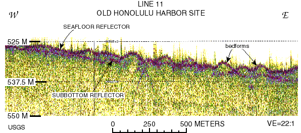
Figure 9. Bedforms, (possibily sandwaves) as seen on a 3.5ĐkHz profile collected along line
11, located on the south east side of the plumeĐshape former Honolulu Harbor site. The
bedforms here are more pronounced than those visible in figure 8, and like figure 8 (line
5), the bedforms start within the eastern edge of the former Honolulu Harbor disposal site,
and extend about 2 km into the lowĐbackscatter seafloor that is unaffected by dredged
material disposal. The presence of bedforms well outside the highĐbackscatter deposit
suggests a natural rather than anthropogenic origin.
URL:
https://pubs.usgs.gov/of/1995/of95-017/fig09.html
Maintained by: Michael Diggles
Author: Florence L. Wong
Last modified: May 27, 2005 (mfd)
|
![[Reports]](images/nav_rprt.gif)
![[Honolulu]](images/nav_hono.gif)
![[Home]](images/nav_home.gif)
![[Search]](images/nav_srch.gif)
