|
![[ Link to USGS home page ]](images/wrcmgbnr.gif)
Torresan, M.E., Hampton, M.A., Gowen, M.H., Barber, Jr., J.H., Zink,
L.L., Chase, T.E., Wong, F.L., Gann, J.T., and Dartnell, P., 1995, Final
report: acoustic mapping of dredged material disposal sites and deposits
in Mamala Bay, Honolulu, Hawaii: U.S. Geological Survey Open-file Report
95-17.
|
|
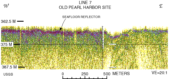
Figure 12. HighĐresolution 3.5ĐkHz profile collected on line 7 over the former Pearl Harbor
disposal site. The figure shows the lateral discontinuity or lateral variation in reflectivity of
the seafloor, the general featureless nature of the subsurface, and diffraction patterns that
correlate with bedforms on the sidescan sonar mosaic. These bedforms are also visible on
bottom photographs collected during the 1977Đ1978 site designation studies (Chave and
Miller, 1977a, 1977b, 1978a, 1978b; Tetra Tech, 1977; and U.S. Environmental
Protection Agency, 1980), and the U. S. Geological Survey 1994 sampling cruise
(Torresan and others, 1994b).
URL:
https://pubs.usgs.gov/of/1995/of95-017/fig12.html
Maintained by: Michael Diggles
Author: Florence L. Wong
Last modified: May 27, 2005 (mfd)
|
![[Reports]](images/nav_rprt.gif)
![[Honolulu]](images/nav_hono.gif)
![[Home]](images/nav_home.gif)
![[Search]](images/nav_srch.gif)
