by Michael P. Doukas
This report is preliminary and has not been reviewed for conformity with U.S. Geological Survey editorial standards or with the North American Stratigraphic Code. Any use of trade, product, or firm names is for descriptive purposes only and does not imply endorsement by the U.S. Government.
A correlation spectrometer (COSPEC) was used to measure SO2 in the Cook Inlet volcanic plumes. The upward-looking COSPEC was mounted in a fixed- wing aircraft and flown below and at right angles to the plume. The first traverse (or orbit) during a measurement was used to determine the size, location and direction of the volcanic plume. In some cases no SO2 plume was detected by the instrument and a value of zero was reported as the SO2 rate. Even though SO2 may have been sensed by the operator's nose (more sensitive than the instrument), a rate of zero was still reported. Typically, three to six traverses were made underneath the plume to determine an average SO2 burden (concentration multiplied by the pathlength) within a cross-section of the plume. Knowing the burden, the plume width and plume velocity (assumed to be the same as ambient wind speed), the emission rate of SO2 was calculated. The resultant value of SO2 is reported after values of more than one standard deviation from the average have been removed. All emission rates are reported in metric tons/day (t/d) above the background level upwind of the volcano. The use of correlation spectroscopy for determining the SO2 output of volcanoes is well established and the technique has been discussed in detail by a number of investigators (Malinconico, 1979; Casadevall and others, 1981; Stoiber and others, 1983).
Carbon dioxide in the Cook Inlet volcanic plumes was measured by an infrared spectrometer (MIRAN) tuned to the 4.26 micrometers CO2 absorption band. Volcanic CO2 is defined as that gas detected within a volcano's plume that is in excess of the concentration of ambient CO2 in the atmosphere. An external sample tube was attached to the fuselage of a twin-engine aircraft to deliver outside air to the gas cell of the MIRAN. The aircraft was then flown at several different but increasing elevations through the plume. These traverses were at right angles to the plume trajectory and defined plume area and CO2 concentration in a vertical cross-section of the plume. Plume area, CO2 density at the mean altitude of the plume, and the plume velocity (assumed to be equal to the ambient wind speed), were then used to calculate the CO2 emission rate. The resulting calculated CO2 emission rate is not an average of several measurements (as is the case for SO2 emission values), but one value. During times of low emission rates and low wind speeds, orbits within a kilometer of the vent were required, which gave low results because of slow instrumental response times. Thus, some CO2 measurements reported here are indicated to be minimum values. All emission rates are reported in metric tons/day (t/d) above the background level upwind of the volcano. The use of infrared spectroscopy for determining the CO2 output of volcanoes is discussed in detail by Harris and others (1981).
2. Listing of average SO2 and CO2 emission rates.
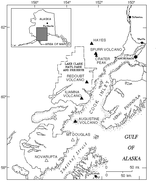
View or download 1. Map of the
Cook Inlet area, Alaska
2. Graph of
average SO2 and CO2 emission rates
3. Graph of
average SO2 and CO2 emission rates
4. Graph of
average SO2 and CO2 emission rates
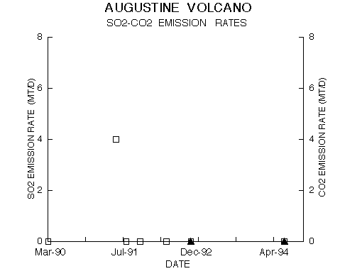
5. Graph of
average SO2 and CO2 emission rates
U.S. Department of Interior, U.S. Geological SurveyDiscussion
From March 1990 to October 1994, more than one hundred fixed-wing aircraft
flights were made by the USGS in order to measure and characterize gas
emissions from the Cook Inlet volcanoes. The beginning dates for
measurements of SO2 and CO2 emissions at Cook Inlet volcanoes are listed
in Table 1. Sulfur dioxide was detected on the majority of these
flights. Sixty-four flights were made to Redoubt Volcano, most of which
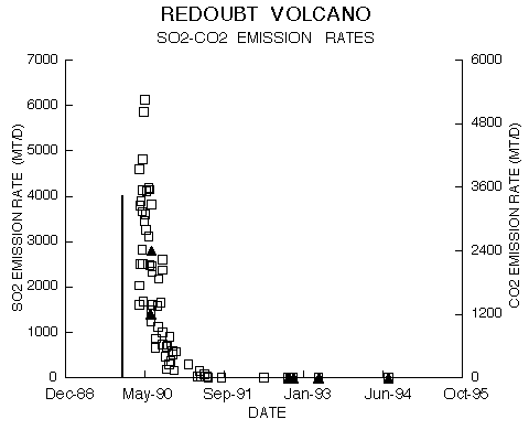
were made during the eruption of 1989-90 (table 1). Sulfur dioxide burden
in the Redoubt plume fell below detection limits in May 1991 (fig. 2).
Carbon dioxide was measured twice at Redoubt volcano in June of 1990 (fig.
2) and four times from 1992 to 1994. On a few occasions, two or three
separate SO2 gas-measurement flights to Redoubt volcano were made in a
single day. In these cases all of the emission-rate values are listed for
that day but are considered separate measurements (11, April, 1990 [2
flights]; 15, August, 1990 [3 flights]; 7, September, 1990 [2 flights]).
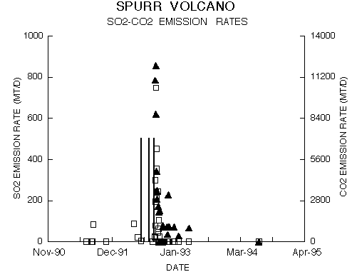
Forty flights were made to Mt. Spurr volcano most of which were made
during the 1992 eruption series (table 3). Sulfur dioxide burden at Mt.
Spurr volcano (the Crater Peak vent) fell below detection limits in
October of 1992 (fig. 3). Carbon dioxide levels were measured from
September 1992 to the present at Mt. Spurr volcano (Fig. 3, table 1).
Inflight measurements at Mt. Spurr volcano will continue until CO2 levels
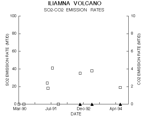
are near background levels. Nine flights were made to Iliamna volcano
(fig. 4, table 1). Seven flights were made to Augustine volcano (fig. 5,
table 1). Carbon dioxide measurements were attempted at Augustine and
Iliamna volcanoes during 1993 and 1994, with no gas detected above
atmospheric concentrations. Portions of this database have been
presented earlier by Casadevall and others (1994) and Doukas and Gerlach
(in press).
Tables
1. Beginning dates of SO2 and CO2 measurements at Cook Inlet volcanoes.
View or
downloadFigures
Acknowledgments
I acknowledge the efforts of the numerous individuals who contributed to
the success of the USGS airborne gas measurement program in Alaska by
participating in the gas flights. Funding for this work has been provided
by the USGS Volcano Hazards Program and by the USGS Global Climate History Program.
References
URL of this page: https://pubs.usgs.gov/openfile/of95-055/core/meta/
Maintained by: Eastern Publications Group Web Team
Last modified: 02.27.01 (krw)