
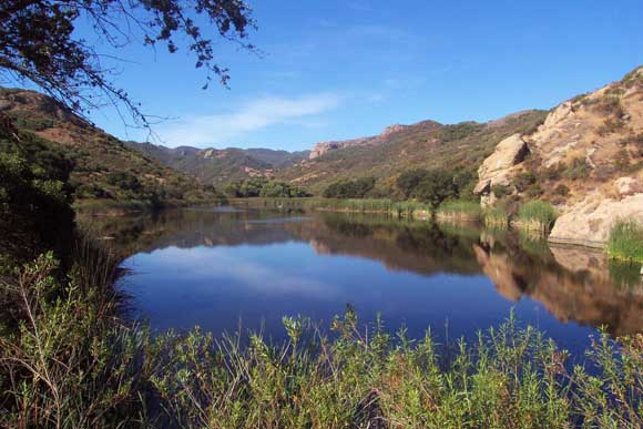
The Lake Eleanor in Thousand Oaks, California, is an eight-acre, artificial freshwater lake. This area includes diverse wildlife habitat and scenic resources, rugged hills, prominent Modelo and Topanga Formations sandstone outcrops, freshwater marsh habitat, oak woodland and coastal sage scrub. The rocky outcrops are often used by hawks and other large birds as nesting sites, and the area supports several species of rare and endangered plants. Photograph by Mark Towne.
Thousand Oaks is located in Arroyo Conejo, a region spanning both southeastern Ventura County and extreme northwest Los Angeles County in southern California. It was discovered in 1542 by Spanish explorer Juan Rodriquez Cabrillo and eventually became part of the Spanish Rancho El Conejo land grant (conejo means "rabbit" in Spanish, of which there are many in the area). It is located in the Santa Monica Mountains in the northwestern part of the greater Los Angeles area. The area is bordered by the San Fernando Valley and the city of Los Angeles to the east, Simi Hills to the north, Las Posas Hills and the Santa Rosa Valley to the northwest, Conejo Mountain (also known as Conejo Hills) and Oxnard Plain to the west, and the Santa Monica Mountains and Malibu to the southwest.
The geology of the surrounding Santa Monica Mountains is dominated by a sequence of Tertiary sedimentary and volcanic rocks. These include the Tertiary Modelo Formation and the upper part of the Topanga Formation, other minor Tertiary rocks, and Miocene volcanic and intrusive rocks of the Conejo Formation. The basement units within the Santa Monica Mountains are a series of Jurassic and Cretaceous sedimentary rocks.
The volcanic rocks of the Conejo Formation underlies much of the surrounding watersheds. The younger Tertiary sedimentary Modelo and Upper Topanga Formations flank the Conejo to the north and south. On the north slope of the Santa Monica Mountains where the Arroyo Conejo and Thousand Oaks are located, the Tertiary formations are gently folded. The south flank of the Santa Monica Mountains is structurally dominated by the Malibu Coast Fault that runs along the foot of the mountains. This fault, and associated structures, creates a complex geologic setting on the south flank of the Santa Monica Mountains. The active nature of the Malibu Coast fault and associated structures accounts for the steep and rugged coastal topography.
The most widely exposed rock units in the area are the Plio-Pleistocene marine and nonmarine Pico and Saugus formations, which crop out on the southern flank of South Mountain-Oak Ridge and on the Las Posas uplands and Las Posas Hills. Locally, the Pico Formation consists of marine siltstone and silty shale with minor sandstone and pebbly sandstone. The Saugus Formation overlies and interfingers with the Pico Formation and is composed of interbedded shallow-marine to brackish water sandstone, siltstone, pebble-cobble conglomerate, and coquina beds that grade laterally and vertically into non-marine sandstone, siltstone, and conglomerate. A local member of the Saugus Formation is exposed in the southeast corner of the map area. It is predominantly a volcanic breccia conglomerate that resembles the Conejo Volcanics breccia, but is believed to represent remnants of landslide debris shed from the Conejo Formation into a local trough during Saugus time.
Eroded from, and overlying, these bedrock formations are a series of recent alluvial units. These alluvial units include Quaternary alluvium comprised of alluvium, stream deposits, alluvial fan and floodplain deposits, beach deposits, dissected older alluvial deposits. Also present are Quaternary landslides and colluvium composed of landslide deposits and colluvium deposits. The colluvium represents relatively thick continuous deposits of soil and rock fragments that are common on the steep slopes of the coastal canyons, and generally feed the many landslides, soil slips, and debris flows.
Files available for downloading:
Download the ReadMe toaks.txt file as an unformatted documentation file describing content and formats of this publication (19 kb).
Download the ReadMe toaks.ps file as a PostScript file (864 kb).
Download toaks.tar.gz containing all the geologic database layers and supporting materials in ARC/INFO 7.x ASCII EXPORT format of the documentation files listed below packaged in a single UNIX tar file, compressed with gzip (21 MB download, 88 MB uncompressed).
Download individual database layers in ARC/INFO 7.x ASCII EXPORT format, each layer compressed with gzip:
Geology - to-geol.e00.gz containing data on faults, contacts, and geologic units (256 kb download, 960 kb uncompressed).
Structure - to-strc.e00.gz containing data on attitudes and fold axes 24 kb download, 168 kb uncompressed).
Fossils - to-foss.e00.gz containing data on exploratory oil wells (4 kb download, 15 kb uncompressed).
Composite base map - to-topo.e00.gz containing the composite quadrangle base map layer in vector format (20.2 MB download, 85.7 MB uncompressed).
For questions about the scientific content of this report, contact Russ Campbell
Download a free copy of Adobe Reader.
This report is available via print on demand.
USGS Information Services
Box 25286 Federal Center
Denver, CO 80225
Telephone: 1-888-ASK-USGS
E-mail: infoservices@usgs.gov
| Help
| PDF help |
| Publications main page
| Western Open-File Reports for 1995 |
| Department of the Interior
| U.S. Geological Survey |
| Geologic Division
| Western Earth Surface Processes Team |
| Western Region GIS Home Page |
| Privacy Statement
| Disclaimer
| Accessibility |

![]() U.S. Department of the Interior | U.S. Geological Survey
U.S. Department of the Interior | U.S. Geological Survey
URL: https://pubs.usgs.gov/of/1995/of95-088
Page Contact Information: Michael Diggles
Updated: September 12, 2007 (bwr), October 6, 2008 (mfd)