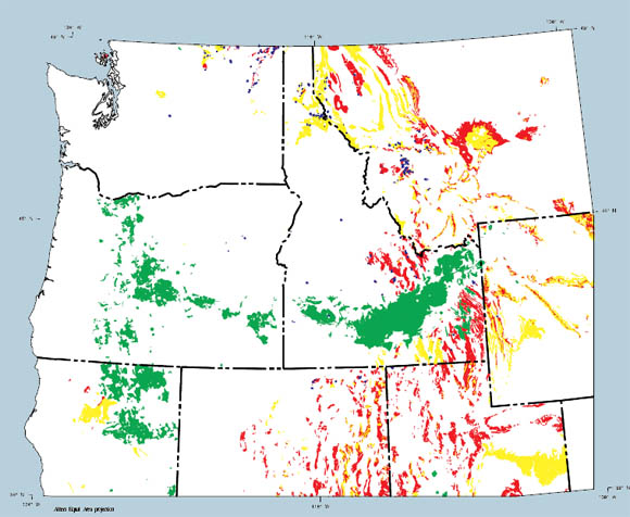
Map of potential bat habitat in the Pacific Northwest states. The red and yellow colors indicate areas with potential limestone cave habitat; green indicates lava tube habitat, and blue indicates mine habitat.
Wild animals are dependent on physical characteristics of the landscape to provide their homes. Many species of bats make their homes in limestone caves, lava tubes, and mines. These animals will also live in openings in buildings, under bridges, and natural pockets, grottos, ledges, or cracks in any exposed rock type that provides protected dark spaces. This bat-habitat map is not, therefore, a comprehensive map of cave dwelling bat habitats. It does show areas known or suspected to contain prime habitat considering only the dwelling requirements that can be addressed through readily derived geological data. It shows areas that are geologically favorable to host caves, given the scale and level of information inherent in the original state geologic mapping. The bat habitat map identifies areas where limestone caves or lava tubes may occur and where they are known to occur. It also shows locations of known underground mines. Areas on the map that are identified as having potential for limestone caves are areas where formations of thick limestone and dolomite are found, defined as the high areas on the calcium map. A second category is identified that is characterized by rocks with significant, but thinner or discontinuous beds of limestone or dolomite. Areas assigned to this category generally correspond to medium areas from the calcium map. Lava tubes generally form in basaltic lava flows and are known especially to exist in many young basalt units. Because these features form at the earth's surface and are physically unstable, generally only the younger tubes are preserved. Included are areas of known lava tubes such as Craters of the Moon National Monument in Idaho, Lava Beds National Monument in California, and Newberry Crater National Volcanic Monument, Oregon. The underground mines are taken from the U.S. Bureau of Mines MILS database. These mine locations are noted as points in the database and are represented here as small areas having a 1 kilometer radius around the mines. It is very common to find clusters of mine openings where only one point is noted in the database.
This map represents one geologic factor of many factors defining the habitat of cave dwelling bats. Table 2 describes specific map units from the state maps that were classified as potential bat habitats. The bat habitat map should be considered a model exploring the geologic characteristics that a specific species finds suitable as habitat. Other similar maps can be derived from digital geologic coverages that would identify any other known factor, or combination of factors, that a species of plant or animal finds attractive or necessary. Such maps will become especially powerful tools when geologic factors are combined with topographic, climatic, geographic, slope aspect, vegetation, or other map coverages.
Files available for downloading:
View ReadMe file (8 kb)
Download Open-File Report 95-683 as a PDF file (774 kb).
Download the Dataset in compressed (*.e00.Z) Arc/Info Export format: (6.5 MB download file, 22 MB uncompressed)
Download Additional Datasets needed to re-create the paper map in a GIS format. This file is in UNIX compressed tar format (*.tar.Z) and includes 3 coverages in Arc/Info Export format that includes the study area boundaries, state boundaries within the study area, and 1:2M lat/long corner tics (145 kb, 311 kb uncompressed).
Download Text and AML files needed to re-create the paper map in a GIS. This file is in UNIX compressed tar format (**.tar.Z) and includes 5 ASCII files (Arc/Info plot AMLs, key files, and explanatory text ( 7 kb,12 kb uncompressed).
Download the maps prepared from the digital dataset, in UNIX compressed tar (*.tar.Z) format (2.6 MB download file, 6 MB uncompressed Arc/Info GRA, HPGL2 and encapsulated PostScript file formats). The map scale is 1:2,000,000. Page size is approximately 27 by 38 inches. The maps are oriented with the long axis in the x-direction for plotting. This map was designed to be plotted on a HP Inkjet Plotter (model 650-C), but can be plotted on any full-color (inkjet or electrostatic) plotter which will accept HPGL2 code.
For questions about the scientific content of this report, contact Tom Frost
Download a free copy of Adobe Reader
This report is also available as a printed publication from:
USGS Information Services
Box 25286 Federal Center
Denver, CO 80225
Telephone: 1-888-ASK-USGS
E-mail: infoservices@usgs.gov
| Help
| PDF help |
| Publications main page
| Open-file reports [on line] |
| Department of the Interior
| U.S. Geological Survey |
| Geologic Division
|Western Mineral Resources|
| Privacy Statement
| Disclaimer
| Accessibility |
The URL for this page is: https://pubs.usgs.gov/of/1995/of95-683/
Please send comments and suggestions, or report problems, to:
Michael Diggles
Updated: May 2, 2007 (bwr, mfd)