
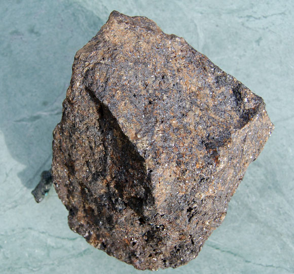
 While mining is not now a major part of the Pacific Northwest states economy, in the past metals mining was a significant resource. Gold, copper, nickel, and other minerals were developed starting in the 1860's, reached their heyday around 1900, and have continued to the present at a reduced level. This photograph is of a block of massive copper, zinc, and lead ore from west central Oregon. Photograph by B.W. Rogers.
Files available for downloading:
Download Open-File Report 95-688 as a PDF file (2.9 MB).
Download the Significant Metallic Mineral Deposits Dataset in compressed (**.Z) Arc/Info Export format (75 kb download file, 194 kb uncompressed).
Download Additional Datasets needed to re-create the paper map in a GIS. This file is in UNIX compressed tar format (**.tar.Z) and includes 5 coverages in Arc/Info Export format that includes ICBEMP Ecological Reporting Unit boundaries, study area boundaries, state boundaries within the study area, 1:2M lat/long corner tics, and 1:2M lat/long interior tics (521 kb download file, 1 MB uncompressed).
Download Text and AML files needed to re-create the paper maps in a GIS. This file is in UNIX compressed tar format (**.tar.Z) and includes 6 ASCII files that includes Arc/Info plot AMLs, key files, and explanatory text (13 kb download file, 22 kb uncompressed).
Download Map prepared from the digital dataset, in compressed (**.Z) HPGL2 format (184 kb download file, 371 kb uncompressed HPGL2). The map scale is 1:2,000,000. The map sheet size is approximately 29 by 38 inches. The map is oriented with the long axis in the x-direction for plotting. This map was designed to be plotted on a HP Inkjet Plotter (model 650-C), but can be plotted on any full-color (inkjet or electrostatic) plotter that will accept HPGL2 code.
Download Open-File Report 95-688 Appendix B as a Microsoft Excel file in a self-extracting zipped archive (*xls.exe) (100 kb download file, 298 kb unzipped Microsoft Excel format).
Download Open-File Report 95-688 Appendix B as a dBase IV file in a self-extracting zipped archive (*dbf .exe) (52 kb download file, 494 kb unzipped dBase format).
Download Open-File Report 95-688 Appendix B as a Lotus 1-2-3 file in a self-extracting zipped archive (*wk4.exe) (104 kb download file, 273 kb unzipped Lotus 1-2-3 format).
View ReadMe file: (2 kb)
For questions about the scientific content of this report, contact Art Bookstrom
Download a free copy of Adobe Reader
This report is also available as a printed publication from:
USGS Information Services
Box 25286 Federal Center
Denver, CO 80225
Telephone: 1-888-ASK-USGS
E-mail: infoservices@usgs.gov
| Help
| PDF help |
| Publications main page
| Open-file reports [on line] |
| Department of the Interior
| U.S. Geological Survey |
| Geologic Division
|Western Mineral Resources|
| Privacy Statement
| Disclaimer
| Accessibility |
The URL for this page is: https://pubs.usgs.gov/of/1995/of95-688/
Please send comments and suggestions, or report problems, to:
Michael Diggles
Updated: May 2, 2007 (bwr, mfd)