 |
|
|
||||
| Open-File Report 95–23 |
| About USGS / Science Topics / Maps, Products & Publications / Education / FAQ |
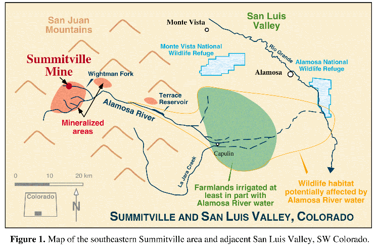
The Summitville gold mine, located at ~3800 meters (11,500 ft) elevation in the San Juan Mountains of southwestern Colorado, was the focus of extensive public attention in 1992 and 1993 for environmental problems stemming from recent open-pit mining activities. Summitville catalyzed national debates about the environmental effects of modern mining activities, and became the focus of arguments for proposed revisions to the 1872 Mining Law governing mining activities on public lands. In early 1993, the State of Colorado, U.S. Environmental Protection Agency (EPA), U.S. Geological Survey (USGS), U.S. Fish and Wildlife Service (USFWS), Colorado State University, San Luis Valley agencies, downstream water users, private companies, and individuals began a multi-disciplinary research program to provide needed scientific information on Summitville's environmental problems and downstream environmental effects. Detailed results of this multi-agency effort were presented, along with legal and policy issues, at the Summitville Forum in January, 1995, at Colorado State University, Fort Collins, Colorado.
This paper provides a scientific
perspective on Summitville based on USGS study results as of early 1995.
Further information on USGS studies are available in a separate general
interest publication
(King, 1995a) . The results demonstrate
that earth science information is needed to develop more effective
techniques for the prediction, assessment, mitigation, and remediation
of the environmental effects of mining.
Gold was first discovered at Summitville in 1870. Significant gold production from underground workings occurred prior to 1900. In 1903, the

Reynolds adit was driven to drain the underground workings and serve as an ore haulage tunnel. Production occurred sporadically through the 1950's. The district received some exploration attention in the 1970's as a copper prospect, but no mining for copper was pursued.
Similar to many historic gold mining districts in the western
United States, Summitville received renewed interest in the early 1980's
due to technological advances that allow extraction of low-grade ores
with cyanide heap leach techniques. In 1984, Summitville Consolidated
Mining Company, Inc. (SCMCI), initiated open pit mining of gold ore from
rocks surrounding the historic underground workings, where gold
concentrations had been too low to be economic for the underground
mining operations. Ore from the pit was crushed and placed on a heap
leach pad overlying a protective liner. Cyanide solutions were
sprinkled onto the heap and trickled down through the crushed ore,
dissolving the gold. The processing solutions were then collected from
the base of the heap leach pile, and the gold was chemically extracted
from the solutions.
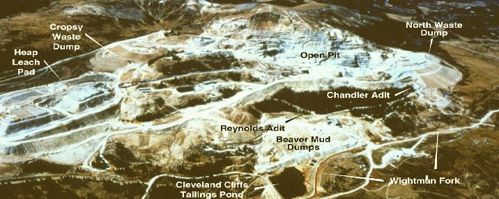
Environmental problems developed soon after the initiation of open-pit mining. Acidic, metal rich drainage into the Wightman Fork of the Alamosa River increased significantly from numerous sources on site, including the Reynolds adit and the Cropsy waste dump (Pendleton and others, 1995) . Cyanide-bearing processing solutions began leaking into an underdrain system beneath the heap leach pad, where they then mixed with acid ground waters from the Cropsy waste dump. Cyanide solutions also leaked from transfer pipes directly into the Wightman Fork several times over the course of mining.
SCMCI had ceased active mining and had begun environmental remediation when it declared bankruptcy in December 1992 and abandoned the mine site. The bankruptcy created several immediate concerns. Earlier in 1992, the company had brought a water treatment plant on line to begin treating the estimated 150 to 200 million gallons of spent cyanide processing solutions remaining in the heap; however, treatment was proceeding so slowly relative to influx of snowmelt waters that the waters were in danger of overtopping a containment dike and flowing directly into the Wightman Fork. In addition, piping carrying the processing solutions to the treatment plant would have frozen within several hours, releasing cyanide solutions and stopping water treatment.
At the request of the State of Colorado, the U.S. Environmental Protection Agency (EPA) immediately took over the site under EPA Superfund Emergency Response authority and increased treatment of the heap leach solutions, thereby averting a catastrophic release of cyanide solutions from the heap. Summitville was added to the EPA National Priorities List in late May, 1994. Ongoing remediation efforts include decommissioning of the heap leach pad, plugging of the Reynolds and Chandler adits,backfilling of the open pit with acid-generating mine waste material, and capping of the backfilled pit to prevent water inflow. The total cost of the cleanup has been estimated to be from US $100 million to $120 million.
The environmental problems at Summitville have been of
particular concern due to the extensive downstream use of Alamosa River
water for livestock, agricultural irrigation, and wildlife habitat.
Increased acid and metal loadings from Summitville are suspected to have
caused the 1990 disappearance of stocked fish from Terrace Reservoir and
farm holding ponds along the Alamosa River (Colo. Div. of Wildlife, oral
comm., 1993). The Alamosa River is used extensively to irrigate crops
in the southwestern San Luis Valley. Important crops include alfalfa
(used for livestock feed), barley (used in beer production), wheat, and
potatoes; there has been concern about potential adverse effects of the
increased acid and metal loadings from Summitville on the metal content
and viability of these crops. The Alamosa River also feeds wetlands
that are habitat for aquatic life and migratory water fowl such as ducks
and the endangered whooping crane; there are concerns about
Summitville's effects on these wetlands and their associated wildlife.
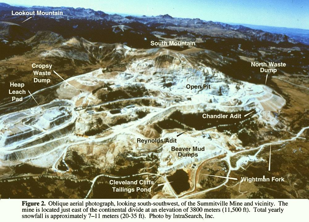
USGS efforts at the Summitville site since open pit mining began include detailed geologic mapping in the open pit (Gray and Coolbaugh, 1994a), characterization of the site's environmental geology and geochemistry (Plumlee and others, 1995 a and b), studies of cyanide degradation (Plumlee and others, 1995b), and geophysical resistivity surveys (Bisdorf, 1995).
The Summitville mine drainage waters are among the most acidic and metal-rich in Colorado (Plumlee and others, 1995b), with pH generally below 3 and high to extreme concentrations of iron, aluminum, copper, zinc, arsenic, and other metals. The acidic, metal-rich nature of the waters is a predictable consequence of the deposit's geologic and geochemical characteristics (Plumlee and others, 1995 a; Gray and others, 1994b). Prior to mineralization, the volcanic dome rocks that host the deposit were intensely altered by highly acidic volcanic gas condensates. Sulfide-rich mineral assemblages containing pyrite, enargite, chalcopyrite, and other minerals were subsequently deposited in the altered host rocks by hydrothermal fluids. Open-pit mining exposed large volumes of previously unoxidized sulfides to weathering. Acid-mine drainage with high concentrations of metals forms by the reactions of these previously unoxidized sulfides with oxygenated groundwaters. Further, the highly altered host rocks have very little capacity to react with and consume the acid generated by sulfide oxidation, thereby providing little or no mitigation of the acid drainage. Evaporation further increases the concentrations of acid and metals in waters draining mine dumps and open-pit waters. Soluble salts such as chalcanthite (a copper sulfate), jarosite (a potassium-iron sulfate), and halotrichite (an iron-aluminum sulfate) form by the extreme evaporation of acid waters during dry periods; dissolution of these salts during snowmelt or summer storm events leads to the transient release of even more acidic and metal-rich water pulses from the site (Plumlee and others, 1995 a and b).
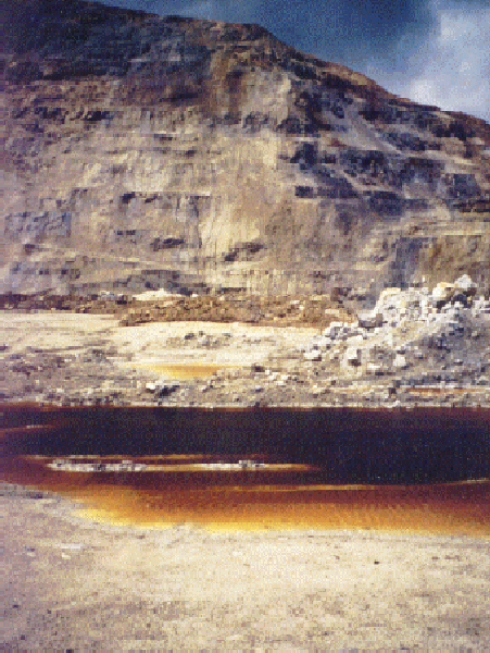
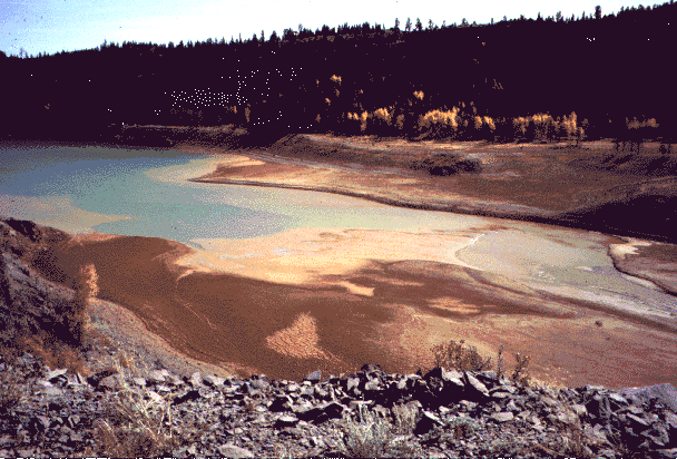
Acidic metal-rich puddles in the Summitville open pit formed by dissolved secondary salts in rainwater.
The backfilling and capping of the open pit will help reduce acid drainage from Summitville by reducing water- and snow-catchment and by decreasing the amounts of exposed sulfides and soluble salts. However, some level of acid discharge will likely continue from the site. Significant volumes of unweathered sulfides and soluble salts are dispersed throughout the site on roadways, in soils, and in other surficial materials. These solids are a long-term source of metals and acid that will be difficult to remediate. In May, 1994, four months after the Reynolds adit was plugged, a plug on the Chandler adit (located 150 feet above and 2400 feet north of the Reynolds adit) failed and began leaking acidic, metal-rich waters into the Wightman Fork. Although the Chandler is currently being re-plugged, the leak underscores the fact that it is difficult to prevent leakage of groundwaters from a highly fractured and mined mountain. The plugging of the Reynolds adit also resulted in the predictable reactivation of acid seeps and springs that had drained the site prior to underground mining; these natural seeps had left behind extensive, mappable deposits of brown iron hydroxide minerals(Plumlee and others, 1995b). Long-term leakage of acid groundwaters from these natural discharge points is unavoidable.
USGS studies show that the severe acid drainage problems at Summitville may have actually helped mitigate the effects of accidental cyanide releases. Experiments in which Summitville heap leach solutions were mixed with acid-drainage waters from the site indicate that metal-cyanide complexes in the heap leach solutions react readily with acid in the drainage waters to form hydrogen cyanide, which then volatilizes into the atmosphere (Plumlee and others, 1995b).
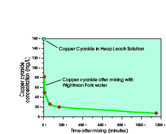
Plot of cyanide concentration vs. time in heap leach effluents reacting with acid mine drainage.
In addition,
copper cyanide in the heap leach solutions reacts with iron from the
drainage waters to form solid copper-iron cyanide compounds, which are
then degraded through reactions catalyzed by sunlight. Thus, most
cyanide species that were accidentally leaked into the Wightman Fork
(Fig. 2) probably degraded rather rapidly due to mixing with the site's
acid drainage, especially if the leaks occurred on sunny summer days
optimal for maximum cyanide volatilization and photolytic degradation.
However, if leaks occurred in the winter, cyanide may have persisted
considerably farther downstream due to reduced rates of volatilization.
Relatively high concentrations of thiocyanate may have persisted
downstream due to its stability in acidic solutions.
Increased acid and metal loadings from Summitville are suspected to have caused the 1990 disappearance of stocked fish from Terrace Reservoir and farm holding ponds downstream on the Alamosa River (Colo. Div. of Wildlife, oral comm., 1993). However, significant natural contamination also enters the Alamosa from unmined or minimally mined mineralized areas (Walton-Day and others, 1995; Miller and others, 1995a, 1995b; Miller and McHugh, 1994). Creek names such as Iron, Alum, and Bitter attest to the degraded quality of waters emanating from these areas.
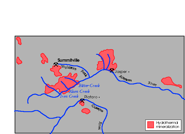
Mineralized areas in and near the Alamosa River basin
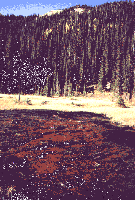
Natural acidic iron spring, Alamosa River headwaters
Geologic studies (Bove and others, 1995)
of the mineralized areas south of Summitville have shown that
hydrothermally-altered and sulfide-mineralized rocks are the source for
numerous acid springs and seeps. In addition, physical erosion rates
greatly exceed chemical weathering rates in the most highly altered
areas. In these areas, unoxidized sulfides are exposed at the ground
surface and are transported as sediments into the Alamosa River, where
they serve as further sources for acid and metals.

Aluminum concentrations along the Alamosa River, April and June 1993; Walton-Day and others, 1995
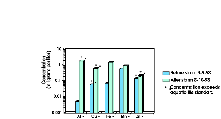
Effects of a thunderstorm on Alamosa River metal concentrations; Ortiz and others, 1995b
Synoptic water sampling studies show that concentrations of aluminum, iron, and acid derived from mineralized areas other than Summitville can exceed aquatic life standards in Alamosa River waters during some times of the year, such as during early spring snowmelt and summer thunderstorms. (Walton-Day and others, 1995; Ortiz and others, 1995b; Ward and Walton-Day, 1995; von Guerard and Ortiz, 1995) However, during much of the year, Summitville is the dominant source of iron, aluminum, copper, manganese, zinc, and acidity in the Alamosa River. Remote imaging spectroscopy studies (King and others, 1995b) also document the contributions of metal-bearing sediments in the Alamosa River from both Summitville and the unmined mineralized areas.
USGS studies are currently underway to estimate baseline metal and pH conditions that may have existed in the Alamosa River basin prior to mining (Miller and others, 1995a, 1995b); results of these studies should be used to determine how much remediation at Summitville is necessary and realistic in a basin-wide context.
Terrace Reservoir
may serve as a sink and/or source for metals in the Alamosa River. For
example the reservoir serves as a sink for metals sorbed onto
particulates that settle to form bottom sediments. USGS studies are
currently underway to evaluate whether metals can be liberated from the
sediments under favorable geochemical conditions
(Edelmann and others, 1995; Ortiz and
others, 1995a;
Horowitz and Elrick, 1995).
A regional geochemical survey of the San Luis Valley shows that soils on the Alamosa River alluvial fan in the southwestern San Luis valley contain anomalous concentrations of copper and other metals (Tidball and others, 1995 in press). These metal anomalies largely reflect the pre-mining erosion of mineralized areas in the Alamosa River basin. Effects of irrigation with Alamosa River water on soil metal levels may be generally secondary compared to the effects of the mineralized source material for the soils (Erdman and Smith, 1993).
Studies of San Luis valley irrigation waters taken from the Alamosa River show that degraded water quality can persist more than 60 km downstream from Summitville (Smith and others, 1995). This results from (1) natural acid and metal contamination from other mineralized areas; (2) the lack of large diluting tributaries to the Alamosa River, and; (3) the lack of acid-buffering capacity of the volcanic rocks through which the Alamosa River and tributaries flow (Plumlee and others, 1995a in press).
There has been considerable concern about crops irrigated with Alamosa River water. Dominant crops include barley (used in the beer brewing industry) and alfalfa (used as livestock feed). Results of 1993 USGS studies show that irrigation with Alamosa River waters led to slightly increased concentrations of copper and other metals in the alfalfa and barley relative to levels of these metals in alfalfa and barley irrigated with water from other sources Erdman and Smith, 1993
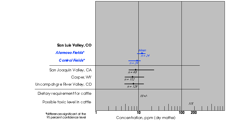
Copper concentrations in alfalfa ;
Erdman and others, 1995b
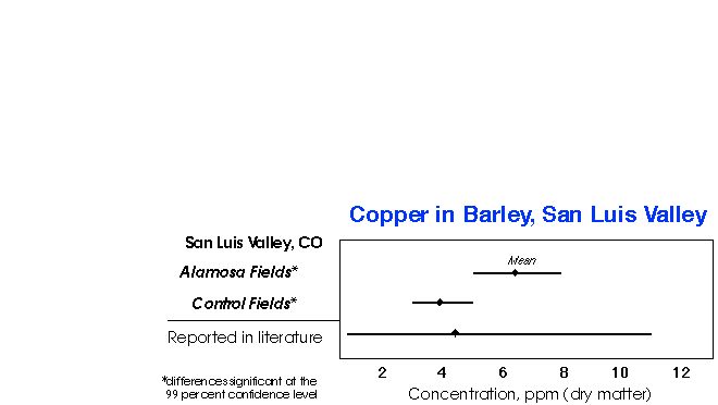
Copper concentrations in barley ; Stout and Emerick, 1995
However, these 1993 metal concentrations were well within the concentration ranges of copper measured in alfalfa and barley grown elsewhere in the United States. The copper concentrations in alfalfa were also well below the maximum levels tolerable in cattle (Erdman and Smith, 1993; Erdman and others, 1995b). Some local farmers feel that, because copper is an essential nutrient for livestock and is generally low to deficient in feed grown in the San Luis valley (Brown, 1995), the nutritional quality of the alfalfa is enhanced, not diminished, by irrigation with Alamosa River waters. However, the metal content and acidity of Alamosa River irrigation waters increased substantially in July and August of 1994 (Smith and others, 1995). Data from alfalfa sampled in 1994 indicate that the increased levels of metals and acid in the waters resulted in further increases in copper content of the alfalfa that, while optimal for dairy cattle, may be approaching the maximum levels tolerable for sheep in some samples (Erdman and Smith, 1995a in press).
Studies are currently underway to assess the use of multi-spectral remote sensing data to map soil mineralogy and vegetation characteristics in the San Luis Valley (Clark and others, 1995). Mapping of crop type and stress levels has been successful using this technique. Ongoing studies are investigating whether mapped crop stress levels can be correlated with source of irrigation water.
Studies of wetlands in the San Luis Valley show that concentrations of copper and zinc in sediments and plants are greater in wetlands receiving Alamosa River water than in a wetland fed by water from other sources; this indicates that some copper from Summitville and zinc from Summitville and other sources are reaching the wetlands (Balistrieri and others, 1995 in press). However, the Alamosa River-fed wetland waters have basic pH values and very low metal concentrations. Impacts on aquatic life and waterfowl are currently under evaluation.
Tree-ring chemistry was also evaluated to help assess impacts of Summitville on plant ecosystems (Gough and others, 1995 in press): the metal content of sequential tree rings, spanning 30 years of growth, was measured in cottonwoods and aspens along the Alamosa River from the Wightman Fork downstream into the San Luis Valley. Results for Cu and Zn show no clear effects from Summitville, and the limited number of analyses completed to date preclude a detailed interpretation of the results (Gough and others, 1995 in press).
Although final scientific judgments about Summitville and its environmental effects await the outcome of ongoing research, some preliminary conclusions can be drawn: (1) Extreme acid rock drainage, rather than cyanide releases, is the dominant long-term environmental concern at Summitville. Extensive remedial efforts will be required to minimize weathering and dissolution of unweathered sulfides and soluble metal salts. Some level of long-term acid- and metal-release into the Wightman Fork will likely occur in spite of the remedial efforts, however, due to leakage from natural discharge points and the wide distribution of acid-generating material throughout the site. (2) It is likely that natural contamination adversely affected water quality and fish habitat in the Alamosa River prior to mining, and will continue to have adverse effects even when acid drainage from Summitville is remediated. Thus, realistic geochemical baselines for the Alamosa River basin must be defined in order to set realistic remediation standards for the Summitville site. (3) As of late 1993, Summitville apparently had no discernible short-term adverse effects on the barley or alfalfa crops irrigated with Alamosa River water. However, increases in metal content of irrigation waters and alfalfa measured in the summer of 1994 underscore the need for prompt and effective remediation at the site to ensure that no adverse effects develop over the longer term.
Results of Summitville research to date underscore the crucial need for geoscientific information in predicting, assessing, and remediating the environmental effects of mining. For example, Summitville shows how geologic and geochemical information should be used in the future to more effectively anticipate and mitigate potential environmental effects of metal mining. Similarly, a careful consideration of Summitville's geologic and geochemical characteristics (and their controls on hydrology and acid-drainage formation) is needed to help refine and anticipate the effectiveness of remedial measures at the site. In the assessment of Summitville's downstream environmental effects, geoscience studies contribute much by: (1) providing a scientific evaluation of the actual, rather than perceived, environmental problems and their effects; (2) showing that natural environmental effects of other mineralized areas must also be considered, and; (3) showing that Summitville's effects on aquatic life, agriculture, and wetlands ecosystems can best be understood only when examined in an integrated geologic, geochemical, and biological context.
USGS project participants include: Cathy Ager, Laurie Balistrieri, Bob Bisdorf, Dana Bove, Paul Briggs, Doug Cain, Roger Clark, Pat Edelman, Jim Erdman, Walt Ficklin, David Fitterman, Marta Flohr, Larry Gough, John Gray, Trude King, Fred Lichte, John McHugh, Al Meier, Bill Miller, Maria Montour, Elwin Mosier, Nicole Nelson, Roger Ortiz, Geoff Plumlee, Charlie Severson, Kathy Smith, Tom Steven, Kathleen Stewart, Peter Stout, Greg Swayze, Ron Tidball, Rich Van Loenen, Paul von Guerard, Katie Walton-Day, Elizabeth Ward, Gene Whitney, Melinda Wright, and Tom Yanosky. Cooperating agencies include: U.S. EPA, U.S. Fish and Wildlife Service; State of Colorado, Departments of Natural Resources, Health, and Agriculture; Colorado State University and CSU Extension Service; Colorado School of Mines; Auburn University; Environmental Chemical Corp.; San Luis Valley consulting firms, water conservancy districts, and water users.
| AccessibilityFOIAPrivacyPolicies and Notices | |
| |
|