![]()
Landslide damage from the Northridge earthquake was only moderate because the area of greatest landslide activity is not yet heavily developed. However landslides did, as described below, block roads; damage and destroy homes; locally disrupt water mains, sewers, and power lines; and damage oil- and gas-production facilities.
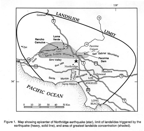
Landslides in the Santa Susana and western San Gabriel Mountains blocked many roads and thus hampered relief efforts and exacerbated the overall transportation problems caused by the earthquake (fig. 16).
 Figure 16. Landslides blocking road near I-5 interchange with California State Highway 14.
Landslides impeded traffic flow that was diverted onto secondary highways as a result of the collapsed interchange at I-5 and California State Highway 14. Rock falls and rock slides closed many of the alternate routes across the San Gabriel Mountains from the Lancaster/Palmdale and Santa Clarita Valley areas (plate 1) to Los Angeles, and it was several days before some of these routes were cleared of rock debris and made available to commuters.
Dozens of homes in the central and eastern Santa Monica Mountains were moderately or severely damaged by reactivation of deep block slides. Although the landslide features are subtle and the damage patterns complex, making it difficult to distinguish shaking damage from ground-failure damage in this area, many clusters of damaged homes clearly relate to reactivation of old, deep block slides. Fill failures in some areas also damaged hundreds of homes and other buildings.
Shallow, disrupted slides also seriously damaged many structures. One large home in Pacific Palisades was destroyed when the bluff on which it was built failed during the earthquake and caused half the house to be torn loose and cascade down the steep slope (see photograph on report cover). In the Santa Susana Mountains, rock falls damaged or destroyed several non-residential buildings, but no injuries were reported. In Tapo Canyon, north of Simi Valley in the Santa Susana Mountains, rock falls came closest to hitting residences; fortunately, only outbuildings were crushed beneath rock falls (fig. 17).
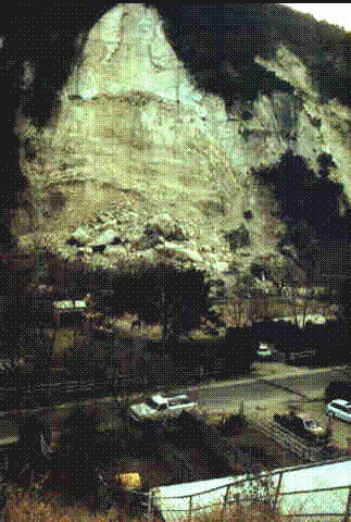 Figure 17. Rock fall in Tapo Canyon that crushed outbuildings in a residential area in the Santa
Susana Mountains.
Figure 17. Rock fall in Tapo Canyon that crushed outbuildings in a residential area in the Santa
Susana Mountains.Considerable damage also was done to roads, pipelines, and well machinery within oil fields in the Santa Susana Mountains from rock falls, slumps, and block slides triggered by the earthquake. Many pump pads, pipelines, and roads were undermined by deep slumps or inundated by rock falls from above during the earthquake. In the Aliso Canyon oil field at the southeastern margin of the Santa Susana Mountains, large earth-moving trucks were engaged for several months just in removing rock debris from the oil-field roadways. One block slide in the Aliso Canyon oil field severed well pipe and damaged a well pump that was located at the head of the failure (fig. 18). Landslides in the Ramona oil field, described previously, also seriously damaged oil-field infrastructure.
 Figure 18. Slump in Aliso Canyon oil field that damaged oil-well pad, well casing, and pump.
The main scarp daylighted directly beneath the well pad, and the slide mass moved downward (left to right in photo)
about 2 m. Oil pump was moved to position in upper left of photo after the earthquake-triggered landslide movement.
Pipeline visible in upper center of photo was left suspended when the landslide moved downslope and removed its
foundation support.
Figure 18. Slump in Aliso Canyon oil field that damaged oil-well pad, well casing, and pump.
The main scarp daylighted directly beneath the well pad, and the slide mass moved downward (left to right in photo)
about 2 m. Oil pump was moved to position in upper left of photo after the earthquake-triggered landslide movement.
Pipeline visible in upper center of photo was left suspended when the landslide moved downslope and removed its
foundation support.Pacoima Canyon, in the San Gabriel Mountains, experienced extreme landslide damage during the earthquake. Several large rock falls and rock slides from the precipitous slopes of the canyon dumped hundreds of thousands of cubic meters of landslide debris into the canyon, which blocked access to Pacoima Dam and damaged areas around the dam (fig. 19). About 50,000 m³ of landslide debris was trucked from the canyon following the earthquake. Rock falls damaged the spillway and the shotcrete covering the dam abutment. Continuing failure of material weakened by the earthquake seriously hampered repair efforts.
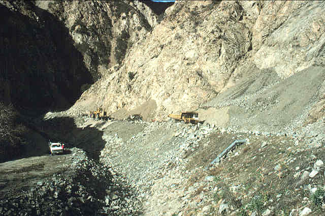 Figure 19. Deposits from earthquake-triggered landslides in Pacoima Canyon just below Pacoima
Dam (plate 2).
Figure 19. Deposits from earthquake-triggered landslides in Pacoima Canyon just below Pacoima
Dam (plate 2).An unfortunate additional effect of the rock falls and rock slides in the Santa Susana Mountains was an outbreak of valley fever (coccidioidomycosis), which can only be contracted by inhaling airborne dust containing the fungal spores that cause the disease (Jibson and others, 1994b). The highly disruptedlandslides triggered by the earthquake generated dense dust clouds (fig. 20) that blew downwind (southwestward) into Simi Valley (fig. 1, plates 1 and 2), where a tight cluster of more than 150 cases of valley fever were diagnosed in the seven weeks following the earthquake (Centers for Disease Control and Prevention, 1994). During all of 1993, all of Ventura County had reported only 52 cases. Three valley fever fatalities occurred, which accounts for about 5 percent of the total earthquake fatalities.
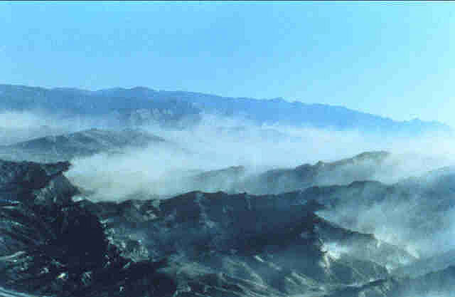 Figure 20. Dust clouds created by earthquake-triggered landslides in Santa Susana Mountains.
Dust was blown southwestward over Simi Valley where an epidemic of valley fever (coccidioidomycosis) occurred.
Figure 20. Dust clouds created by earthquake-triggered landslides in Santa Susana Mountains.
Dust was blown southwestward over Simi Valley where an epidemic of valley fever (coccidioidomycosis) occurred.
The digital maps of more than 11,000 earthquake-triggered landslides provide a data set of unprecedented completeness for detailed analysis. We currently are analyzing landslide distribution in relation to geologic structure, stratigraphy, and topography. The earthquake also produced hundreds of strong-motion records, which provide an extraordinarily detailed regional view of the variation in ground shaking. This extensive database will allow quantitative modeling of the relation between strong ground shaking, landslide susceptibility, and landslide distribution. The area of the greatest landslide concentration currently is undeveloped, but many parts of this area in the Santa Susana Mountains are slated for future dense residential development. We anticipate using the data and modeling results from the Northridge earthquake to produce regional maps of earthquake-induced landslide hazards that can be used to make informed decisions regarding development in the areas most susceptible to seismically triggered landsliding.
Graphics files of plates 1 and 2 are available to users who have the capability of plotting large-format, color encapsulated-PostScript, PDF, and HPGL2 graphics files. In addition, the landslide information portrayed on plates 1 and 2 is stored in a digital spatial data file and is available to users of Arc/Info GIS software. All files are available via the Internet.
The data files can be accessed from downloads.
The files plate1.eps.Z and plate1.eps.zip and plate1.hp.Z and plate1.hp.zip are compressed files of plate 1 that are in encapsulated PostScript and HPGL2 formats, respectively. The graphics files will produce 1:100,000-scale maps whose sheet dimensions are 40 inches wide by 36 inches high.
The files plate2.eps.Z and plate2.eps.zip and plate2.hp.Z and plate2.hp.zip are compressed files of plate 2 that are in encapsulated PostScript and HPGL2 formats, respectively. The graphics files will produce 1:100,000-scale maps whose sheet dimensions are 40 inches wide by 36 inches high.
The files of95-213_plate1.pdf and of95-213_plate2.pdf are Portable Document Format (PDF) files of plates 1 and 2. The graphics files will produce 1:100,000-scale maps whose sheet dimensions are 40 inches wide by 36 inches high. To view PDFs, the latest version of Adobe Reader or similar software is required. Download the latest version of Adobe Reader, free of charge.
The landslide data files landslide.e00.Z and landslide.e00.zip are the compressed ASCII form of a file landslide.e00 that was produced by the ARC/Info command EXPORT. Arc/Info users should decompress the landslide.e00.Z or landslide.e00.zip file and run the IMPORT command to produce the landslide coverage:
Arc: import cover landslide.e00 landslide
The coverage has both line and polygon topology. Item SLIDE in the polygon attribute table landslide.pat takes a value of 1, which corresponds to label points within landslide polygons; an item value of 0 corresponds to label points within polygons (such as inliers) in which landslides are not found.
Questions regarding digital database dissemination should be directed to the authors:
|
Harp, Edwin L. U.S. Geological Survey Box 25046, MS 966 Denver Federal Center Denver, Colorado 80225 (303) 273-8557 harp@usgs.gov |
Jibson, Randall W U.S. Geological Survey Box 25046, MS 966 Denver Federal Center Denver, Colorado 80225 (303) 273-8577 jibson@usgs.gov |
The database, identified as landslide, has been approved for release and publication by the Director of the USGS. Although this database has been subjected to rigorous review and is substantially complete, the USGS reserves the right to revise the data pursuant to further analysis and review. Furthermore, it is released on condition that neither the USGS nor the United States Government may be held liable for any damages resulting from its authorized or unauthorized use.
David Keefer and Ray Wilson of the U.S. Geological Survey assisted in the post-earthquake reconnaissance efforts and in defining the landslide limits. John Michael and Art Tarr of the U.S. Geological Survey helped construct the digital landslide map. Al Barrows and Pam Irvine of the California Division of Mines and Geology, and Robert Larson of Los Angeles County provided useful information on the location and nature of many landslides triggered by the earthquake.
HTML Creation
This HTML was created by Stephane Vergier (ENTPE--Ecole Nationale des Travaux Publics de l'Etat) and Philip Powers, updated 2011 by Michael Diggles (both at U.S. Geological Survey)
Centers for Disease Control and Prevention, 1994, Emerging infectious diseases: Coccidioidomycosis following the Northridge earthquake, California, 1994: Morbidity and Mortality Weekly Report, v. 43 no. 10, p. 194-195.
Cloud, W.K., and Hudson, D.E., 1975, Strong motion data from the San Fernando, California, earthquake of February 9, 1971, in Oakeshott, G.B., ed., San Fernando, California, earthquake of 9 February 1971: California Division of Mines and Geology Bulletin 196, p. 273-303.
Harp, E.L., and Noble, M.A., 1993, An engineering rock classification to evaluate seismic rock-fall susceptibility and its application to the Wasatch Front: Bulletin of the Association of Engineering Geologists, v. 30, p. 293-319.
Jibson, R.W., Harp, E.L., Keefer, D.K., and Wilson, R.C., 1994a, Landslides triggered by the 17 January 1994 Northridge, California earthquake: Earthquakes and Volcanoes, U.S. Geological Survey, v. 25, no. 1 [in press].
Jibson, R.W., Harp, E.L., Spiegel, R.A., Hajjeh, R.A., Schneider, E.E., Marshall, G.A., and Stein, R.S., 1994b, Landslides can be hazardous to your health: An outbreak of coccidioidomycosis (valley fever) caused by landslides triggered by the 1994 Northridge, California, earthquake [abstract]: Geological Society of America, Abstracts with Programs, v. 26, no. 7, p. A-318.
Keefer, D.K., 1984, Landslides caused by earthquakes: Geological Society of America Bulletin, v. 95, p. 406-421.
Shakal, A., Huang, M., Darragh, R., Cao, T., Sherburne, R., Malhotra, P., Cramer, C., Sydnor, R., Graizer, V., Maldonado, G., Peterson, C., and Wampole, J., 1994, CSMIP strong-motion records from the Northridge, California earthquake of 17 January 1994: California Department of Conservation, Division of Mines and Geology, Report No. OSMS 94-07.
Wald, D.J., and Heaton, T.H., 1994, A dislocation model of the 1994 Northridge, California, earthquake determined from strong ground motions: U.S. Geological Survey Open-File Report 94-278, 53 p.
![]()
![]()

![]() U.S. Department of the Interior |
U.S. Geological Survey
U.S. Department of the Interior |
U.S. Geological Survey
URL: http://pubsdata.usgs.gov/pubs/of/1995/ofr-95-0213/EFFECTS.HTML
Page Contact Information: GS Pubs Web Contact
Page Last Modified: Wednesday, 23-Nov-2011 14:36:48 EST