
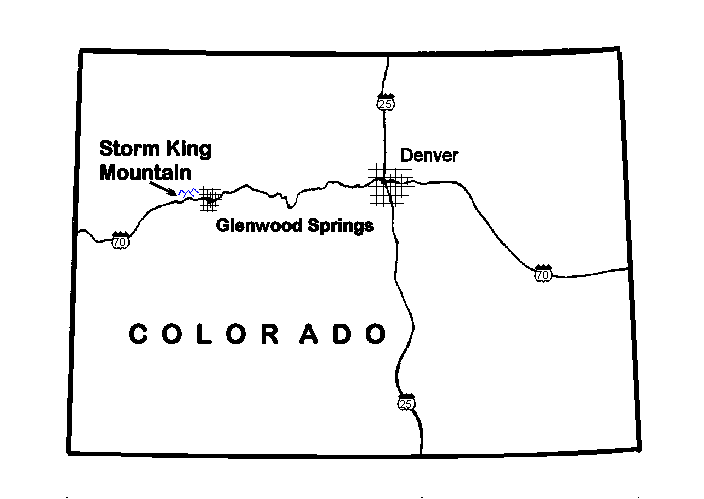
The South Canyon Fire of July 1994 burned 2,000 acres of pinyon-juniper and mountain shrub vegetative communities on Storm King Mountain near Glenwood Springs, Colorado. On the night of September 1, 1994 at approximately 10:30 pm, in response to a torrential downpour, a wall of mud, rocks and burned trees came crashing down onto Interstate I-70 in four places. Throughout the night and early morning hours material continued to flow out of the canyons, inundating sections of a 3-mile length of Interstate I-70 under tons of rocks and mud. Although the burned area was seeded in November of 1994, the potential for continuing and destructive debris-flow activity still remains. The objective of this study is to describe the September 1994 events and to provide a preliminary definition of existing potential hazards in the event of rainstorms of similar intensity to the September storm or during a protracted snow melt in the spring. Detailed mapping from 1:8000-scale aerial photographs taken on November 10, 1994, coupled with extensive field observations and measurements show that the net result of the September rainstorm was to flush dry-ravel deposits from the side channels, transport loose, larger material from the main channels, and precipitate the erosion of unconsolidated, burned surficial soil from the hillsides. This material was mobilized into a combination of debris- and hyperconcentrated flow. The flows inundated approximately 35 acres along I-70 with roughly 91,000 ydsł of material. Flow velocities from 10 to 28 ft/sec are calculated, with discharges between 1000 and 4000 ftł/sec. Approximately 15% of the loose, unconsolidated soil on the hillsides was removed to a depth of 1.5 inches by rilling and sheet wash. Three existing potential geologic hazards are identified on Storm King Mountain: continued debris-flow activity resulting from accelerated incision and entrainment of channel alluvium by high-volume surface-water flows, mobilization of colluvial material on the channel side slopes and valley-fill material in the canyons by downcutting, and erosional destabilization of deep-seated landslide deposits. Finally, steps to evaluate the potential impact of the first, and most likely, hazard, as well as steps to assess the potential of the occurrence of the following two, less likely, hazards are described.
The South Canyon Fire of July 1994 burned 2,000 acres of pinyon-juniper and mountain shrub vegetative communities on Storm King Mountain near Glenwood Springs, Colorado (Figure 1 and figure 2). In the days following the fire, abundant ash and loose mineral soil was transported downslope and accumulated in drainages and on side slopes. Torrential rains the night of September 1, 1994 mobilized this loose, unconsolidated material, loose material stored in the canyons over the years, and burned soil remaining on the hillsides, into debris flows. Throughout the night, material from these flows inundated sections of a 3-mile length of Interstate I-70 under tons of rocks and mud (Plate 1). Miraculously, although 30 vehicles and their drivers were engulfed by the flows, and in some cases, pushed into the Colorado River, no deaths, and only minor injuries resulted from this cataclysm. Even though the burned area was reseeded in November of 1994 with grass mixtures (M. McGuire, Bureau of Land Management, personal communication, 1995), the potential for continuing and destructive debris-flow activity still remains. The objective of this study is to provide a preliminary definition of existing potential hazards in the event of rainstorms of similar intensity to the September storm and during a protracted snow melt in the spring. Approach To properly evaluate the fire-debris flow hazard, and to implement emergency erosion and debris flow control work to mitigate the risk, it is necessary to understand the relations between the post-fire physical characteristics of the Storm King Mountain watershed and sediment-transport activity. At the onset, I engage in a general discussion of the nature of fire-related sedimentation events; this includes descriptions of the sediment-water flow continuum, and the role of vegetation in slope stability. Then, moving specifically to Storm King mountain, the geologic setting and the physical configuration of the watershed are described. Field observations by Colorado Geological Survey and Bureau of Land Management personnel are then used to describe the conditions in the watershed following the fire and preceding the debris flows. The September, 1994 events are then described and evaluated using a number of different techniques. Detailed examination of aerial photographs of the Storm King mountain watershed taken on November 10, 1994 at a scale of 1:8000, coupled with extensive field observations and measurements, were used to generate a map of the September events. The volume of material deposited at the mouths of the canyons in the watershed was estimated from this map and from field measurements. Field observations and measurements were used to evaluate the dominant mechanisms for mobilization of sediment from the burned basins, to characterize the flow processes, and to calculate the velocities and discharges of the flows themselves. Laboratory testing was used to characterize the physical properties of the soils on the hillsides, and the material involved in the flows. Finally, a synthesis of the information gleaned from the above analyses allows for discussion of a number of different scenarios for the remaining hazards. Recommendations are proposed to evaluate the potential severity of these hazards.
| AccessibilityFOIAPrivacyPolicies and Notices | |
| |
|