Open-File Report 96-738
INTRODUCTION
The Alaska Volcano Observatory (AVO) responded to eruptive activity or suspected volcanic activity (SVA) at 6 volcanic centers in 1995 (tables 1, 2): Mount Martin (Katmai Group), Mount Veniaminof, Shishaldin, Makushin, Kliuchef/Korovin, and Kanaga. Of these, AVO has a real-time, continuously recording seismic network only at the Katmai Group. The remaining unmonitored volcanoes are located in sparsely populated and uninhabited areas of the Alaska Peninsula and the Aleutian Islands (fig. 1). For these volcanoes, the AVO monitoring program relies mainly on pilot reports, observations of local residents and ship crews, and analysis of satellite images. The phrase "suspected volcanic activity", used to characterize several responses, is an eruption report or report of unusual activity that is subsequently determined to be normal or enhanced fumarolic activity, weather-related phenomena, or a non-volcanic event.
In addition to responding to eruptive activity at Alaska volcanoes, AVO also disseminated information for the Kamchatkan Volcanic Eruption Response Team (KVERT) on the 1995 eruptions of 2 Russian volcanoes--Bezymianny and Karymsky (fig. 6; table 3).
This report summarizes volcanic activity in Alaska during 1995 and the AVO response, as well as information on the 2 Kamchatkan eruptions. Only those reports or inquiries that resulted in a "significant" investment of staff time and energy (here defined as several hours or more for reaction, tracking, and follow-up) are included. AVO typically receives dozens of phone calls throughout the year reporting steaming, unusual cloud sightings, or eruption rumors. Most of these are resolved quickly and are not tabulated here as part of the 1995 response record.
Descriptions of volcanic activity and the AVO response are presented in geographical order from northeast to southwest along the Aleutian volcanic arc. All elevations reported are above sea level (ASL) unless noted. A summary of volcanic activity is presented in Table 1. SVAs that required a significant response are summarized in Table 2. Information on 1995 eruptive activity is compiled from AVO weekly updates and information releases, the AVO 1995 Chron book--a chronologic collection of daily or weekly staff notes for a particular year--and the Smithsonian Institution Global Volcanism Network Bulletin.
AVO response to reported remote volcanic activity varies depending on the source and content of the observation. After receiving a report and possibly conducting follow-up investigation of the factual information, AVO usually contacts the National Weather Service (NWS) and Federal Aviation Administration (FAA) for corroboration and/or formal notification. For a verified, significant eruption, an established call-down procedure to formally notify other government agencies, air carriers, facilities at risk, and the media is initiated. If an eruption is not confirmed, a notation is made in the AVO Chron book and no further action is taken. A special information release may be distributed if eruptive activity is confirmed, and the events are further summarized in the AVO weekly update issued each Friday.
VOLCANIC ACTIVITY, NORTHEAST TO SOUTHWEST ALONG ALEUTIAN ARC
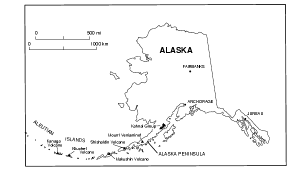
Figure 1. Locations of Alaskan volcanoes (triangles) mentioned in this report.Mount Martin is a large, mostly ice-covered stratovolcano in the Katmai Group, located within Katmai National Park and Preserve on the Alaska Peninsula (fig. 1). A poorly documented record of historical activity indicates two possible minor eruptions this century. Steam emission from the 500-meter-wide summit crater is vigorous and nearly continuous with plumes occasionally rising 600 m or more above the vent and extending downwind for up to 20 km.
On Wednesday, March 15, 1995, the National Weather Service (NWS) received a report that residents in King Salmon, located 92 km (57 mi) to the northwest observed steam plumes rising 600-900 m (2000-3000 ft) over the general vicinity of Mount Martin. No indication of eruptive activity was detected on satellite imagery. The incident was reported in the AVO weekly update of March 17, 1995, and the Global Volcanism Network (GVN) bulletin (Smithsonian Institution, 1995a).
AVO responded by gathering observer accounts of the steam plumes, analyzing satellite images in conjunction with NWS, and fielding calls from air carriers. [Note, the Katmai seismic net was not operating at this time; the real-time network came online in August, 1995.]
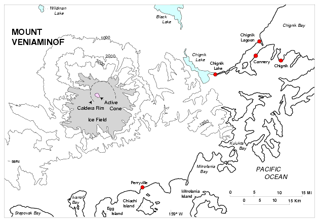
Mount Veniaminof is a composite stratocone located on the Alaska Peninsula about 800 km (500 mi) southwest of Anchorage. The volcano is truncated by an ice-filled summit caldera 8 x 11 km (5 x 7 mi) in diameter (fig. 2). Two cinder cones protrude through the ice-cap, one of which has been the locus of frequent historical eruptive activity at Mount Veniaminof. The current eruptive episode appears to be quite similar in style and magnitude to the 1983-84 eruption of Mount Veniaminof (Yount and others, 1985). The nearest settlements are Perryville, 34 km/21 mi SE, and Chignik Lake, Chignik Lagoon and Chignik, 40 km/25 mi, 55 km/34 km, and 60 km/37 mi ENE of the volcano, respectively (fig. 2). The village of Meshik/Port Heiden is on the Bering Sea coast 96 km (60 mi) NE of Mount Veniaminof.
Figure 2. Map of Mount Veniaminof and surrounding area. For clarity, only selected contours (contour interval = 1000 ft) are shown.The most recent eruption began July 30, 1993 from the main intracaldera cinder cone and was characterized by intermittent minor steam and ash emission and extrusion of a lava flow, which melted a large pit (1000 m x 800 m) in the summit ice cap (Neal and others, 1995a). The eruptive activity appeared to diminish by the end of the 1994 summer, however, AVHRR satellite images continued to frequently record thermal anomalies throughout the fall and into the first several months of 1995; the anomalies were interpreted to be related to the cooling lava flow.
In mid-April, 1995, reports from observers in Perryville and Port Heiden of small dark plumes over Veniaminof coincided with thermal anomalies near the active vent recorded on satellite images (Smithsonian Institution, 1995b). This low-level activity was interpreted to result from interaction of lava with ice and snow causing occasional low-energy ash bursts and steam generation (Smithsonian Institution, 1995c). Perryville residents heard rumblings and booms and witnessed minor ash emission on November 15, 1995, as reported in the last AVO weekly update that included Veniaminof (12-1-95). Summit hot spots were visible on satellite images of November 2, 8, and 17, 1995. No activity was reported in December.
AVO's response was to make weekly phone calls to resident observers in Perryville and Port Heiden, routinely analyze satellite images, and investigate pilot reports for information about the eruptive activity. The low-level character of the activity that occurred in 1995 apparently posed no significant hazard to aircraft or local residents.
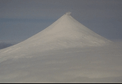
Shishaldin Volcano, located about 1,100 km (680 mi) southwest of Anchorage near the center of Unimak Island, is a spectacular symmetric stratocone (fig. 3) and is the highest peak in the Aleutian Islands. Shishaldin is one of the most active volcanoes in the Aleutian arc with at least 27 eruptions since 1775 (McGimsey and Miller, 1995). The last eruptive period occurred in 1986-87 and consisted of steam and minor ash emission. Strombolian eruptions and ash and steam emissions characterize most of the documented eruptive activity at Shishaldin Volcano. Nearly constant fumarolic activity within the summit crater produces a steam plume that can occasionally be quite vigorous and typically results in numerous false eruption reports. The nearest community is False Pass, 32 km (20 mi) east-northeast of the volcano.
Figure 3. Symmetric Shishaldin Volcano rising 2,857 m (9373 ft) above sea level. Fumarolic activity within the summit crater produces a nearly continuous plume of steam. Photograph by C. Nye, Alaska Division of Geological and Geophysical Surveys, 5/9/94.Around 6:30 pm AST (0330 UTC) on December 23, 1995, the FAA received a pilot report that Shishaldin had apparently erupted, sending an ash cloud to 35,000 feet ASL with prevailing winds carrying the plume to the north and northwest. AVO analysis of a satellite image taken at 7 pm AST revealed a possible small ash plume extending about 50 km northwest from the volcano. A resident of Cold Bay, 90 km (56 mi) northeast of Shishaldin, reported that a very light dusting of ash may have occurred about 1:30 am AST the next morning, December 24. However, low-level winds indicated transport from the southeast, which would have taken ash into the Bering Sea away from Cold Bay. The ash plume observed on satellite imagery dissipated by mid-day on December 24.
At 10:30 am AST on December 24, a pilot departing Dutch Harbor, 200 km (120 mi) southwest of the volcano, reported seeing steam only--no ash--from the summit of Shishaldin. U.S. Coast Guard (USCG) C-130 pilots, familiar with Shishaldin, flying on routine patrol circled the volcano on the afternoon of December 24 and reported the summit crater to be vigorously steaming, no ash on the flanks, and no other obvious signs of eruptive activity; they noted that sulfur deposits that characterize the crater rim were unchanged.
This eruptive activity appears to be similar to that documented in 1993 (Neal and others, 1995b), and 1994 (Neal and others, 1995a).
AVO's response to this incident involved gathering observation information from FAA (pilot reports), analysis of satellite images in conjunction with NWS, and communication with the Coast Guard and local air carriers in Cold Bay and Dutch Harbor. Calls were placed to observers in Port Heiden, Cold Bay, and False Pass. AVO issued an initial update on Sunday, December 24, and summarized the activity in the weekly update on Friday, December 29, 1995. Satellite images of the Shishaldin area continue to be routinely scrutinized for signs of eruptive activity.
Makushin is a broad, ice-capped stratovolcano located about 1,310 km (815 mi) southwest of Anchorage on Unalaska Island in the eastern Aleutian Island chain. The summit is truncated by a 3-km-wide, breached caldera containing a small cinder cone, eroded remnants of other cones, and several fumaroles. The volcano has had frequent minor steam and ash emissions since its discovery in 1763, but no major eruptions have occurred since 1826. The community of Unalaska and port of Dutch Harbor--commerce and transportation hubs of the eastern Aleutians--are located 25 km (16 mi) east of the volcano.
At 12:46 pm AST on Monday, January 30, 1995, USCG C-130 pilots reported a small steam and ash cloud from Makushin Volcano. The cloud rose to about 2400 m (8000 ft) and was carried northeast from the volcano, prompting NWS to issue a SIGMET that ran until 5 pm AST. Over the next hour, several pilots reported seeing a dispersing light brown ash plume at Makushin. All activity subsided shortly thereafter as confirmed by a satellite image recorded at 1:45 pm AST, which showed no sign of the eruption.
AVO responded by gathering observation data from NWS and the Coast Guard (pilot reports) and analyzing satellite images in conjunction with NWS. AVO followed-up inquiries from a major air carrier with a return call to summarize the activity.
Kliuchef, located on the northern rim of Atka caldera, is one of a cluster of stratocones that form the northern part of Atka Island in the central Aleutians. Korovin lies 6 km (3.7 mi) to the north. Most of the minor historical eruptive activity on Atka Island is attributed to Korovin and neighboring Kliuchef. The last documented activity involved plumes from Korovin recorded on satellite images March 18, 1987 (Smithsonian Institution, 1987).
Observers in the village of Atka, located 15 km (9 mi) to the south, reported a very strong sulfur smell on Monday, May 1, and a substantial, but lesser, sulfur smell on Thursday, May 4 coincident with the sighting of a small plume-like cloud over Kliuchef volcano. Inclement weather on May 1 prevented direct observation of the volcano. The plumes did not appear on satellite images AVO analyzed that week. The smell of sulfur has been reported previously in Atka village, however, the odors in May were regarded as particularly strong. Satellite images on May 3 showed a hot spot on Korovin, possibly corresponding to one of the fumarolic fields.
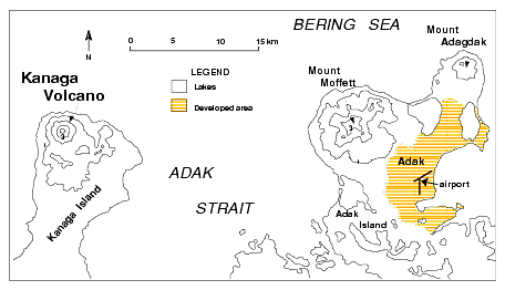
Kanaga Volcano is a symmetric stratocone located on the northern end of Kanaga Island in the western Aleutian Islands, 33 km (21 mi) west of the community of Adak (fig. 4). Numerous eruptions have been recorded since the mid-1700s. The last significant eruption was in 1906 when a series of lava flows advanced down the northeast and southwest flanks. The community of Adak is largely military and the 1994 population of about two thousand at mid-summer is rapidly diminishing with ongoing reductions in the U.S. Navy presence on Adak Island.
Figure 4. Sketch map of portions of Kanaga and Adak Islands. Contour interval 1000 ft. Approximate limits of the community of Adak taken from the 1957 edition of USGS topographic map Adak, Alaska (Alaska Topographic Series, scale 1:250,000).The most recent eruption of Kanaga began in mid-1993 and has continued intermittently through most of 1995. The eruption in 1993-1994 was characterized by steam and ash plumes rising to as high as 7.5 km (24,600 ft.) and drifting a few tens of kilometers downwind, lava extrusion within the summit crater, and minor avalanching of incandescent debris down the north flank, some of which reached the sea (Neal and others, 1995a, b). Based on satellite and ground-based observations, the eruption had significantly waned or ceased by late November, 1994. However, weather conditions in the Aleutians typically prevent direct observations for days or weeks at a time, and over the next six months, during breaks in the weather, observers in Adak continued to report minor steam plumes above the summit of Kanaga (Smithsonian Institution, 1995d).
On June 3-4, 1995, U.S. Fish and Wildlife Service (USFWS) personnel aboard the research vessel Tiglax observed steaming from the summit and from the area covered by 1994 avalanche deposits on the north flank. Two weeks later, on June 19, a pilot reported seeing possible fresh ash or bare ground due to snow-melt on the west flank, and a weak ash plume up to 300 m (1000 ft.) above the summit. An AVHRR satellite image from June 21 showed a steam plume extended north from Kanaga (fig. 5).
_
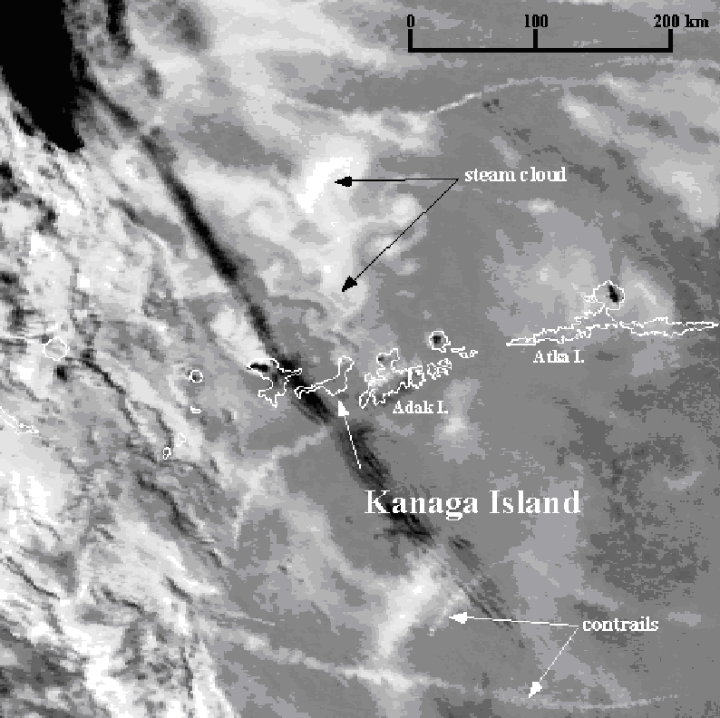 Figure 5. AVHRR band 3 image taken at 1849 UT on June 21, 1995, shows a steam plume >160 km (100 mi) long drifting north from Kanaga Volcano. White is warm and dark is cold.
The following day, another pilot reported a dirty haze at summit elevation extending 25 km south. AVHRR satellite images recorded a few hours later confirmed a weak thermal anomaly at the summit and a plume extending about 180 km to the north, prompting AVO to issue an information release stating that a small eruption may have occurred at Kanaga. On June 23, the U.S. Navy Meteorological Office in Adak reported a thin ash cloud at the summit. USCG C-130 pilots observed a dusting of ash on the flank and 3 active steam vents on the south flank (Smithsonian Institution, 1995e). Poor weather prevented observation of the volcano for much of the next 2 months. Occasional observations from Adak confirmed that vigorous fumarolic activity continued high on the southeast flank and minor steaming was still occurring at the summit crater (Smithsonian Institution, 1995f).
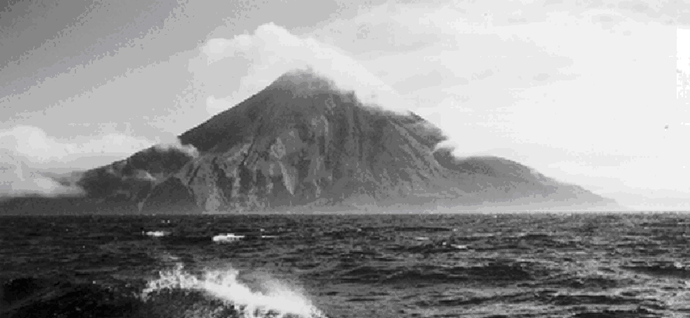
The captain of the USFWS research vessel Tiglax (Kevin Bell) reported in mid-October that on October 1 he observed hot blocks cascading down ravines on the north and northwest flank from near the summit--which was obscured by clouds--to as far as sea level, leaving "steaming contrails" in their wakes (fig. 6). He noted that the activity was similar to that which he had observed during the documented eruptive period of summer 1994, and that the activity would not have been visible from Adak. However, based on the lack of a corresponding satellite-image anomaly or an ash plume visible from Adak, AVO concluded that Kanaga was probably not erupting at that time; what the Tiglax captain witnessed was most likely the continued avalanching of unstable lava masses that accumulated on the northwest flank during 1993-94.
No further activity was reported by pilots or ground observers, and no thermal anomalies were visible on satellite imagery for the remainder of 1995. The last 1995 AVO weekly update to include Kanaga was that of August 25.
AVO's response to the ongoing eruptive activity at Kanaga has been to closely monitor satellite images, collect pilot and shipcrew reports, make weekly calls to USFWS and U.S. Navy observers in Adak, consult frequently with NWS, FAA, and the USCG, and summarize information in weekly updates.
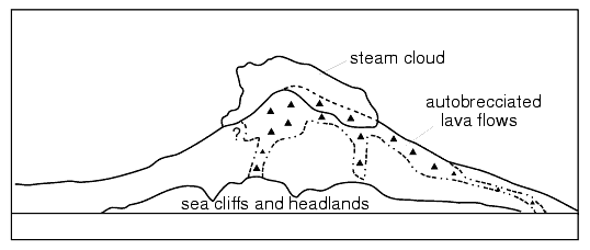
Figure 6. North flank of Kanaga Volcano where hot debris intermittently cascaded to the sea during the most recent eruptive period. Photo by Kevin Bell, USFWS, 10-1-95. Extent of lava flows is based on Bell's annotations.

![]() U.S. Department of the Interior |
U.S. Geological Survey
U.S. Department of the Interior |
U.S. Geological Survey
URL: http://pubsdata.usgs.gov/pubs/of/1996/0738/alaska.html
Page Contact Information: GS Pubs Web Contact
Page Last Modified: Wednesday, 07-Dec-2016 16:07:51 EST