
By USGS Auburn Project Review Team 1
U.S. Geological Survey Open File Report 96-0011
At the Auburn Dam site geologic deposits that could be used to constrain the amount of displacement per event on faults that passed directly beneath the dam foundation were absent. Therefore, the 9-inch design displacement was developed principally from observations made in paleoseismic trenches excavated across many faults in the western Sierran foothills as part of geologic studies for projects such as the New Melones Dam and the proposed Stanislaus nuclear power plant, as well as for the Auburn Dam. In these trench exposures the maximum observed vertical displacement of a regionally developed soil horizon (termed the "paleo B" and assumed to be approximately 100,000 years old) was 2 feet, and the net displacement across this soil was estimated to be 2.4 feet when an oblique component of slip was added (WCC, 1977). Structural and stratigraphic relations in several of the exploration trenches suggested that the net displacement on the paleo B soil was incremental and resulted from repeated earthquakes. However, there were no consistent measurements of the actual amount of displacement during individual earthquakes. WCC (1977) concluded that the 2.4 feet of offset resulted from at least three earthquakes. This interpretation, plus a number of assumptions, yielded a value of 0.8 feet (9.6 inches) as the maximum net displacement per event that could occur on a fault in the western Sierran foothills, including the faults in the dam foundation. In 1979 the State of California proposed essentially the same value, 9 inches, which became the design basis displacement.
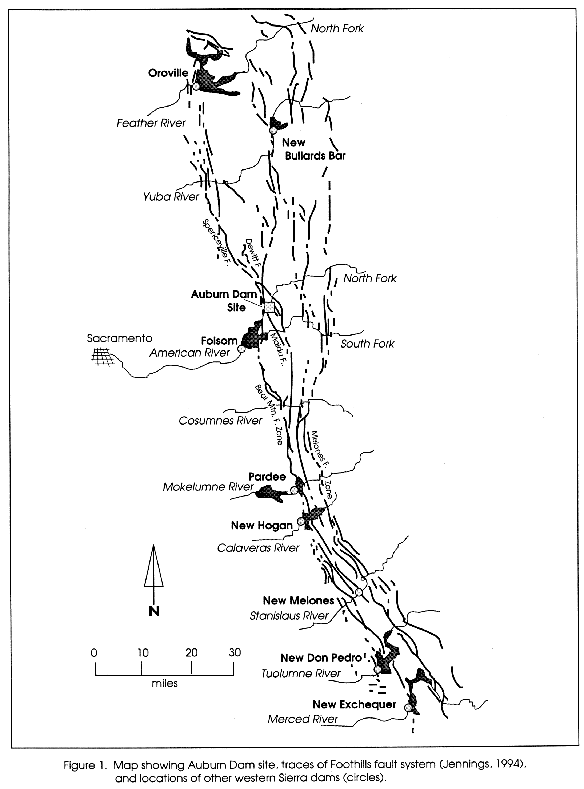
How reasonable is the 9-inch value in light of geological work conducted in the Sierran foothills since 1979 and our present understanding of surface faulting? Recent studies of potentially active faults have been completed by PG&E (1994) for the Rock Creek Dam just north of Auburn and by the Corps (1995) for the New Hogan reservoir on the Calaveras River (Figure 1). Trenching of the Dewitt fault, Deadman fault, and Highway 49 fault near Auburn and the Waters Peak fault and Ione fault near the New Hogan reservoir shows that each of these faults displays evidence of movement characterized by relatively small (less than 2.5 feet) long- term displacements of the paleo B soil and other geologic deposits in the past 100,000 years. These new studies still do not clearly quantify the amount of displacement during individual surface faulting earthquakes, although trenches across the Dewitt fault (Figure 1) at a site six miles northwest of the Auburn Dam site exposed stratigraphic separation of a colluvium younger than the paleo B soil that can be interpreted, at this one location, as a single-event displacement of up to 40 cm (15 inches) (PG&E, 1994).
Detailed mapping of surface faulting earthquakes worldwide since 1979 (for example 1980 El Asnam, Algeria; 1983 Borah Peak, Idaho; 1992 Landers, Calif.) as well as extensive trenching of active faults in the United States and other countries reinforce the observations that (a) surface displacement varies along the length of a rupture and (b) a large percentage of the surface rupture length expresses the average rather than the maximum displacement (Wells and Coppersmith, 1994). Therefore trench observations of surface fault displacement in the western Sierran foothills, which have been made at widely spaced trench locations, are more likely to reflect average rather than maximum values.
Since 1979 there has also been significant growth in the dataset used to derive statistical relations between earthquake magnitude and fault displacement, fault length, and fault area (Wells and Coppersmith, 1994). These relations are most commonly used to estimate earthquake magnitude from field fault parameters (see discussion below). However, they can also be used to estimate fault parameter values for a specific magnitude earthquake. If, for example, it is assumed that the hypocenter for the proposed maximum earthquake for ground motion (presently M6.5) occurs on a fault passing through the dam foundation, the statistical relations yield: a) a mean value for average displacement of 48 cm (l9 inches) with a range of 39 cm to 60 cm (15 inches to 24 inches) and b) a mean value for maximum displacement of 74 cm (29 inches) with a range of 60 cm to 92 cm (24 inches to 36 inches). It should be noted that the magnitude versus displacement relation has a larger standard deviation and smaller correlation coefficient than relations between magnitude and length or area (Wells and Coppersmith, 1994). We emphasize that these values are not necessarily those that should be required for design. They simply show that displacements exceeding 9 inches can be calculated using other approaches.
In summary, recent investigations of faults in the Foothills fault system show that cumulative late Quaternary displacements of 2 to 3 feet observed in soils and other geologic deposits are consistent with previous observations. These new field data continue to suggest that during the past 100,000 years displacement rates are low and displacements of a few tens of centimeters per event are reasonable estimates for many of the faults in the western Sierran foothills. However, neither the pre- nor post-1979 field data precisely define the maximum displacement per event. In 1979 a single value was selected for the maximum displacement. In present seismic hazard practice a strong effort is made to identify and incorporate uncertainty into design values. Therefore, alternative interpretations of field observations and alternative tectonic and fault behavior models can be considered, weighted, and combined to derive a design value and the uncertainty associated with it. There is a basis for estimating a range of potential maximum displacements at the Auburn Dam site, and a design value larger than 9 inches may need to be considered. We recommend that the design displacement be reevaluated.
In 1979 the size of the maximum earthquake was based primarily on a) the statistical relations that had been established at that time between surface wave magnitude (Ms) and fault displacement and length (Slemmons, 1977) and b) a comparison between estimates of fault length and displacement per event on faults in the Sierran foothills and Auburn area with parameters of historical Sierran events such as the 1975 Oroville earthquake. For ground motion analysis, this maximum earthquake was assumed to occur on a fault traversing the dam foundation. Using the maximum displacement of 0.8 feet (24 cm), a length of 10 miles (16 km) as a typical rupture length for a western Sierran foothills fault, and observations from the Oroville earthquake, WCC (1977) estimated that the maximum earthquake on a fault in the western Sierran foothills was 6-6 1/2. The use of "6 1/2" rather than "6.5" was an expression of the uncertainty in the precision of the upper end of the estimate. The USGS (1978) noted that because of scatter in the dataset for the statistical relations these fault parameters gave "expected" rather than "maximum" magnitudes and showed that higher magnitudes could be calculated using the observed fault parameters.
Wells and Coppersmith (1994) have developed new and more robust statistical relations between earthquake magnitude and fault displacement, fault rupture length, and fault area, and they have quantified the inherent variability in the statistical regressions. These relations use moment magnitude (M) in place of surface wave magnitude (Ms), but in the magnitude range of interest for design ground motions at the Auburn Dam site M and Ms are essentially equivalent. Calculating the "maximum" magnitude that a fault can produce involves geologically and seismologically estimating the best maximum value for a fault rupture parameter such as length, displacement per event, and area. The use of a maximum fault parameter value in the statistical relations gives a mean value or "expected" maximum earthquake. Because there is variability or scatter associated with the statistical relations, both higher and lower magnitude estimates are possible for the same rupture parameter. This variability is +0.2 to +0.4 magnitude units depending on which statistical regression is used (Wells and Coppersmith, 1994). Within the earthquake hazard community there is also ongoing discussion of the definition and use of terms such as "maximum" earthquake, "expected" earthquake, and "characteristic" earthquake and these are often used interchangeably.
Estimates of fault parameter values from field observations also contribute to uncertainties in calculating maximum magnitudes. The most commonly used parameter is rupture length, which is now generally derived from fault segmentation modeling. Since 1979 fault segmentation has emerged as a field of earthquake research with important applications for evaluating seismic hazard (Schwartz and Coppersmith, 1986; Schwartz, 1988; Working Group, 1990; Working Group, 1995)), particularly the identification of individual rupture segments of future earthquakes. In the western Sierran foothills fault segmentation modeling is complicated by the absence of widespread youthful geologic deposits that are helpful in defining the lateral continuity of the most recently active fault traces. However, a variety of geomorphic, stratigraphic, and structural evidence in the foothills appears to be useful in delineating segments of late Cenozic faults which, because of repeated long-term movements, have a better chance of being preserved in this geologic environment (Savage and others, 1991). PG&E (1994) suggests that mapped lengths of late Cenozoic faults in the western foothills closely approximate the lengths of seismogenic faulting. They also suggest that long multiple-segment ruptures are not to be expected because long rupture lengths appear to scale with large displacements (Scholz, 1990), and the observed displacements are generally small. These interpretations are reasonable, although recent earthquakes such as the 1992 Landers event show that segmentation can be complex and that surface ruptures during a single earthquake can involve several geometric fault segments.
In seismic hazard investigations for the Rock Creek Dam PG&E (1994) estimated maximum earthquakes for faults in the Auburn area just north of the proposed Auburn Dam site. Using new field observations and estimates of displacement and fault length, and the updated statistical relations, they conclude that the maximum earthquake on the Spenceville fault (located eight miles northwest of Auburn, Figure 1) is 6.4 and the maximum earthquake on the Dewitt fault (located two miles northwest of Auburn at its closest approach, Figure 1) is 6.1 -6.3. For comparison we have used the Wells and Coppersmith (1994) relations and the 1979 Auburn Dam maximum displacement (9 inches) and fault length (10 miles) values to calculate M 6.2 and M 6.5, respectively.
In summary, the maximum earthquake magnitude for ground motions at the dam site in 1979 was a single value of M 6.5. We have noted that there is variability in the statistical relations that are now used to calculate maximum magnitude. This statistical uncertainty is better understood and quantified than in 1979. There are also uncertainties in the field interpretations of fault rupture parameters, particularly fault length, that can be reexamined in light of present concepts of fault segmentation. There are no data to indicate a significant change is necessary in the use of M 6.5 to estimate design ground motions at the dam site. However, there is a basis or estimating a range of potential maximum magnitudes, both higher and lower, using recent field information and the updated statistical fault relations. As discussed, present day seismic hazard analysis can take into account and make use of alternative models, observations, and interpretations. We recommend reevaluating the maximum earthquake magnitude using updated seismic hazard methodology.
We choose two sets of equations to compare with the design value for peak horizontal acceleration. The design value (0.64 g) is larger than the median value (0.56 g) given by the equations of Campbell and Bozorgnia (1994) for a magnitude 6.5 earthquake at zero horizontal distance at a hard-rock site but smaller than the median value (0.73 g) given by the equations of Abrahamson and Silva (written communication, 1995) for a magnitude 6.5 earthquake at zero distance at a rock site.
There are fewer sets of equations available to compare with the design value for peak vertical acceleration, but again we choose two. The design value (0.39 g) is somewhat smaller than the median value (0.45 g) given by the equations of Abrahamson and Litehiser (1989) for a magnitude 6.5 earthquake at zero distance and smaller than the median value (0.57 g) given by the more recent equations of Abrahamson and Silva (written communication, 1995) for a magnitude 6.5 earthquake at zero distance at a rock site.
In summary, the design value for peak horizontal acceleration is larger than the median value from one of the chosen studies and smaller than the other. The design value for vertical acceleration is somewhat smaller than the median of both the chosen studies. The ground-motion design values for the Auburn Dam should be reevaluated in the light of the large number of strong-motion records acquired since the original evaluations nearly twenty years ago and the significant advances in understanding of ground motion that have been achieved in this time. The reevaluation should take account of recent studies (e.g. Bozorgnia and others, 1995) of the characteristics of short-period vertical ground motions at small source distances. It should also take account of recent studies of ground motion from earthquakes in extensional tectonic regimes (Westaway and Smith, 1989; Spudich and others, 1996). Although we consider it important that the reevaluation be done, we have no reason to believe that any resulting changes in design values will pose serious problems for the design of the dam.