Possible Continuous-Type (Unconventional) Gas Accumulation in Lower Silurian "Clinton" Sands, Medina Group, and the Tuscarora Sandstone in the Appalachian Basin: A Progress Report of 1995 project activities
Robert T. Ryder, Kerry L. Aggen, Robert D. Hettinger, Ben E. Law, John J. Miller, Vito F. Nuccio, William J. Perry, Jr., Stephen E. Prensky, John R. SanFilipo, and Craig J. Wandrey
Open-File Report 96-42
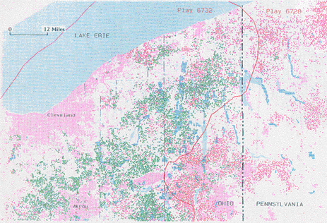
Figure 11. Map of Northeast Ohio and Northwest Pennsylvania showing land use/land cover and hydrocarbon production status by 1/4 sq mi cells for wells penetrating the "Clinton" sand and Medina Group Sandstones.
Explanation for Figure 11.
| Land Use/Land Cover | ||
| pink | Land used for urban, commercial, industrial, and transportation activities | |
| white | Agricultural land | |
| green | Forest land | |
| dark blue | Wetlands | |
| light blue | Lakes, rivers, and reservoirs | |
| gray | Barren lands that include quarries and strip mines | |
| Hydrocarbon Production Status | ||
| Each cell represents a 1/4-mi-square area (cell) that was drilled into or through the Clinton/Medina interval | ||
| X green | Oil | |
| X red | Gas | |
| X purple | Oil and Gas | |
| X black | Nonproductive | |
 |
![]()
![]()
Created by the EERT WWW Staff.
[an error occurred while processing this directive]