
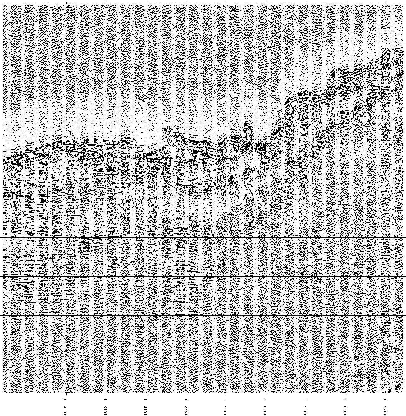
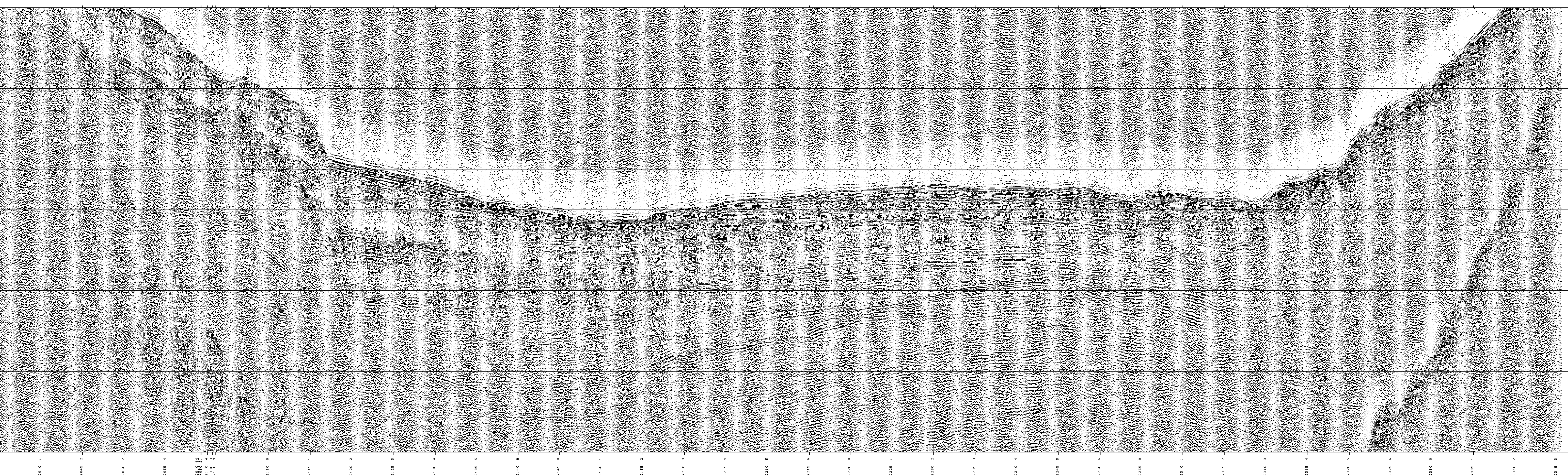
LAKE BAIKAL SEISMIC PROFILES
Annotation as follows:
Line number, depth range, start date (mmddyy or Julian), start and end times.
'Preview' image is quick-loading and fits on a standard browser screen. 'Full
Size' image shows finer detail, including time annotations.
- Upper North Basin
- 1991 Shiptracks
- Line 37a, 1-2 sec, 072491, 15:13-17:10 --
Preview--Full Size
- Line 37b, 1-2 sec, 072491, 17:10-21:13 --
Preview--Full Size
- Line 38, 0.9-1.9 sec, 072491, 21:20-21:46 --
Preview--Full Size
- Line 39, 0.4-1.5 sec, 072491, 21:46-23:43 --
Preview--Full Size
- Lines 40-41, 0.5-1.5 sec, 072591, 15:11-16:54 --
Preview--Full Size
- Line 41, 0.5-1.5 sec, 072591, 16:55-17:53 --
Preview--Full Size
- Line 42, 0.5-1.5 sec, 072591, 17:53-18:57 --
Preview--Full Size
- Line 43, 0.5-1.5 sec, 072591, 18:57-19:47 --
Preview--Full Size
- Line 44, 0.1-1.2 sec, 072591, 19:47-20:36 --
Preview--Full Size
- Line 45a, 0.1-1.2 sec, 072591, 20:36-21:41 --
Preview--Full Size
- Line 45b, 0.5-1.6 sec, 072591, 20:36-23:45 --
Preview--Full Size
- Line 45c, 0.1-1.2 sec, 072591, 23:03-23:45 --
Preview--Full Size
- Line 46, 1-2 sec, 072691, 12:42-14:56 --
Preview--Full Size
- Line 51a, 1-2 sec, 072691, 21:15-23:52 --
Preview--Full Size
- Line 51b, 0-1 sec, 072691, 22:34-23:52 --
Preview--Full Size
- Middle North Basin
- 1991 Shiptracks
- Line 36a, 1-2 sec, 072391, 16:40-19:47 --
Preview--Full Size
- Line 36b, 1-2 sec, 072391, 19:47-23:00 --
Preview--Full Size
- Line 46, 1-2 sec, 072691, 12:42-14:56 --
Preview--Full Size
- Line 47, 1-2 sec, 072691, 14:55-15:54 --
Preview--Full Size
- Line 48, 0.5-1.5 sec, 072691, 15:54-16:51 --
Preview--Full Size
- Line 49, 0.7-1.8 sec, 072691, 16:51-19:30 --
Preview--Full Size
- Line 50, 1-2 sec, 072691, 19:30-21:15 --
Preview--Full Size
- Line 51a, 1-2 sec, 072691, 21:15-23:52 --
Preview--Full Size
- Line 51b, 0-1 sec, 072691, 22:34-23:52 --
Preview--Full Size
- Line 52, 1-2 sec, 072791, 17:06-17:54 --
Preview--Full Size
- Line 53, 0.45-1.55 sec, 072791, 17:54-20:00 --
Preview--Full Size
- Line 54, 0-1 sec, 072791, 20:00-21:01 --
Preview--Full Size
- Line 55a, 0-1 sec, 072791, 21:01-21:26 --
Preview--Full Size
- Line 55b, 1-2 sec, 072791, 21:14-00:32 --
Preview--Full Size
- Line 55c, 0-1 sec, 072891, 00:19-01:01 --
Preview--Full Size
- Line 56a, 1-2 sec, 072891, 13:02-17:19 --
Preview--Full Size
- Line 56b, 0.4-1.5 sec, 072891, 15:54-17:17 --
Preview--Full Size
- Line 57, 0.3-1.4 sec, 072891, 17:19-19:10 --
Preview--Full Size
- Line 58, 1-2 sec, 072891, 19:10-20:44 --
Preview--Full Size
- Line 59, 1-2 sec, 072891, 20:44-22:38 --
Preview--Full Size
- Line 62, 1-2 sec, 073091, 17:22-18:08 --
Preview--Full Size
- Line 63a, 1-2 sec, 073091, 18:08-18:33 --
Preview--Full Size
- Line 63b, 0-1 sec, 073091, 18:33-18:57 --
Preview--Full Size
- Line 64a, 0-1 sec, 073091, 18:57-19:23 --
Preview--Full Size
- Line 64b, 1-2 sec, 073091, 19:23-19:49 --
Preview--Full Size
- Line 65, 1-2 sec, 073091, 19:49-21:59 --
Preview--Full Size
- Line 82a, 1-2 sec, 080391, 14:18-18:55 --
Preview--Full Size
- Academic Ridge
- 1991 Shiptracks
- Line 35a, 0.7-1.8 sec, 072391, 02:13-03:35 --
Preview--Full Size
- Line 35b, 0.4-1.5 sec, 072391, 03:35-05:16 --
Preview--Full Size
- Line 60a, 0-1 sec, 073091, 13:11-14:03 --
Preview--Full Size
- Line 60b, 1-2 sec, 073091, 13:10-16:28 --
Preview--Full Size
- Line 61, 1-2 sec, 073091, 16:28-17:22 --
Preview--Full Size
- Line 62, 1-2 sec, 073091, 17:22-18:08 --
Preview--Full Size
- Line 65, 1-2 sec, 073091, 19:49-21:59 --
Preview--Full Size
- Line 66, 0.5-1.5 sec, 073091, 21:59-00:45 --
Preview--Full Size
- Line 67, 0.5-1.5 sec, 073191, 12:21-13:09 --
Preview--Full Size
- Line 68, 0.5-1.6 sec, 073191, 13:09-14:20 --
Preview--Full Size
- Line 69a, 1-2 sec, 073191, 14:20-16:03 --
Preview--Full Size
- Line 69b, 0.5-1.5 sec, 073191, 16:03-18:31 --
Preview--Full Size
- Line 70, 0-1 sec, 073191, 18:31-20:29 --
Preview--Full Size
- Line 71, 0-1 sec, 073191, 20:29-01:40 --
Preview--Full Size
- Line 72, 0-1 sec, 080191, 13:19-14:21 --
Preview--Full Size
- Line 73, 0-1 sec, 080191, 14:21-15:28 --
Preview--Full Size
- Line 74, 0-1 sec, 080191, 15:28-16:54 --
Preview--Full Size
- Line 75a, 0.3-1.4 sec, 080191, 16:54-18:26 --
Preview--Full Size
- Line 75b, 2-3 sec, 080191, 18:43-19:52 --
Preview--Full Size
- Line 76 -- Digital data not recorded
- Line 77a, 2-3 sec, 080191, 22:19-23:22 --
Preview--Full Size
- Line 77b, 0.3-1.4 sec, 080291, 00:44-03:43 --
Preview--Full Size
- Line 78, 1-2 sec, 080291, 13:23-15:16 --
Preview--Full Size
- Line 79a, 0.6-1.7 sec, 080291, 14:52-18:00 --
Preview--Full Size
- Line 79b, 0-1.0 sec, 080291, 16:23-17:14 --
Preview--Full Size
- Line 80, 0.5-1.5 sec, 080291, 18:00-19:35 --
Preview--Full Size
- Line 81a, 0-1 sec, 080291, 19:35-22:02 --
Preview--Full Size
- Line 81b, 1-2 sec, 080291, 19:35-23:08 --
Preview--Full Size
- Line 82a, 1-2 sec, 080391, 14:18-18:55 --
Preview--Full Size
- Line 82b, 1-2 sec, 080391, 18:41-21:28 --
Preview--Full Size
- Line 82c, 1-2 sec, 080391, 21:27-00:09 --
Preview--Full Size
- 1992 Shiptracks
- Line 22, 0.4-1.5 sec, 208, 03:37-04:30 --
Preview--Full Size
- Line 23 -- Digital data not recorded
- Line 24 -- Digital data not recorded
- Line 25, 0.6-1.7 sec, 208, 09:40-10:12 --
Preview--Full Size
- Line 26, 1-2.1 sec, 208, 10:13-11:02 --
Preview--Full Size
- Line 27, 0.5-1.6 sec, 208, 11:02-13:39 --
Preview--Full Size
- Line 28, 0-1 sec, 208, 13:42-14:39 --
Preview--Full Size
- Line 29, 0-1 sec, 208, 14:39-16:07 --
Preview--Full Size
- Line 30, 0.2-1.3 sec, 208, 16:07-21:31 --
Preview--Full Size
- Line 31, 0-1 sec, 208, 21:31-21:47 --
Preview--Full Size
- Line 32, 0.2-1.2 sec, 208, 21:48-00:21 --
Preview--Full Size
- Line 33, 0.5-1.5 sec, 209, 00:22-01:22 --
Preview--Full Size
- Line 34, 0.5-1.5 sec, 209, 01:22-02:22 --
Preview--Full Size
- Line 35, 0.3-1.3 sec, 209, 02:22-03:54 --
Preview--Full Size
- Line 36, 0.3-1.3 sec, 209, 03:54-04:30 --
Preview--Full Size
- Line 37a, 0.3-1.3 sec, 209, 04:30-06:54 --
Preview--Full Size
- Line 37b, 0.5-1.6 sec, 209, 05:24-06:54 --
Preview--Full Size
- Line 38, 0.6-1.6 sec, 209, 07:03-07:59 --
Preview--Full Size
- Line 39a, 1-2 sec, 209, 07:59-09:15 --
Preview--Full Size
- Line 39b, 0.3-1.4 sec, 209, 08:54-10:00 --
Preview--Full Size
- Line 40, 0.2-1.2 sec, 209, 10:03-10:40 --
Preview--Full Size
- Line 41, 0.2-1.2 sec, 209, 10:40-11:13 --
Preview--Full Size
- Line 42, 0.3-1.3 sec, 209, 11:14-16:24 --
Preview--Full Size
- Line 43 -- Digital data not recorded
- Line 44 -- Digital data not recorded
- Line 45 -- Digital data not recorded
- Line 46 -- Digital data not recorded
- Line 47 -- Digital data not recorded
- Line 48 -- Digital data not recorded
- Line 49 -- Digital data not recorded
- Line 50 -- Digital data not recorded
- Line 51 -- Digital data not recorded
- Line 52, 0-1 sec, 211, 10:10-10:32 --
Preview--Full Size
- Line 53, 0-1 sec, 211, 10:32-11:29 --
Preview--Full Size
- Line 54, 0-1 sec, 211, 11:29-11:54 --
Preview--Full Size
- Line 55, 0-1 sec, 211, 11:54-12:50 --
Preview--Full Size
- Line 56, 0-1 sec, 211, 12:50-13:24 --
Preview--Full Size
- Line 57, 0-1 sec, 211, 13:24-14:20 --
Preview--Full Size
- Line 58, 0-1 sec, 211, 14:20-15:00 --
Preview--Full Size
- Line 59, 0-1 sec, 211, 15:04-15:46 --
Preview--Full Size
- Line 60, 0-1 sec, 211, 15:46-17:35 --
Preview--Full Size
- Selenga Delta
- 1991 Shiptracks
- Line 4, 1-2 sec, 071591, 13:28-19:13 --
Preview--Full Size
- Line 5, 0.5-1.5 sec, 071591, 19:13-20:30 --
Preview--Full Size
- Line 7, 0-1 sec, 071691, 12:45-15:11 --
Preview--Full Size
- Line 8, 0-1 sec, 071691, 15:11-16:48 --
Preview--Full Size
- Line 9a, 0-1 sec, 071691, 16:48-17:41 --
Preview--Full Size
- Line 9b, 1-2 sec, 071691, 17:24-18:47 --
Preview--Full Size
- Line 10a, 1-2 sec, 071691, 18:47-20:15 --
Preview--Full Size
- Line 10b, 0.5-1.5 sec, 071691, 20:22-21:33 --
Preview--Full Size
- Line 11a, 1-2 sec, 071791, 19:21-20:23 --
Preview--Full Size
- Line 11b, 0-1 sec, 071791, 20:01-20:59 --
Preview--Full Size
- Line 12, 0-1 sec, 071791, 21:03-22:16 --
Preview--Full Size
- Line 13a, 0-1 sec, 071791, 22:16-00:21 --
Preview--Full Size
- Line 13b, 1-2 sec, 071891, 00:00-01:11 --
Preview--Full Size
- Line 14, 1-2 sec, 071891, 01:11-02:40 --
Preview--Full Size
- Line 15, 0-1 sec, 071891, 14:54-16:22 --
Preview--Full Size
- Line 16a, 0-1 sec, 071891, 16:22-17:30 --
Preview--Full Size
- Line 16b, 1-2 sec, 071891, 16:57-18:03 --
Preview--Full Size
- Line 17, 1.1-2.1 sec, 071891, 18:03-21:55 --
Preview--Full Size
- Line 18a, 1-2 sec, 071891, 22:10-00:43 --
Preview--Full Size
- Line 18b, 0-1 sec, 071891, 22:50-00:43 --
Preview--Full Size
- Line 19a, 0.4-1.4 sec, 071991, 10:00-10:33 --
Preview--Full Size
- Line 19b, 1-2 sec, 071991, 10:33-11:14 --
Preview--Full Size
- Line 19c, 1-2 sec, 071991, 11:14-12:45 --
Preview--Full Size
- Line 20, 1.1-2.1 sec, 071991, 12:45-13:23 --
Preview--Full Size
- Line 21a, 1.1-2.1 sec, 071991, 13:20-15:45 --
Preview--Full Size
- Line 21b, 0.5-1.5 sec, 071991, 14:15-15:18 --
Preview--Full Size
- Line 22, 1-2 sec, 071991, 15:45-16:28 --
Preview--Full Size
- Line 23, 1.2-2.2 sec, 071991, 16:28-18:10 --
Preview--Full Size
- Line 24, 0.85-1.95 sec, 071991, 18:10-20:05 --
Preview--Full Size
- Line 25, 0-1.1 sec, 072091, 13:37-15:35 --
Preview--Full Size
- Line 26, 0-1.1 sec, 072091, 15:35-16:24 --
Preview--Full Size
- Line 27, 0-1 sec, 072091, 16:24-18:07 --
Preview--Full Size
- Line 28, 0-1 sec, 072091, 18:07-19:11 --
Preview--Full Size
- Line 29, 0-1 sec, 072091, 19:11-20:08 --
Preview--Full Size
- Line 30, 0.2-1.3 sec, 072091, 20:08-22:36 --
Preview--Full Size
- Line 31a, 0.3-1.3 sec, 072091, 22:36-22:57 --
Preview--Full Size
- Line 31b, 1-2 sec, 072091, 22:35-01:05 --
Preview--Full Size
- Line 32 -- Digital data not recorded
- Line 33a, 0-1 sec, 072191, 13:41-14:37 --
Preview--Full Size
- Line 33b, 1-2 sec, 072191, 14:25-15:37 --
Preview--Full Size
- Line 34, 0-1 sec, 072191, 15:37-16:58 --
Preview--Full Size
- Line 83a, 0-1 sec, 080491, 19:19-19:42 --
Preview--Full Size
- Line 83b, 0.6-1.6 sec, 080491, 19:19-20:40 --
Preview--Full Size
- Line 84, 0-1 sec, 080491, 20:55-21:30 --
Preview--Full Size
- Line 85, 0-1 sec, 080491, 21:33-22:07 --
Preview--Full Size
- 1992 Shiptracks
- Line 1, 0-1.1 sec, 205, 09:47-11:04 --
Preview--Full Size
- Line 2 -- Digital data not recorded
- Line 3, 0-1 sec, 205, 11:45-12:56 --Preview
--Full Size
- Line 4, 0-1 sec, 205, 12:57-13:07 --Preview
--Full Size
- Line 5, 0-1.1 sec, 205, 13:07-14:48 --Preview
--Full Size
- Line 6, 0-1 sec, 205, 14:48-15:05 --Preview
--Full Size
- Line 7, 0-1.1 sec, 205, 15:05-16:45 --Preview
--Full Size
- Line 8, 0-1 sec, 205, 16:45-17:00 --Preview
--Full Size
- Line 9, 0.1-1.2 sec, 205, 17:00-18:45 --Preview
--Full Size
- Line 10, 0-1.1 sec, 205, 18:45-20:22 --Preview
--Full Size
- Line 11, 0.5-1.5 sec, 205, 20:23-20:28 --Preview
--Full Size
- Line 12a, 0.4-1.4 sec, 205, 20:28-23:02 --
Preview--Full Size
- Line 12b, 0.8-1.8 sec, 205, 22:06-23:02 --
Preview--Full Size
- Line 13, 1-2 sec, 205, 23:03-23:13 --
Preview--Full Size
- Line 14, 0.5-1.6 sec, 205, 23:13-02:07 --
Preview--Full Size
- Line 15, 0.5-1.6 sec, 206, 02:08-02:28 --
Preview--Full Size
- Line 16a, 0.4-1.5 sec, 206, 02:28-05:42 --
Preview--Full Size
- Line 16b, 1-2 sec, 206, 04:11-07:38 --
Preview--Full Size
- Line 17, 1.2-2.2 sec, 206, 07:38-08:47 --
Preview--Full Size
- Line 18, 1.2-2.2 sec, 206, 08:47-10:35 --
Preview--Full Size
- Line 19a, 1-2.1 sec, 206, 10:35-13:35 --
Preview--Full Size
- Line 19b, 0-1 sec, 206, 13:00-13:35 --
Preview--Full Size
- Line 20a, 0-1.1 sec, 206, 13:45-14:35 --
Preview--Full Size
- Line 20b, 1-2.1 sec, 206, 14:10-15:45 --
Preview--Full Size
- Line 21, 1.5-2.5 sec, 206, 15:48-16:27 --
Preview--Full Size
- Line 65a, 0-1 sec, 213, 11:21-12:23 --
Preview--Full Size
- Line 65b, 0.5-1.5 sec, 213, 11:23-12:23 --
Preview--Full Size
- Line 66, 1-2 sec, 213, 12:23-14:00 --
Preview--Full Size
- Line 67a, 0-1 sec, 213, 14:00-15:07 --
Preview--Full Size
- Line 67b, 0.8-1.8 sec, 213, 14:34-15:45 --
Preview--Full Size
- Line 67c, 1.6-2.6 sec, 213, 15:29-16:53 --
Preview--Full Size
 Go to master lake map
 Return
to Contents
[an error occurred while processing this directive]
Return
to Contents
[an error occurred while processing this directive]