By Marvin M. Abbott, Donna Runkle, and Alan Rea
U.S. Geological Survey Open-File Report 96-443
Prepared in cooperation with the
State of Oklahoma, Office of the Secretary of Environment
Oklahoma City, Oklahoma
1997
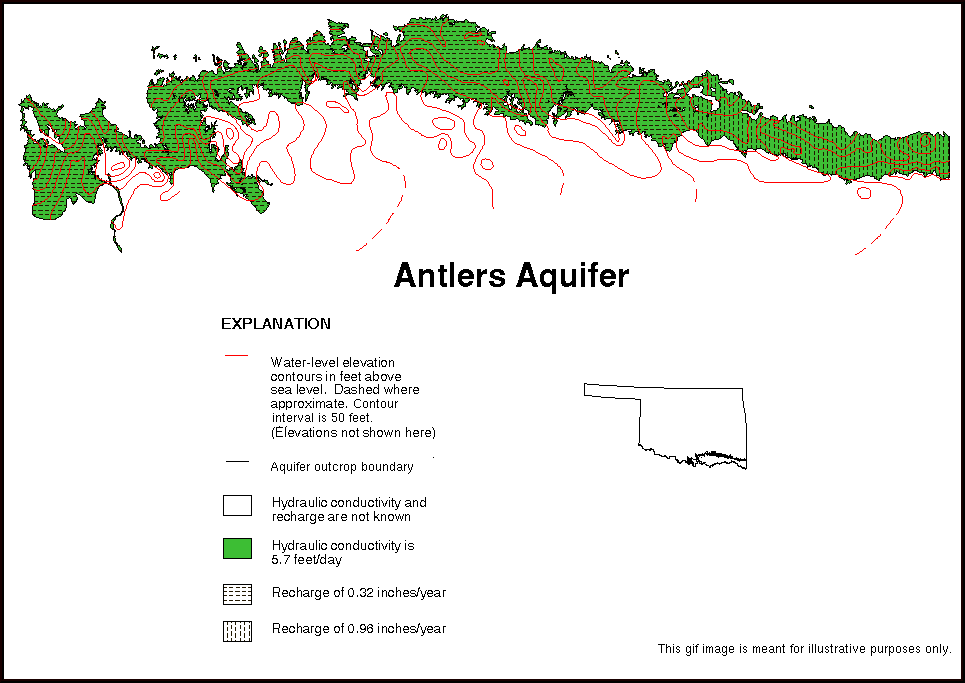
The data sets in this report include digitized aquifer boundaries and maps of hydraulic conductivity, recharge, and ground-water level elevation contours for the Antlers aquifer in southeastern Oklahoma. The Early Cretaceous-age Antlers Sandstone is an important source of water in an area that underlies about 4,400-square miles of all or part of Atoka, Bryan, Carter, Choctaw, Johnston, Love, Marshall, McCurtain, and Pushmataha Counties. The Antlers aquifer consists of sand, clay, conglomerate, and limestone in the outcrop area. The upper part of the Antlers aquifer consists of beds of sand, poorly cemented sandstone, sandy shale, silt, and clay. The Antlers aquifer is unconfined where it outcrops in an area of about 1,800-square miles (Morton, 1992).
The recharge, hydraulic conductivity, and aquifer boundaries data sets include the outcrop area of the Antlers Sandstone in Oklahoma and areas where the Antlers is overlain by alluvial and terrace deposits and a few small thin outcrops of the Goodland Limestone. Most of the lines in the data sets are from the digital data of the surficial geology of the Antlers Sandstone from Cederstrand (1996a, 1996b) except where the Antlers aquifer is overlain by alluvial and terrace deposits near streams and rivers. Morton (1992) interpolated the Antlers aquifer boundaries under the alluvial and terrace deposits where streams cross the aquifer outcrop. Aquifer boundary lines for areas where the aquifer is overlain by alluvial and terrace deposits were digitized and are similar to the aquifer boundaries shown in Morton (1992). A few polygons in this data set represent small and thin outcrops of the Goodland Limestone overlying the Antlers aquifer. The Antlers aquifer in Texas (Morton, 1992) is not included in this data set. The maps from which this data set was derived were scanned or digitized from maps published at a scale of 1:250,000. Hydraulic conductivity and recharge values were used as input to the ground-water model report for the Antlers aquifer by Morton (1992).
The water-level elevation contours were digitized from a mylar map at a scale of 1:250,000 that was used to prepare the final map that was published as plate 1, map A, "Observed potentiometric surface, 1970, Antlers aquifer" at a scale of 1:500,000 in Morton (1992). Morton (1992) used water levels measured in wells in 1970 to construct the map. The water-level elevation contours for the Antlers aquifer in Texas (Morton, 1992) are not included in this data set.
Ground-water flow models are numerical representations that simplify and aggregate natural systems. Models are not unique; different combinations of aquifer characteristics may produce similar results. The hydraulic conductivity and recharge are closely interrelated. As long as these two model inputs are in balance the model has a small mean residual; it represents the natural system numerically. If the hydraulic conductivity is accurately known, the model can be used to accurately determine recharge. Likewise, if the hydraulic conductivity is poorly known, then the recharge will be poorly determined. Therefore, values of hydraulic conductivity and recharge used in the model and presented in this data set are not precise, but are within a reasonable range when compared to independently collected data.
In most aquifers, hydraulic conductivity measurements made in wells or in cores will range over several orders of magnitude, even over short horizontal and vertical distances. Hydraulic conductivity values derived from ground-water flow models represent areal generalizations and do not reflect the large local variance in well or core measurements. Recharge probably varies considerably over the local area, and model recharge is at best an average over an area at least as large as the model grid (and probably much larger than a single cell).
Compilation of the data sets was funded under a cooperative Joint Funding Agreement between the U.S. Geological Survey and the State of Oklahoma, Office of the Secretary of Environment.
These data sets were created for a project to develop data sets to support ground-water vulnerability analysis. The objective was to create and document digital geospatial data sets from published reports or maps, or existing digital geospatial data sets that could be used in ground-water vulnerability analysis.
The data sets provided in this report are available in nonproprietary and ARC/INFO export file formats. (See NOTES section.) Files, except those with ".GIF" or ".GZ" extensions, are ASCII format files.
The data sets stored in the generic, public-domain Digital Line Graph (DLG-3) Version 3, Optional format have file extensions of ".DLG". Designed for data interchange, the DLG-3 format allows the simple creation of a vector polygon or line data structure. The topological linkages are explicitly encoded for node, area, and line elements. The files are composed of 8-bit ASCII characters organized into fixed logical records of 80 bytes. A detailed description of the DLG-3 Optional format may be found in the data users guide 3, Digital Line Graphs from 1:2,000,000-scale maps (U.S. Geological Survey, 1990).
The ARC/INFO export files are ASCII files that utilize a proprietary format. The "NONE" compression option was used with the ARC/INFO EXPORT command. The ARC/INFO export files have file extensions of ".E00".
The data set files have ".GZ" extensions and were compressed for distribution. These files need to be uncompressed to access the digital data. The GUNZIP utility is an MS-DOS executable program that will uncompress the data files. To uncompress a file, type at the MS-DOS prompt:
GUNZIP -aN AQBOUND.GZ
This command will uncompress the file and restore its original name. For example: "AQBOUND.DLG" or "AQBOUND.E00".
A documentation file (known as metadata) is provided for each data set. The documentation files comply with the Federal Geographic Data Committee (FGDC) Content Standards for Digital Geospatial Metadata (Federal Geographic Data Committee, 1994). The FGDC-compliant metadata files contain detailed descriptions of the data sets, and include narrative sections that describe the procedures used to produce the data sets in digital form.
A graphic image also is provided in a Graphics Interchange Format (GIF) file. GIF files are easily displayed on a variety of computer systems that use readily available display software including Internet browser software. This image provides a simplified view of the data sets, and may be used for browsing purposes. The GIF file portrays significantly less spatial resolution and information content than the actual data sets.
No software is provided with these data sets. Users will need GIS software to use the data sets. The U.S. Geological Survey does not recommend or endorse any particular software package for use with these data sets.
The Albers Equal Area map projection (Snyder, 1987) was chosen for the data sets. This projection is appropriate for maps of the conterminous United States because of the visual presentation and equal-area characteristics, which facilitates areal analysis. The projection is cast on the North American Datum of 1983. This projection slightly distorts shapes and distances (scale) in order to maintain equal-area properties. Scale is true along the standard parallels, which are to the north and south of Oklahoma. Scale distortion in Oklahoma reaches a maximum of slightly less than one percent at the northern border of the state. The following table provides map projection information.
| Projection parameters: | |
|---|---|
| Spheroid | GRS1980 |
| Datum | NAD83 |
| First standard parallel | 29 30 00 North |
| Second standard parallel | 45 30 00 North |
| Central meridian | 96 00 00 West |
| Latitude of projection origin | 23 00 00 North |
| Coordinate system parameters: | |
| False easting | 0 |
| False northing | 0 |
| Planimetric units of measure | meters |
Use of trade names is for descriptive purposes only, and does not imply endorsement by the U.S. Government.
ARC/INFO software was used in the development of the data sets. The data sets were processed using the ARC/INFO Revision 7.0.3 software package, running on a Data General AViiON workstation. Further processing was done using ARC/INFO Revisions 7.0.4 and 7.1.1 on a SUN Enterpise 4000 running Solaris Version 2.5.1. File names in this document are enclosed in quotation marks and type set in upper case.
Cederstrand, J.R., 1996a, Digital geologic map of the Ardmore-Sherman quadrangles, south-central Oklahoma: U.S. Geological Survey Open-File Report 96-370, based on a scale of 1:250,000, 3 diskettes. (Available in nonproprietary and ARC/INFO formats.)
Cederstrand, J.R., 1996b, Digital geologic map of McAlester-Texarkana quadrangles, southeastern Oklahoma: U.S. Geological Survey Open-File Report 96-377, based on a scale of 1:250,000, 3 diskettes. (Available in nonproprietary and ARC/INFO formats.)
Federal Geographic Data Committee, 1994, Content standards for digital geospatial metadata (June 8): Federal Geographic Data Committee, Washington, D.C., 78 p.
Morton, R.B., 1992, Simulation of ground-water flow in the Antlers aquifer in southeastern Oklahoma and northeastern Texas: U.S. Geological Survey Water-Resources Investigations Report 88-4208, 22 p.
Snyder, J.P., 1987, Map projections--A working manual: U.S. Geological Survey Professional Paper 1395, 383 p.
U.S. Geological Survey, 1990, Digital line graphs from 1:2,000,000-scale maps, data users guide 3: U.S. Geological Survey National Mapping Program Technical Instruction, 70 p.
| USGS-Oklahoma |
| AccessibilityFOIAPrivacyPolicies and Notices | |
 |
|