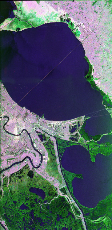
This image of the area surrounding the city of New Orleans, Louisiana in the southeastern United States demonstrates the ability of multi-frequency imaging radar to distinguish different types of land cover. The dark area in the center is Lake Pontchartrain. The thin line running across the lake is a causeway connecting New Orleans to the city of Mandeville. Lake Borgne is the dark area in the lower right of the image. The Mississippi River appears as a dark, wavy line in the lower left. The white dots on the Mississippi are ships. The French Quarter is the brownish square near the left center of the image. The New Orleans Airport is the bright spot near the center, jutting out into Lake Pontchartrain. The image was acquired by the Spaceborne Imaging Radar C/X-Band Synthetic Aperture Radar (SIR-C/X-SAR) during orbit 39 of space shuttle Endeavour on October 2, 1994. The area is located at 30.10 degrees north latitude and 89.1 degrees west longitude. The area shown is approximately 100 kilometers (60 miles) by 50 kilometers (30 miles). The colors in this image were obtained using the following radar channels: red represents the L-band (horizontally transmitted and received); green represents the C-band (horizontally transmitted and received); blue represents the L-band (vertically transmitted and received). The green areas are primarily vegetation consisting of swamp land and swamp forest (bayou) growing on sandy soil, while the pink areas are associated with reflections from buildings in urban and suburban areas. Different tones and colors in the vegetation areas will be studied by scientists to see how effective imaging radar data is in discriminating between different types of wetlands. Accurate maps of coastal wetland areas are important to ecologists studying wild fowl and the coastal environment.
P-45164 February 23, 1995
Users with Internet access may obtain a full-resolution (23.3 megabytes) copy of this image by clicking here.
Spaceborne Imaging Radar-C and X-Band Synthetic Aperture Radar (SIR-C/X-SAR) is part of NASA's Mission to Planet Earth. The radars illuminate Earth with microwaves allowing detailed observations at any time, regardless of weather or sunlight conditions. SIR-C/X-SAR uses three microwave wavelengths: L-band (24 cm), C-band (6 cm) and X-band (3 cm). The multi-frequency data will be used by the international scientific community to better understand the global environment and how it is changing. The SIR-C/X-SAR data, complemented by aircraft and ground studies, will give scientists clearer insights into those environmental changes which are caused by nature and those changes which are induced by human activity. SIR-C was developed by NASA's Jet Propulsion Laboratory. X-SAR was developed by the Dornier and Alenia Spazio companies for the German space agency, Deutsche Agentur fuer Raumfahrtangelegenheiten (DARA), and the Italian space agency, Agenzia Spaziale Italiana (ASI), with the Deutsche Forschungsanstalt fuer Luft und Raumfahrt e.v.(DLR), the major partner in science, operations, and data processing of X-SAR.
[an error occurred while processing this directive]BACK
HOME