USGS Response to an Urban Earthquake -- Northridge '94
The Causes and Effects of Liquefaction, Settlements, and Soil Failures
The Northridge earthquake caused numerous ground-surface failures across
a broad area of southern California. Failures occurred from the southern parts of Los Angeles County to the Kern
County line on the north, and from coastal Ventura County on the west to the southeastern parts of Los Angeles
County. These failures included zones of ground fissures and extensional cracking, lateral displacements, settlements
with vertical displacements, and compressive deformation in the form of soil and pavement warps and buckles. Such
features are common effects of strong earthquakes and warrant scrutiny because of the severe property losses they
inflict. USGS investigators focused on documenting the extent and nature of ground failures, analyzing the impacts
of ground failures on the built environment, and conducting field investigations to clarify the mechanisms of failure.
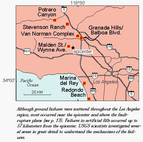
 Although ground failures were scattered throughout the Los Angeles region, most occurred near
the epicenter and above the fault- rupture plane (see p. 13). Failures in artificial fills occurred up to 57 kilometers
from the epicenter. USGS scientists investigated several areas in great detail to understand the mechanisms of
the failures.
Although ground failures were scattered throughout the Los Angeles region, most occurred near
the epicenter and above the fault- rupture plane (see p. 13). Failures in artificial fills occurred up to 57 kilometers
from the epicenter. USGS scientists investigated several areas in great detail to understand the mechanisms of
the failures.
| Ground failure is used here to describe zones of ground cracking,
fissuring, and localized horizontal and vertical permanent ground displacement that can form by a variety of mechanisms
on gently sloping valley floors. Landslides and rockfalls that occur on steep hillside slopes are discussed separately
beginning on p.44. In general, ground failure may be caused by (1) surface rupture along faults, either as a primary
rupture on the seismogenic fault or as a sympathetic rupture; (2) secondary movement on shallow faults;
(3) shaking-induced compaction of natural deposits in sedimentary basins and river valleys, or artificial fills;
and (4)liquefaction of loose sandy sediment. |
Earthquakes and Ground Failures
When large faults rupture and produce earthquakes, they generally deform
the ground surface. Primary surface faulting, such as the 22-kilometer-long surface rupture associated with the
1971 San Fernando earthquake, is the direct effect of movement on a seismogenic, or earthquake-producing
fault. Rupture on nearby faults induced by the primary event (sympathetic rupture) may also produce surface
faulting. Earthquakes can also produce secondary features that look similar to primary surface rupture.
Primary features related to known or suspected faults can be readily studied by geologists and directly linked
with earthquake activity on those faults, while secondary features may be difficult to link to activity on a particular
fault. However, studies of secondary features can provide information on the effects of earthquake shaking at selected
sitesextremely important information for seismic-hazards evaluation that cannot be directly obtained from studying
seismogenic faults alone.
|
Failures Associated with Faults and Folds
No evidence of primary surface rupture associated with the seismogenic
fault was found. Surface ruptures at Potrero Canyon and Stevenson Ranch were located along the hinge of a fold
near where the seismogenic fault projects to the ground surface, but neither occurrence appears to be associated
with the seismogenic fault. The Stevenson Ranch ruptures, a 320-meter-long zone of bedding-plane faulting that
displaced building pads a maximum of 19 centimeters, appear to be related to folding above the blind thrust fault.
In contrast, trenching and strain studies of the 3-kilometer-long belt of ground cracks that formed within Potrero
Canyon indicate that they are shallow features formed in sediments along the margins of the valley. Trenching studies
indicated mechanisms of shallow failure by shaking rather than by secondary tectonic deformation.
The most extensive belt of 1994 ground failures overlies the Mission Hills fault zone in the Granada Hills-Mission
Hills area. Ground cracks displaced the foundations of houses, fractured swimming pools, broke apart sidewalks
and streets, and ruptured utility lines within a belt 5 kilometers long and several hundred meters wide. The deformation
was concentrated in certain areas within the belt and formed complex associations of ground and pavement cracks,
settlements, compressional features such as buckled pavement and tented sidewalks, and offsets of sidewalks and
curbs. The deformation belt nearly abuts the western end of surface faulting produced by the 1971 San Fernando
earthquake. The area of 1994 ground cracks showed that there had been little permanent surface deformation during
the 1971 earthquake; however, some minor cracks were reopened in 1994.
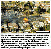
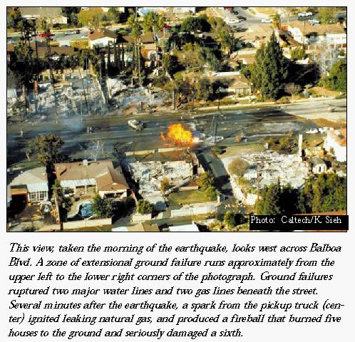
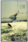
This view, taken the morning of the earthquake, looks west across Balboa Blvd. A zone of extensional ground
failure runs approximately from the upper left to the lower right corners of the photograph. Ground failures ruptured
two major water lines and two gas lines beneath the street. Several minutes after the earthquake, a spark from
the pickup truck (center) ignited leaking natural gas, and produced a fireball that burned five houses to the ground
and seriously damaged a sixth.
The most intensive ground deformation and damage in the Granada Hills-Mission Hills area occurred near Balboa
Blvd., where several zones of tension cracks and a zone of compression (expressed as crumpled pipelines and crushed
pavement) formed in fine-grained alluvium. USGS mapping, trenching, and strain studies in this region showed that
the ground shifted downslope as much as 50 centimeters between the zones of ground extension and compression, and
that the ruptures were shallow features consistent with shaking-induced ground failure.
Subsurface investigations also revealed evidence for a near-surface fault at the southern margin of the deformation
zone near Balboa Blvd. This strand of the Mission Hills fault zone apparently was not active during the earthquake,
nor does it appear to have been significantly active in the last 10,000 years. It appears to localize ground failure
by acting as a ground-water dam in the Balboa Blvd. area. To the east, several zones of ground cracks that coincide
with stream courses filled for housing developments also lie along the fault, as do linear zones of tension cracks
that are observed in bedrock in the Mission Hills. The bedrock cracks are probably from minor landslide movement,
although the possibility of fold-related secondary faulting cannot be ruled out entirely.
 Lessons Learned Lessons Learned
Faults and fold axes appear to be important in localizing ground failure,
although the mechanisms that cause ground failure near fault zones can vary. Some secondary tectonic movement associated
with folding above the blind thrust may have occurred locally, but the effects of these failures are minimal. |
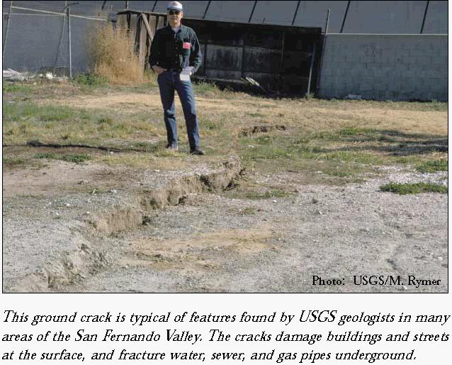
Cracking in Natural Ground
Within the San Fernando Valley, ground cracks that resembled liquefaction-related
lateral spreads and settlements were widespread. Liquefaction could not be confirmed, however, because sand did
not vent to the surface. Failures in nonliquefied areas commonly were underlain by both fine-grained sediments
(silt and clay) and ground water at depths of less than 10 meters. USGS scientists studied two sites in detailMalden
St. and Wynne Ave.. Near Malden St., a 500-meter-long by 20-meter-wide zone of tension cracks and settlements broke
sewers and water pipelines and damaged the foundations of several homes, streets, curbs, and utilities. Curbs and
gutters were displaced 6-10 centimeters, and maximum vertical settlement was about 20 centimeters. At its east
end, the Malden St. zone trended northwesterly and expressed a right-lateral displacement in curbs amounting to
about 17 centimeters. The failures were shallow and resulted from downslope movement of nearly 30 centimeters,
consistent with shaking-induced mechanisms of ground failure. Ground failure at the Wynne Ave. site ruptured both
water and sewer lines, and consisted of a zone of settlement about 150 meters long and 12 meters wide. Permanent
vertical offset across cracks ranged from 10 to 20 centimeters.
Lessons Learned
The Northridge earthquake produced widespread ground failures in areas of
the San Fernando Valley underlain by both ground water and fine-grained sediment (silt and clay) at depths of less
than 10 meters. This empirical association provides a broader basis for identifying areas subject to ground-failure
hazards than by using liquefaction susceptibility. The association of materials and ground-water depths can be
used to identify general areas where site-specific studies of potential ground failure may be advisable. |
Fill Failures
The most widely distributed ground failures appear to be associated with
areas of filled land. Some occurrences were clearly the result of liquefaction, while others lacked direct evidence
for liquefaction. In nearly all cases, however, depth to ground water was less than 10 meters, and any associated
natural deposits were geologically recent.
Fill failures in the San Fernando Valley occurred along the channelized course of Bull Creek, which at many
localities had been filled for development. Settlements at John F. Kennedy High School and on Odessa Ave. north
of Rinaldi St., caused significant damage to structures and buried utilities. Several streets near the epicentral
area exhibited settlement and cracking over known storm drains, and other streets nearby may have been located
over old filled drainages. A small number of ground failures occurred along the Pacific Coast from Santa Monica
to the Port of Los Angeles. These were mainly associated with poorly compacted sandy fills north of the Santa Monica
Pier and near Marina Del Rey. In Redondo Beach, a quay wall moved more than 5 meters laterally due to liquefaction.
Overall, however, ground failure in the coastal areas was modest. Ground failure concentrated in the southeastern
portion of Simi Valley also could be traced to failure of fills, especially fills placed along Simi Arroyo and
along the former courses of its tributaries. Ground failures commonly appeared to involve cracking and differential
settlement of fills and occasional liquefaction in underlying alluvial deposits. The failures caused significant
damage to structures and buried utilities.
Lessons Learned
Poor performance of loose fills continues to pose risks to the built environment.
In the Northridge earthquake, liquefaction in areas of shallow ground water contributed to many fill failures.
Areas of filled land need to be identified and characterized to determine the likelihood of failure during future
earthquakes. |
Ground Failure and the Built Environment
To evaluate the impact of ground failures, USGS investigators compiled
specific locations and descriptions of damage for more than 7,100 structures, 200 leaks in water-distribution lines,
and more than 2,000 significant breaks in sewer lines within a 24-square-kilometer area of Granada Hills-Mission
Hills. This compilation was merged with detailed mapping of ground failure in the heavily damaged region near Balboa
Blvd.
Damage to Underground Utilities
Leaks in water-distribution lines were concentrated within the 5-kilometer-long
zone of ground cracks in the Granada Hills area. More than 45 leaks per square kilometer occurred in this zone.
Near Balboa Blvd., pipe failures exceeded 200 per square kilometer. In contrast, pipe leaks occurred randomly at
a rate of about 4.3 per square kilometer outside the ground-failure zone. Specific locations of pipe leaks closely
match the zones of ground failures, suggesting that water lines tended to break primarily where the ground fractured.
The few failures outside the areas of ground cracking are mainly attributable to corrosion in old pipes, or to
poor welds.
With FEMA funding, the City of Los Angeles has visually assessed, via closed-circuit television, nearly all
of the approximately 275 kilometers of sewer mains within the USGS study area. Sewer pipes are made of extremely
brittle vitreous clay, buried at depths of 1.5-4 meters, and are highly susceptible to structural damage. About
10-20,000 structural defects were observed in pipes within the study area, but most of these were very slight offsets
or minor cracks at joints between pipe sections. These defects are attributable to flexing or pounding at the joints
during the earthquake; however, the defects may have been produced during prior earthquakes, or during construction
and subsequent settlement around the pipes. The more than 2,000 severe sewer defects that might require repair
or replacement, such as cracked and broken joints, joint offsets, and holes or fractures in pipe sections, predominantly
occurred within ground-failure zones. In areas outside these zones, 55 significant defects occurred per square
kilometer, whereas they rose to more than 295 per square kilometer within the ground-failure zone and to more than
1,150 per square kilometer near Balboa Blvd. Generally, extensional and compressional failures in the sewer lines
corresponded closely with earthquake-induced north-south extension and compression of the land surface.
Lessons Learned
Ground failure, rather than ground shaking, is the principal cause of damage
to water and sewer lines. The brittle sewer pipes tended to fail under much lower strains than water lines, so
damage to sewer lines is considerably more extensive. Identifying where and to what degree subgrade utilities are
at risk from earthquakes can be accomplished by accurately delineating regions at risk of ground failure during
earthquake shaking. |
Structural Damage
To investigate the potential significance of ground failure to structural
damage, the USGS examined damage records for single-family residences situated on geologically recent sediments.
Information on costs and types of repairs for damaged homes was compiled from safety inspections made shortly after
the earthquake, and from records of building permits issued for earthquake repairs. Such records were available
for about one-half the total building stock in the study area. Other properties either suffered no reportable earthquake
damage, were repaired without permits, or had not been repaired during the study period.
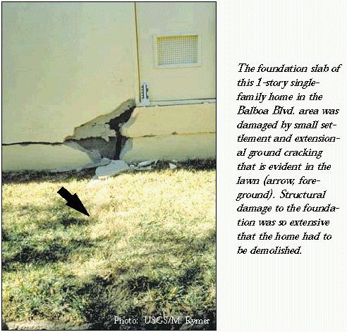
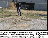
The foundation slab of this 1-story single- family home in the Balboa Blvd. area was damaged by small settlement
and extensional ground cracking that is evident in the lawn (arrow, foreground). Structural damage to the foundation
was so extensive that the home had to be demolished.
In the study area, 4,829 homes experienced some reported property loss and the kinds of required repairs are
known for 2,983 of them. Repair costs for all properties range from $200 to $381,000, averaging $12,193 per property.
However, average repair costs for the 315 properties in areas affected by ground failure were about 300 percent
higher than for the 4,514 properties outside of ground-failure zones. The higher costs in ground-failure zones
were largely due to major foundation repairs, and demolition and replacement of buildings where foundations were
also damaged. Furthermore, most structures that experienced significant losses were typically located on or near
zones of mapped ground cracks.
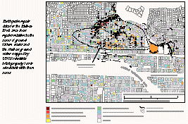
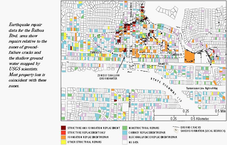
Earthquake repair data for the Balboa Blvd. area show repairs relative to the zones of ground- failure cracks
and the shallow ground water mapped by USGS scientists. Most property loss is coincident with these zones.
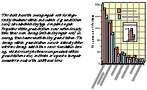
This chart shows the average repair costs for single-family structures within and outside of ground-failure
zones, also subdivided by type of required repair. Properties within ground-failure zones suffered nearly three
times more damage (reflected by repair cost), on average, than houses unaffected by ground failure. The damage
within ground-failure zones is distinctly different from damage outside these zones: foundation damage, which is
nearly six times more prevalent within ground-failure zones, and twice as expensive to repair accounts for most
of the additional losses.
Lessons Learned
Significant losses to single-family homes in ground-failure areas appear
directly attributable to the ground failure itself. Had the Granada Hills-Mission Hills area not been subject to
ground failure in the Northridge earthquake, the resulting damage to structures in that area would likely not have
been much greater than for the northern San Fernando Valley as a whole. These results emphasize the importance
of the ground-failure hazard for future mitigation and research strategies. |
How Does Ground Failure Occur?
USGS scientists evaluated two alternate mechanisms of localized soil failure
and secondary tectonic deformation. Extensive investigations of geotechnical properties of the soils were carried
out at three sites at Balboa Blvd., Malden St. and Wynne Ave. These consisted of borings to determine the geologic
structure and cone-penetration tests to estimate the soil strengths. All three sites were also in areas of gently
sloping ground, and scientists found that they were underlain by saturated soils that could be expected to fail
when subjected to high levels of ground shaking. Therefore, localized failure in a buried layer was thought to
be the mechanism causing the failure at the surface. However, it was not clear that the failures could have been
anticipated even if detailed subsurface investigations had been conducted before the earthquake. Two of the sites,
Balboa Blvd. and Wynne Ave., were underlain by saturated sands that were predicted to liquefy at the levels of
ground shaking recorded in the epicentral region. However, the cracking at Malden St. is suspected to have been
caused by a different mechanism than liquefaction, probably dynamic shear in weak clay. This mechanism should be
more seriously considered in areas underlain by weak soils which may be subjected to high levels of ground shaking.
Secondary tectonic deformation could possibly explain some of the 1994 ground failures at Balboa Blvd. and Wynne
Ave., but USGS scientists consider it unlikely. The stratigraphic complexity and an abrupt change in the depth
to ground water at the south end of the Balboa Blvd. study area suggests the presence of a tectonic fault. However,
the fault does not appear to have significant recent movement, and the 1994 ground-failure zone extends almost
300 meters to the north where no stratigraphic evidence exists for faulting. The 2-meter step on the top of the
sediment observed at Wynne Ave. may have contributed to the location of the ground failure there.
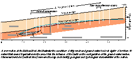
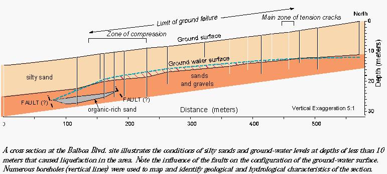
A cross section at the Balboa Blvd. site illustrates the conditions of silty sands and ground-water levels
at depths of less than 10 meters that caused liquefaction in the area. Note the influence of the faults on the
configuration of the ground-water surface. Numerous boreholes (vertical lines) were used to map and identify geological
and hydrological characteristics of the section.
General areas susceptible to ground failure can be delineated on the basis of ground-water levels and geologic
materials of the surface and subsurface. However, it may be difficult to adequately map the subsurface structure
to predict the distribution of ground failure in future earthquakes. Furthermore, scientists have many tools to
predict areas subject to ground failures caused by liquefaction, but predicting specific problem locations will
continue to be challenging. The Northridge earthquake showed, for example, that very strong shaking directly beneath
weak soil sites may cause failures by mechanisms other than liquefaction.
Improving the Soil for Earthquake Resistance
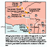
The Northridge earthquake also showed that losses can be reduced by locally increasing the strength of soil
through ground improvement. The Van Norman Complex lies within an area badly damaged by liquefaction-related ground
failure during the 1971 San Fernando earthquake. After 1971, attempts were made to improve soils in parts of the
area because the complex contains several major lifelines and key facilities serving the vast metropolitan areas
to the south. These include major water conveyance, storage, and treatment facilities; electrical generation and
transmission facilities; a solar observatory, a juvenile correctional facility, fuel pipelines, rail lines, and
highways (I-5, I-210, I-405, SH-14, and SH-118). Although the Northridge earthquake produced localized ground failures
that damaged a number of facilities, the overall damage was significantly less than in the 1971 earthquake, despite
higher levels of ground shaking in 1994.
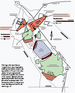
This map of the Van Norman Complex shows where liquefaction-related ground failure occurred during both the
1971 and 1994 earthquakes. Ground displacements recurred in nearly the same areas in 1994; however, displacements
were significantly smaller due to remediation efforts undertaken after 1971. Performance of the Los Angeles and
Lower San Fernando Dams is discussed on p. 67.
The areas of the Joseph Jensen Filtration Plant and the San Fernando Juvenile Hall illustrate the positive aspects
of ground improvement in reducing the severity of ground failure. In 1971, up to 2 meters of ground displacement
damaged Juvenile Hall buildings so severely that they were razed and eventually replaced. The site was excavated
to a depth of about 12 meters and reconstructed with a compacted buttress fill.
Investigation after the Northridge event revealed that some parts of the 1971 failure zone failed again, but
the magnitude of displacement was small enough (less than 8 centimeters) to suggest that remediation measures were
nearly entirely successful. The Joseph Jensen Filtration Plant was under construction on an engineered fill when
the 1971 quake struck. Liquefaction in alluvium under the fill produced about 0.5 meters of lateral displacement
at the main control building, and displacement increased to about 1 meter near Upper Van Norman Lake. Remedial
measures since 1971 included installation of at least 1,100 gravel columns, placed as conduits for ground water
in an effort to mitigate liquefaction. The cumulative width of extensional failures in the fill measured after
the 1994 quake was about 15 centimeters, suggesting considerable success of the remedial efforts in minimizing
the effects of liquefaction.
 Although ground failures were scattered throughout the Los Angeles region, most occurred near
the epicenter and above the fault- rupture plane (see p. 13). Failures in artificial fills occurred up to 57 kilometers
from the epicenter. USGS scientists investigated several areas in great detail to understand the mechanisms of
the failures.
Although ground failures were scattered throughout the Los Angeles region, most occurred near
the epicenter and above the fault- rupture plane (see p. 13). Failures in artificial fills occurred up to 57 kilometers
from the epicenter. USGS scientists investigated several areas in great detail to understand the mechanisms of
the failures.