Open-File Report 96-676
| About USGS / Science Topics / Maps, Products & Publications / Education / Publication: FAQ |
Prepared in cooperation with the Southern Nevada Water Authority and the Virgin Valley Water District

The town of Mesquite, which lies in the center of the map area, is rapidly growing as it is transformed from a small farming and ranching community into a recreation and retirement center. The addition of housing developments, casinos, golf courses, commercial centers, and industrial plants has strained all the infrastructure, and especially the water supply system. Although the Virgin River flows past the town, the quality and quantity of surface water available is insufficient for the needs of the town (Metcalf, 1995). The situation is further complicated because all the land and water east of town is in Arizona whereas the town and most of the population is in Nevada. Consequently the Virgin Valley water district has adopted a program of drilling in the Muddy Creek Formation north and west of town to develop ground-water resources (Johnson, 1995). The Mesquite structural basin contains vast quantities of ground water but also concentrations of gypsum and evaporite minerals that degrade the quality of much of the water. Upwelling of fresh water from the southern Nevada carbonate-aquifer system into the Muddy Creek Formation aquifer system, along faults that offset the base of the Tertiary basin-fill sediments, is one of the factors controlling the distribution of various dissolved solids in the ground water. Although deformation of the Muddy Creek Formation at the surface is relatively mild, geophysical and stratigraphic data indicate that beneath the basin-fill sediments of the Muddy Creek and Horse Springs Formations are limestone and dolomite beds that are severly deformed and faulted (Bohannon and others, 1993). Mapping the detailed nature of deformation and stratigraphy in the Muddy Creek Formation near Mesquite is intended to provide another line of evidence to aid in optimal siting of water-production wells. The information may also have application in siting and designing other facilities and in developing aggregate resources. This report is preliminary and has not been reviewed for conformity with U.S. Geological Survey editorial standards and stratigraphic nomenclature E-mail comments to the author: Van S. Williams (vwilliam@usgs.gov) |
|
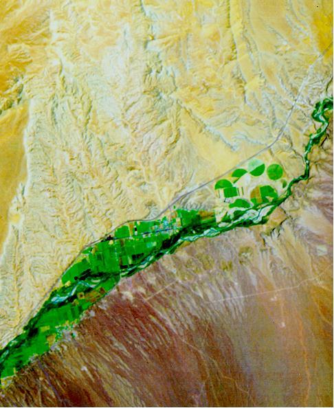
Satellite image of the Mesquite area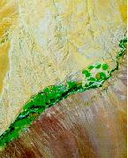
|
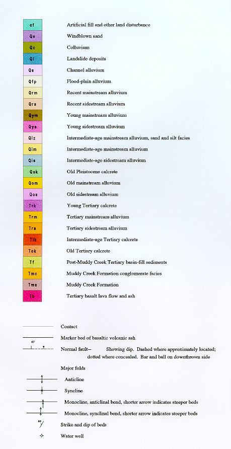
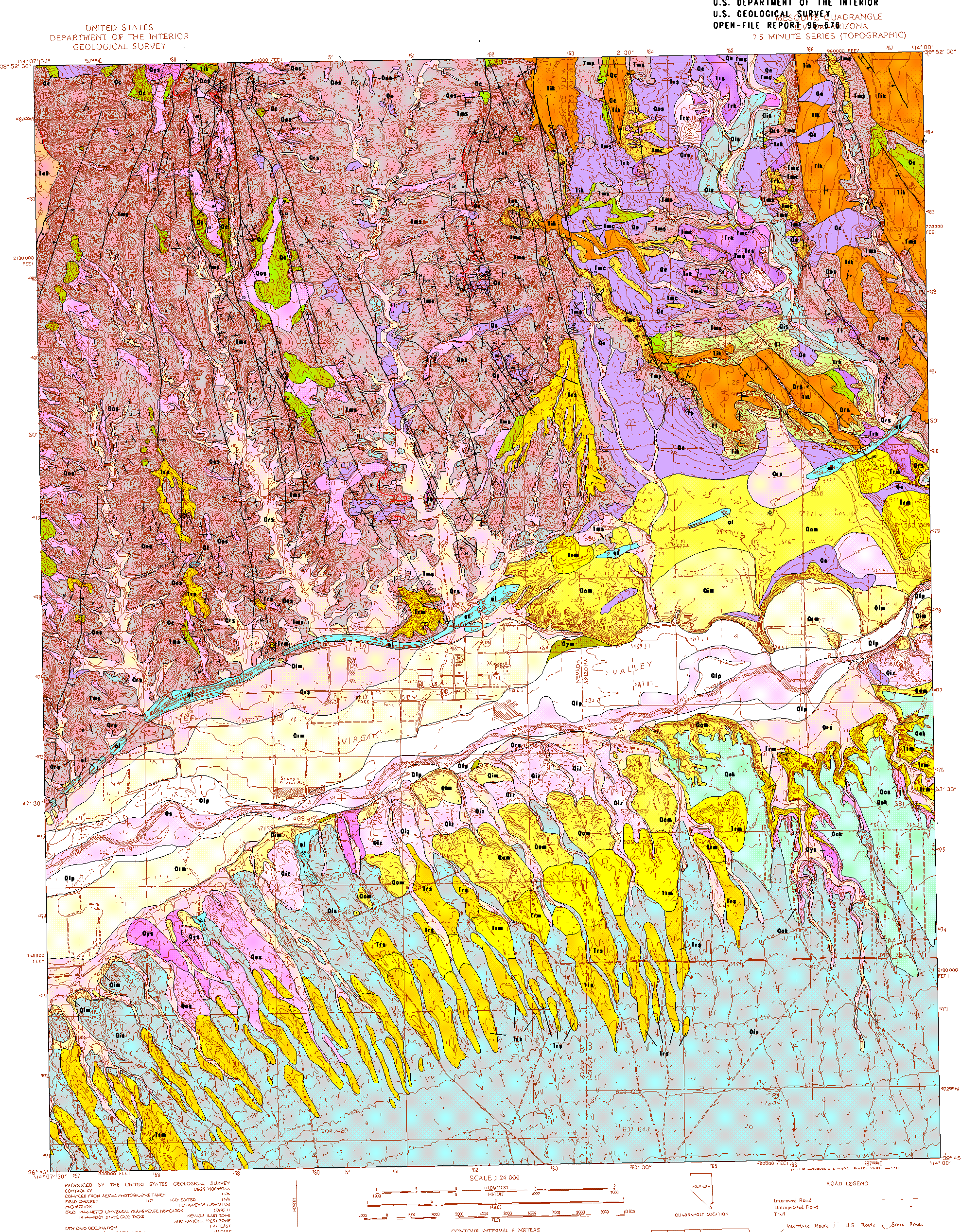
Geologic map of the
|
| Full Screen Image |
|---|
Click on thumbnail or caption for viewing |
| Full Screen Image |
|---|
Click on thumbnail or caption for viewing |

| Full Screen Image |
|---|
Click on thumbnail or caption for viewing |
af |
Artificial fill and other land disturbances--Areas where major excavation or deposition of fill by people has disturbed the land surface to the extent that its pre-existing natural character can not be accurately determined. Comprised primarily of highway right-of-ways, construction sites, and gravel pits. Disturbances after 1976 generally not shown because the pre-existing character can be determined from available air photos. |
||
|---|---|---|---|
Qe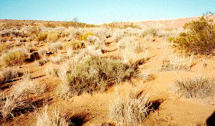
|
Windblown sand (Holocene to late Pleistocene)--Very-pale-orange and yellowish-gray; unconsolidated; well sorted sand, containing no visible bedding. Forms sand sheets and dunes downwind from sandy stream channels and from extensive unvegetated exposures of Muddy Creek Formation (Tms) north of the Virgin River. Locally produced by remobilization of eolian sand beds within the Muddy Creek Formation. Thin sheets of eolian sand mantle most gently-sloping surfaces in the quadrangle but were only mapped where thick enough to have distinctive form and where they obscure underlying material. No soil observed. Average maximum thickness about 2 m. Photo |
||
Qc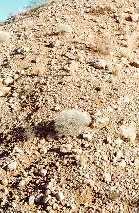
|
Colluvium (Quaternary)--Intermixed slope wash, talus and windblown sand deposits on hill-slopes. Coarse debris consists primarily of calcrete clasts released by erosion of thick Tertiary calcrete soils but deposits may include some sandstone clasts derived from indurated beds in the Muddy Creek Formation (Tms) and locally well rounded siliceous cobbles from conglomerate beds in the Muddy Creek Formation (Tmc). Deposits along the wesßtern edge of the map area were formed on the high escarpment on the east side of Flat Top Mesa but are now inactive and isolated because of erosional retreat of that escarpment. Age mostly late Pleistocene but in places may be as old as early Pleistocene. Equivalent in part to the unit talus deposits (Qt) of Billingsley (1995, Billingsley and Bohannon, 1995) in the adjacent Elbow Canyon and Littlefield quadrangles. Maximum thickness about 10 m. Photo |
||
Ql |
Landslide deposits (Quaternary)--A small rotated block of sandstone from the Muddy Creek Formation sandstone (Tms) on the ridge between Abbot and Pulsipher Washes in the west central part of the map area. Landslide blocks are relatively rare in the map area but are common along the east-facing escarpment of Flat Top Mesa just west of the western map boundary. Thickness about 15 m |
||
Qs |
Channel alluvium of Virgin River (Holocene)--Very-pale-orange, grayish-orange-pink, and moderate-orange-pink, unconsolidated, poorly sorted to well sorted, poorly bedded ,mostly fine to medium sand, silt, and small amounts of gravel. Gravel consists of subangular to subrounded cobbles, pebbles, and boulders of gneiss, granite, pegmatite, quartzite, limestone, and dolomite, and well-rounded clasts of brown quartzite and black and green chert. Unit exposed in sand bars of Virgin River channel and as deposits in abandoned channels within flood-plain deposits along Virgin River. Surface of unit is characterized by bar-and-swale topography. No soil observed. Thickness more than 2 m |
||
Qfp |
Flood-plain alluvium of Virgin River (Holocene)--Very-pale-orange and grayish-orange-pink, unconsolidated, mostly well sorted, poorly bedded, sand and small amounts of gravely sand and gravel. Unit covers about 60 percent of floor of Virgin Valley. Surface of unit is 1-2 m above the Virgin River channel (Qs) and is smooth and covered with a heavy growth of mesquite where the flood plain is not cultivated. Exposed thickness 2 m |
||
Qrm |
Recent mainstream alluvium (Holocene to late Pleistocene?)--Low-terrace alluvium of the Virgin River. Similar to flood-plain alluvium (Qfp) but 2-6 m above Virgin River channel and less susceptible to flooding. Mantled by and grades into recent sidestream alluvium (Qrs) away from the river. 4 m thick |
||
Qrs |
Recent sidestream alluvium (Holocene to late Pleistocene?)--Very-pale-orange to yellowish-gray, unconsolidated, poorly to moderately sorted, poorly to moderately well bedded gravel, sandy gravel, and sand. Gravel consists of angular to rounded clasts of gneiss, granite, pegmatite, quartzite, limestone, and dolomite. Clasts are mostly cobbles and pebbles in size but include boulders as much as 2 m in diameter. Unit includes the active-channel, flood-plain, and low-terrace deposits of minor streams. Channels are commonly braided and terraces are less than 1.5 m above active channels. Surface of unit is characterized by bar-and-swale topography. Most surface clasts lack desert varnish, but some quartzite and fine-grained igneous and metamorphic clasts have dark-brown varnish that was probably inherited from older deposits; light-brown stains on some quartzite clasts may be postdepositional or inherited. No soil development. Equivalent to part of the alluvium of active stream channels (Qas) of Billingsley (1995, Billingsley and Bohannon, 1995) in the adjacent Elbow Canyon and Littlefield quadrangles. Includes alluvium in stream valleys north of the Virgin River that drain the Muddy Creek Formation and alluvium deposited in channels south of the Virgin River that drain alluvial fan surfaces and heterogeneous bedrock exposed in the Virgin Mountains. On the north side of the Virgin River, consists primarily of sand in Abbot and Pulsipher Washes but includes abundant rounded siliceous cobbles eroded from the conglomeratic part of the Muddy Creek Formation (Tmc) in Coon Creek, Sandy Wash, and Town Wash. On the south side of the river, consists primarily of coarse, angular alluvial gravel and boulders from the Virgin Mountains. Contains a variety of sedimentary and metamorphic lithologies but black Proterozoic schist and gneiss are most common. Exposed thickness more than 3 m |
||
Qok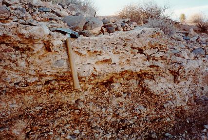
|
Old Pleistocene calcrete (Holocene to early? Pleistocene)--Resistant calcrete soil consisting of a 1-2 m thick stage III-IV carbonate-enriched horizon developed on a surface in the southeastern part of the map area that is cut on old mainstream (Qom), old sidestream (Qos), and Tertiary mainstream (Trm) alluvium. Photo |
||
Trk |
Young Tertiary calcrete (Holocene to upper lower Pliocene)--Carbonate soil developed on Tertiary sidestream (Trs) and Tertiary mainstream alluvium (Trm) and on pediment surfaces graded to these levels. Includes abundant angular to rounded cobbles. The map unit is the youngest and thinnest of the Tertiary calcretes but it still is an old soil that forms a resistant ledge 1 to 2 m thick despite erosional stripping of its upper part. The soil profile is commonly eroded down to near the base of the laminar zone. Where not stripped to bare calcrete, the ground surface is covered by a thin pavement of pebbles and cobbles that include a high percentage of light-colored tabular soil carbonate fragments from the laminar zone. The carbonate soil below the relict laminar zone is completely plugged with aphanitic calcite. The maximum carbonate-soil development is stage V. Not offset by faults or significantly tilted in the map area. Probably equivalent to the carbonate soil developed on regrade gravel of Moapa (Trk) of Schmidt and others (1996) in the Glendale area, 50 km east of the map area. 2-3 m thickness |
||
Tik |
Intermediate-age Tertiary calcrete (Holocene to Pliocene)--Thick calcrete developed on post-Muddy Creek deposits or surfaces. Locally overlies channels of sandy to cobbly alluvium inset into the Muddy Creek Formation or overlies broad areas of gently dipping similar fill (Tf) that bury the steeply dipping Muddy Creek Formation and old Tertiary calcrete (Tok). Includes abundant angular to rounded cobbles. Very resistant to erosion. Soil development probably began after breaching of the Muddy Creek basin threshold but before widespread deep incision. Local incision indicated by the channels may reflect tectonic subsidence in the southern part of the map area. Commonly offset 10's of meters along east-dipping normal faults and tilted as much a 3ー southeasterly. Probably equivalent to the carbonate soil developed on marl of White narrows (Twk) of Schmidt and others (1996) in the Glendale area 50 km east of the map area, and equivalent to the pediment calcrete (Qpc) of Billingsley (1995, Billingsley and Bohannon, 1995) in the adjacent Elbow Canyon and Littlefield quadrangles, although Billingsley has assigned a Quaternary age that reflects the age of a veneer of sediment that locally overlies the soil rather than the period over which the soil formed. Consists of well-indurated stage IV-V pedocalcic horizon 3-5 m thick. |
||
Tok |
Old Tertiary calcrete (Holocene to Miocene?)--Calcrete developed on the highest surfaces in the map area, which were gently sloping pediment surfaces planed on the Muddy Creek Formation (Tms, Tmc). Soil development probably began prior to breaching of the Muddy Creek basin threshold and start of deep incision, estimated to have occurred at about 5 Ma. Consists of a 5-8 m thick stage V pedocalcic horizon that generally lacks clasts larger than small pebbles. Very resistant to erosion. Only three small remnants are preserved above the level of the intermediate Tertiary calcrete in the north central part of the map area, but the old Tertiary calcrete covers an extensive area west of the map area that extends into the map area along the western edge. Occurs buried beneath post-Muddy Creek Tertiary basin-fill sediments (Tf) in the northeastern part of the map area, but those outcrops on cliff faces are mapped as part of the underlying deposit. Equivalent to the well-studied calcrete capping Mormon Mesa (Gardner, 1972a; Machette, 1985) 8 km west of the map area. |
||
Qym |
Young Virgin River alluvium (late Pleistocene)--Very-pale-orange and grayish-orange-pink unconsolidated, mostly well sorted, poorly bedded, sand and small amounts of gravely sand and gravel. Alluvium in this unit contains less gravel than in older terrace deposits (units Trm, Qom, and Qim) but is similar to the alluvium on modern flood plain (Qfp). Along Virgin River, unit is preserved in a few small, isolated terraces that are about 6 m above the channel (Qsc). Exposed thickness more than 6 m |
||
Qys |
Young sidestream alluvium (late Pleistocene)--Identical to recent sidestream alluvium (Qrs) except that it is more deeply incised and locally forms terraces as high as 2 m above the recent sidestream alluvium deposits. Maximum thickness about 4 m |
||
Qim |
Intermediate-age mainstream alluvium (middle Pleistocene)--Pale-red, pale-reddish-brown, and light-brown, poorly sorted, poorly to well bedded, uncemented to well cemented gravel and sandy gravel. Gravel clasts are angular to subrounded gneiss, granite, pegmatite, quartzite, limestone, and dolomite mixed with lesser amounts of well-rounded, light-brown quartzite (Late Proterozoic and Lower Cambrian Prospect Mountain(?) Quartzite) and black and grayish-green chert. Most clasts less than 0.3 m in diameter; maximum clast size 1 m. Stage II carbonate-enriched soil horizon about 1 m thick; no A or B horizon observed but the terrace surface is commonly covered with eolian sand. Forms a terrace at 505 to 515 m altitude, about 30 m above the channel of Virgin River. The preserved terrace surface commonly does not represent the upper limit of deposition but instead is a stripped surface planed by erosion down to the level of the uppermost resistant gravel bed. The thick sequence of sandy, silty alluvium that was deposited over the gravel beds during the last part of the aggradational cycle is locally preserved and has been mapped separately as unit Qiz. The base of the gravel beneath the terrace of the map unit just east of the town of Mesquite was penetrated at about 476 m altitude (37 m depth) in the Palms 3 water well (Michael Johnson, Southern Nevada Water Authority, 1995, oral communication). Correlative to the intermediate terrace alluvium (Qi) mapped by Schmidt and others (1996) in the Glendale area, which in turn is probably correlative with the Lost City terrace alluvium of Gardner (1972b) in the lower Moapa Valley, about 30 km to the west. The intermediate-age mainstream alluvium in this map area is equivalent to the unit high intermediate terrace gravel deposits (Qg4) of Billingsley (1995, Billingsley and Bohannon, 1995) in the adjacent Elbow Canyon and Littlefield quadrangles to the east. Maximum exposed thickness 30 m |
||
Qiz |
Intermediate-age mainstream alluvium, sand and silt facies (middle Pleistocene)--Tan and light-brown sandy, silty alluvium deposited by the Virgin River during the last part of an intermediate-age Pleistocene aggradational episode. It is preserved only where high terraces of resistant gravel upslope have protected it from erosion by sidestreams. Equivalent to the unit old terrace gravel deposits (Qg5) of Billingsley (1995, Billingsley and Bohannon, 1995) in the adjacent Elbow Canyon and Littlefield quadrangles. Altitude of highest deposits in this map area 535 m. Maximum thickness 25 m |
||
Qis |
Intermediate-age sidestream alluvium (middle Pleistocene)-- Includes alluvium in stream valleys north of the Virgin River that drain the Muddy Creek Formation as well as alluvium deposited on alluvial fan and pediment surfaces south of the Virgin River that drain heterogeneous bedrock exposed in the Virgin Mountains. On the north side of the river, unit consists of gravel and sandy gravel similar to that in the intermediate-age mainstream alluvium (Qim) except that clasts in the map unit are primarily rounded siliceous cobbles eroded from the conglomeratic part of the Muddy Creek Formation. Caps terraces along Coon Creek, Sandy Wash, and Town Wash that drain areas of sandy (Tms) and conglomeratic (Tmc) Muddy Creek Formation in the northeast part of the map area. Not found along Abbot and Pulsipher Washes, which are beyond the western limit of the conglomeratic beds of the Muddy Creek Formation. Equivalent to the undifferentiated gravels (Qgu) of Billingsley (1995, Billingsley and Bohannon, 1995) in the adjacent Elbow Canyon and Littlefield quadrangles. Terrace surfaces between 535 and 610 m altitude. On the south side of the river, unit consists primarily of coarse, angular alluvial gravel and boulders from the Virgin Mountains. Contains a variety of sedimentary and metamorphic lithologies but black Proterozoic schist and gneiss are most common. Generally forms a thin sheet overlying a pediment surface eroded on older alluvial gravel deposits or eroded on Muddy Creek Formation (Tms). Equivalent to the intermediate alluvial fan deposits (Qa2) of Billingsley (1995, Billingsley and Bohannon, 1995) in the adjacent Elbow Canyon and Littlefield quadrangles. As thick as 10 m near the Virgin River but probably thins toward the mountains. Surface grades from 500 m altitude near the Virgin River to 650 m at the southern map boundary. Soil on terrace surfaces on both sides of the river consists of a stage II carbonate-enriched horizon that is 0.5 m thick; no B or A horizons observed. Depositional surface as high as 30 m above present stream level. Maximum exposed thickness 30 m |
||
Qom |
Old mainstream alluvium of Virgin River (early? Pleistocene)--Pale-brown to dark-yellowish-brown, unconsolidated to weakly consolidated, well sorted, well bedded gravel, sandy gravel, and pebbly sand. Gravel clasts are similar to those of the Tertiary mainstream alluvium of Virgin River (Trm) but clast sizes are mostly less than 0.1 m and maximum size is less than 0.5 m. Soil consists of 1-2 m thick stage III-IV carbonate-enriched horizon. Surface is a tightly packed pavement of rounded cobbles coated with dark varnish. Equivalent to the oldest terrace gravel deposits (Qg6) of Billingsley (1995, Billingsley and Bohannon, 1995) in the adjacent Elbow Canyon and Littlefield quadrangles to the east. Depositional top is between 530 and 545 m altitude and as high as 70 m above present stream level. Base not exposed. Maximum thickness greater than 70 m |
||
Qos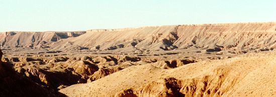
|
Old sidestream alluvium (early Pleistocene)--Three distinctive gravel types occur in different parts of the map area. The first type, south of the Virgin River, contains a variety of sedimentary and metamorphic lithologies from the Virgin Mountains, but black Proterozoic schist and gneiss are most common. South of the Virgin River the map unit is pale-brown, pale-yellowish-brown, light-brownish-gray, and pale-red, poorly to moderately consolidated, poorly sorted, poorly bedded gravel, sandy gravel, gravely sand and boulders. Calcrete soil is a distinctive ledge-forming unit that has been mapped separately as the old Pleistocene calcrete (Qok). Soil consists of a stage III carbonate-enriched horizon 0.5-1.5 m thick; no B or A horizons observed. Similar to intermediate-age sidestream alluvium (Qis) but stands a few meters higher and has a more developed soil. Limited area of exposure near eastern edge of map area, where it rests on Tertiary mainstream alluvium (Trm). Depositional top probably not preserved. Equivalent to the intermediate alluvial fan deposits (Qa2) of Billingsley (1995, Billingsley and Bohannon, 1995) in the adjacent Elbow Canyon and Littlefield quadrangles. Maximum thickness about 20 m. The second and third types occur north of the Virgin River and are similar except that the coarse clasts on the west side are angular fragments of calcrete, primarily eroded from the thick soil (Tok) capping Flat Top Mesa, just west of map area, and slightly younger soils (Tik) on other high surfaces of Tertiary age, whereas coarse clasts on the east side include well-rounded siliceous pebbles and cobbles. Otherwise they both consists of moderate-orange-pink to grayish-orange-pink and yellowish-gray, poorly to moderately consolidated, poorly sorted, and poorly bedded sand from the Muddy Creek Formation (Tms, Tmc). The deposits are locally covered by sheets of eolian sand (Qe) and may include some eolian sand. Where preserved, soils on old sidestream alluvium north of the Virgin River consist of 0.5-1.5 m thick stage II-III carbonate-enriched horizons and no preserved B or A horizons. Upper surfaces of the deposits are rounded between 2 and 10 m from the edge of washes. The rest of the opper surfaces are relatively flat and well preserved compared to similar deposits of Tertiary age (Trs). The deposits are generally remnants of alluvium sheets deposited on pediments cut on weakly consolidated Muddy Creek Formation (units Tms, Tmc) (Photo) . Depositional tops north of the Virgin River from 530 to 675 m altitude and as high as 60 m above present stream level. Maximum thickness about 10 m |
||
Trm |
Tertiary mainstream alluvium of Virgin River (Pliocene)--Pale-red, pale-reddish-brown, and light-brown, poorly sorted, poorly to well bedded gravel and sandy gravel; slightly to very strongly cemented by calcium carbonate. Gravel clasts consist of angular to subrounded gneiss, granite, pegmatite, quartzite, limestone, and dolomite mixed with lesser amounts of well-rounded, light-brown quartzite (Late Proterozoic and Lower Cambrian Prospect Mountain(?) Quartzite) and black and grayish-green chert. Most clasts less than 0.3 m in diameter; maximum clast size 1 m. No soil observed. Forms cliffs along Virgin River east of the map area. Terraces at levels about 35 and 55 m above present Virgin River channel (Qom) were cut on this deposit during erosion of alluvial fill. In the eastern part of the map area these deposits are mostly north of the Virgin River but in the western part they are only south of the river and the exposures become smaller westward until they cease near the southwest corner of the map area. Unit dips southward 2 to 10 degrees. Equivalent to the gravel of Virgin River (Tmv) of Billingsley (1995, Billingsley and Bohannon, 1995) in the adjacent Elbow Canyon and Littlefield quadrangles. Billingsley interprets his unit to be part of the Muddy Creek Formation, whereas the map unit is interpreted here to be inset into the Muddy Creek Formation. Depositional top probably between 560 and 575 m and 85 m above present stream level. Base is not visible. Maximum exposed thickness 50 m |
||
Trs |
Tertiary sidestream alluvium (Pliocene)--Three distinctive gravel types occur in different parts of the map area. The first type, south of the Virgin River, contains a variety of sedimentary and metamorphic lithologies from the Virgin Mountains, but black Proterozoic schist and gneiss are most common. South of the Virgin River the map unit is pale-brown, pale-yellowish-brown, light-brownish-gray, and pale-red gravel, sandy gravel, gravely sand and boulders. Distal part of the deposits south of the river is clast supported, well consolidated, moderately sorted, and well bedded, with maximum clast size about 1 m. Proximal part is matrix supported, well consolidated, poorly sorted, and poorly bedded, with maximum clast size about 3 m. Generally, unit is eroded into long, low, rounded ridges that lie along radial lines projecting down from the apex of a fan-shaped alluvial surface. The ridges are separated by wide surfaces covered with intermediate-age side-stream alluvium (Qis) graded to terraces of intermediate age mainstream alluvium along the Virgin River (Qim). The original calcrete soil has been stripped away in the map area, but the tops of narrow ridges are commonly littered with a residue of platy fragments from the upper part of the eroded carbonate-enriched soil horizon. Quartzite, gneiss, and pegmatite clasts on surface are irregularly to continuously covered by brownish-black to black, dull to shiny desert varnish as much as 2 mm thick; limestone and dolomite clasts are etched to depths of 1.5-3 cm. Depositional top not preserved but exposures range between 530 and 610 m altitude and 10 m above present stream level. Base of unit not well exposed but locally it can be seen to rest on or include lenses of Tertiary mainstream alluvium (Trm). Exposed thickness 25 m. The second and third gravel types occur north of the Virgin River and are similar to each other except that the coarse clasts on the west side are angular fragments of calcrete, primarily eroded from the thick soil (Tok) capping Flat Top Mesa, just west of map area, and slightly younger soils (Tik) on other high surfaces of Tertiary age, whereas coarse clasts on the east side include well-rounded siliceous pebbles and cobbles from conglomerate beds in the upper Muddy Creek Formation (Tmc). Otherwise they both consists of moderate-orange-pink to grayish-orange-pink and yellowish-gray, poorly to moderately consolidated, poorly sorted, and poorly bedded sand from the Muddy Creek Formation (Tms, Tmc). The deposits may include some eolian sand. Where preserved, soils on old sidestream alluvium north of the Virgin River consist of .5 to 1.5 m-thick stage III-IV carbonate-enriched horizons and no preserved B or A horizons. Upper surfaces of the deposits are rounded between 15 and 30 m from the edge of washes. The rest of the upper surfaces are rolling and irregular rather than flat because of erosion of the alluvium and because locally they are composites of surfaces formed at different times and slightly different altitudes. The deposits are generally remnants of alluvium sheets deposited on pediments cut on weakly consolidated Muddy Creek Formation (units Tms, Tmc). Unit probably correlative to the regrade gravel of Moapa (Tr) mapped by Schmidt and others (1996) in the Glendale area, which in turn is probably correlative with the Overton pediment alluvium in Moapa Valley of Gardner (1972b) in the lower Moapa Valley, about 30 km to the west. Depositional tops north of the Virgin River between 560 and 630 m altitude and as high as 60 m above present stream level. Maximum thickness about 20 m |
||
Tf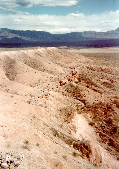
|
Post-Muddy Creek Tertiary basin-fill sediments (lower lower Pliocene)--Gray, poorly bedded, poorly sorted sandstone and conglomerate. Overlies the conglomeratic member of the Muddy Creek Formation in angular unconformity and is generally coarser and lighter colored than the Muddy Creek. Matrix-supported cobbles appear to be reworked from the conglomeratic Muddy Creek rather than being deposited by the Virgin River although the unit may grade into Virgin River gravels (Trm) southeastward. Probably deposited in a zone of tectonic subsidence at the foot of the Virgin Mountains. May be generally equivalent in age and depositional environment to the Marl of White Narrows (Twg) of Schmidt and others (1996) in the Glendale area, although the sediment in this map area is coarser and generally lacks carbonate. Depositional top is not exposed. Maximum exposed thickness 60 m. Photo |
||
Tmc |
Muddy Creek Formation, conglomerate facies (Pliocene? and upper Miocene)--Uncemented sandy cobble conglomerate probably deposited in wide shifting channels across the floor of a broad sandy basin. Lithologies of conglomerate clasts indicate that the conglomerate was deposited by an ancestral Virgin River that was integrated to distant headwaters in Utah. Pebble- to boulder-size clasts are primarily distinctive well rounded siliceous rocks from a southwest Utah provenance. Those rocks include brown quartzite (Late Proterozoic and Lower Cambrian Prospect Mountain(?) Quartzite) and black and grayish-green chert and lesser amounts of subangular to subrounded gneiss, granite, gray quartzite, basalt, pegmatite, limestone, and dolomite. The beds may be much younger than the underlying, fine-grained part of the Muddy Creek Formation but are included in the Muddy Creek here because they were probably deposited prior to regional incision, and are generally conformable to the underlying Muddy Creek beds in areas of deformation. The sudden appearance of conglomerates overlying hundreds of meters of Muddy Creek Formation deposits that lack clasts larger than pebbles marks a major rearrangement of regional drainage that brought the ancestral Virgin River to the west side of the Virgin Mountains. The unit probably correlates to the tan quartzite-granite clast gravel (Gardner, 1968, p. 55) that is 30 m thick immediately beneath the surface of the southern tip of Mormon Mesa about 15 km southwest of the map area. Maximum thickness about 40 m |
||
Tms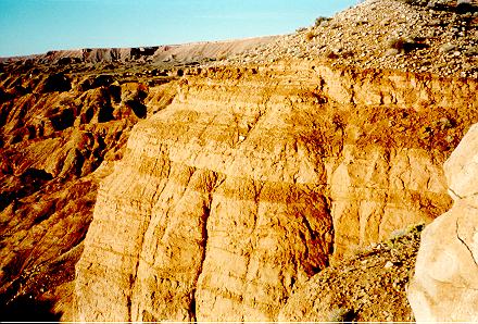
|
Muddy Creek Formation (Pliocene? and upper Miocene)--Upper 250 m of the map unit exposed in the map area is moderate-orange-pink, moderate-reddish-orange, light-red, and light-brown, fine- to medium-grained, partly consolidated, poorly to well bedded, gypsiferous sandstone, small amounts of siltstone and claystone, and minor conglomerate. Sandstone beds are moderately to well sorted, with common cross bedding and ripple marks. Individual beds generally die out within 50-200 m but bed sets may be continuous for 200-500 m or more. Clasts are locally cemented by calcite, clay, or gypsum. Selinite crystals locally abundant. Includes uncemented eolian sand beds that have remobilized during the Holocene to form dune fields where exposed to the wind. Some carbonate-cemented resistant sandstone beds appear to be buried calcrete soils. Exposed part of the map unit probably primarily deposited by small streams flowing across a broad sandy plain scattered with a few small lakes. Large lakes that probably covered the topographically lower parts of the Muddy Creek Formation depositional basin did not extend into the map area during the period when the upper part of the Muddy Creek Formation was being deposited. Intraformational angular unconformities indicate mild syndepositional tilting. Gouge zones along abundant normal faults that cut the Muddy Creek Formation are commonly 1 to 2 m thick and weakly cemented by gypsum and carbonate so that they are more resistant than the surrounding sand and thus etch out to low ridges. A few sandstone beds within the map area contain insect burrows and root casts, bird and animal tracks, and camel bones (Kowallis and Everett, 1986). Fossil remains of Megatylopus (camel), Hemiauchenia (llama), Aelurodon (dog), Indarctos (bear), Equinae (horse), and Texoceros (pronghorn) that were found in the formation on south side of Virgin River and immediately west of the map area indicate a medial Hemphillian (late Miocene) age (R.H. Tedford, American Museum of Natural History, unpub. data, 1978). Outcrops in the northwest part of the map area are continuous with Muddy Creek Formation of Longwell (1928, 1936) and Longwell and others (1965). Maximum exposed thickness about 250 m. Maximum thickness estimated from regional seismic, gravity, and magnetic data ranges from 600 m in the northwest corner to 1600 m in the southeast corner of the map area (Bohannon and others, 1993). Photo |
||
Tb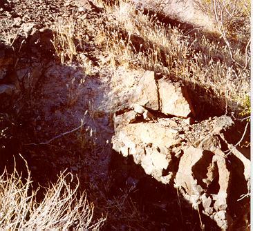
|
Tertiary basalt lava flow and ash (Pliocene? and upper Miocene)--Olivine basalt lava flow and coarse olivine basalt ash within the upper part of the fine-grained part of the Muddy Creek Formation. The basalt flow is exposed only on one small knob about 50 m in diameter 3 km northeast of the center of the map area (lat 36ー50'6"N., long 114ー2'2"W., UTM 764500 E, 4080500 N zone 11S). The base of the lava flow is not exposed, and no fragments of baked sandstone indicating intrusion were found in the surrounding colluvium. Weakly developed vertical columnar joints occur with a spacing of about 0.5 m. The rock is dark-grey to black, fine-grained, slightly vesicular basalt containing about 5 percent phenocrysts, mostly of olivine (Photo). The phenocrysts appear fresh but locally oxidized. Exposed rock faces weather to dark reddish brown. The rock is solid, but thin sections indicate the groundmass to be altered. This alteration may have affected the whole-rock potassium-argon analyses of the rock by Robert Fleck (U.S. Geological Survey, written commun., 1996), but two samples from opposite sides of the outcrop give essentially identical results. The age calculated for sample 9511137 is 4.1 ア 0.6 Ma and that for 9511149 is 4.1 ア 0.2 Ma. These calculations indicate a date of eruption that is younger than the age of 5 Ma estimated for the top of the Muddy Creek Formation elsewhere (Schmidt and others, 1996). The ash consists of black to reddish-brown aggregates of glass and porphyritic olivine basalt between 1 mm and 2 cm in diameter, locally cemented by a matrix of carbonate and alteration products. It forms a single discontinuous layer a few centimeters to 3 meters thick extending west and northwest of the lava exposure to beyond the boundaries of the map area. In many areas, the ash fills broad channels as much as 1 m deep beneath a gritty cemented sandstone bed. The ledge-forming sandstone bed has greater continuity and visiblility than the ash layer, and aids in tracing the ash, which has been mapped as a marker bed. Elsewhere the ash layer is as thick as 3 m and overlies several meters of eolian sand. Where eolian sand is present, the ash layer is offset by many small normal faults (photo) and is even intruded by the sand, probably indicating liquifaction. The ash is interpreted to relate to the flow because of their similar composition, stratigraphic position, and physical proximity, although the closest exposure of ash is 2 km from the flow. The closest other mafic volcanic rocks observed in the Muddy Creek Formation are 60 km to the southwest. Minimum thickness of lava flow 2 m. Maximum thickness of ash 3 m |
The oldest geologic materials exposed in the Mesquite quadrangle are poorly consolidated basin-fill sands and silts of the upper Miocene Muddy Creek Formation. The few well cemented beds are generally discontinuous but one distinctive bed can be traced across the northwestern two-thirds of the quadrangle. That bed of well-cemented granule sandstone records a basaltic volcanic eruption and commonly includes a single bed of black basaltic ash at its base. A small outcrop of basalt southeast of the exposures of ash is the only hard rock in the quadrangle and was probably erupted close to the vent that was the source of the ash. Alteration of the flow rock and the ash make precise radiometric dating of the eruption difficult, but analyses and calculation by Robert Fleck (U.S. Geological Survey, written commun., 1996) indicate that the eruption probably occurred about 4.1 ア .03 Ma. Several hundred meters stratigraphically above the ash layer, the sand beds are intercalated with uncemented conglomerates that include distinctive, well rounded siliceous cobbles from a southwest Utah provenance probably deposited by an ancestor of the Virgin River. The sudden appearance of these conglomerates marks a major rearrangement of regional drainage that brought the ancestral Virgin River to the west side of the Virgin Mountains. The Muddy Creek sands and conglomerates are unconformably overlain on the eastern side of the quadrangle by similar Tertiary sediments, probably of Pliocene age. All the Tertiary sediments were tilted, faulted, and locally folded to dip as steeply as 45 degrees, although most dips in in the Muddy Creek Formation are less than 10 degrees, and Pliocene sediments dip only a few degrees.
Inset into the Miocene and Pliocene sediments from east to west across the central part of the quadrangle are several generations of upper Pliocene and Quaternary sandy gravel alluvial deposits of the Virgin River. The relatively narrow extent of these deposits compared to the gravels of the upper Muddy Creek Formation implies that incision of the basin fill began before deposition of the inset alluvium began in the late Pliocene.
The southeastern third of the map area is covered by several generations of sheets of coarse, angular alluvial gravel and boulders from the nearby Virgin Mountains. A variety of lithologies are present but black Proterozoic schist and gneiss are most common. The oldest of these fan surfaces is the top of an aggradational gravel wedge that prograded across the finer basin-fill sediments prior to regional incision. The younger sheets are primarily thin pediment veneers cut on the Muddy Creek Formation and older gravels and then graded to various terraces of the Virgin River.
Several generations of thick, well-cemented calcrete soils are common in the map area. Buttes, mesas, and cuestas stand high above the landscape throughout the map area because they are capped by thick calcrete soils that are much more resistant to erosion than the Tertiary sands. The older calcrete soils are commonly tilted and offset by faults. Some are buried beneath younger sediments. Near the basalt flow, a Miocene calcrete soil developed on conglomerate beds of the Muddy Creek Formation was tilted 9 degrees and then buried beneath post-Muddy Creek Tertiary sediments. Calcrete soils that have not been buried generally dip less than 3 degrees. In some places resistant caps were formed by secondary layers of calcrete boulders and cobbles eroded from older soils and redeposited on lower surfaces.
The forces driving deformation of the Tertiary and Quaternary basin-fill deposits of the Mesquite quadrangle are primarily extension and subsidence. These forces reflect east-west extension of the Mesquite structural basin, perhaps along deep detachment faults connected to northwest-dipping normal faults exposed along the front of the Virgin Mountains about 4-10 km east of the map area (Anderson and Bohannon, 1993; Bohannon and others, 1993; Axen and others, 1990). The poorly consolidated deposits are extensively block faulted, although fault traces are obscure except where a calcrete or distinctive marker bed is offset. Most faults strike within 10 degrees of north-south.
Normal faults in the northeast part of the map area strike southsoutheast and are uniformly down to the west. They separate blocks tilted eastnortheast about 2 degrees. Farther to the west, the structure becomes more complex. Large east-dipping faults occur that are antithetic to the major faults, and beds dipping as steeply as 40 degrees form narrow anticlines and synclines. The folds do not seem to indicate compression but instead result from collapse of the soft sediments into underlying voids produced by extension. A block near the middle of the map area, mostly east of Town Wash, dips east in the northern part and west in the southern. The two parts are separated by an indistinct eastnortheast trending flexure. Minor faults in the northern part of that block generally dip west and in the southern part dip east.
The beds immediately adjacent to faults commonly roll sharply toward the fault. These dips are the result of drag on the upthrown block and collapse ("reverse drag") on the downthrown block. In some places, however, beds on the downthrown block dip away from the fault.
A single basaltic ash marker bed that appears to have been deposited on a low-relief basin-floor surface provides a measure of the deformation since its eruption. It occurs at a maximum altitude of about 775 m near the northwest corner of the map area and at a minimum altitude of about 515 m in the abutment of the dam in Town Wash, near the center of the map area. Near the center of the northern map boundary, the altitude of the ash is about 650 m. Average tilting of the Mesquite area since deposition of the ash is about 2.2 degrees to the southeast, or directly toward the Virgin Mountain front and oblique to the trend of normal faults and block tilting described above. This measure of tilting represents a generalization because the ash does not lie on a single plane over the area but is offset by many faults and tilted and folded within the blocks.
Rocks exposed both in the mountains surrounding the map area and penetrated by deep drill holes near the map area (Bohannon, 1991; Bohannon and others; 1993, Moore, 1972) indicate that until about the beginning of the Miocene (24 Ma) the Mesquite area was structurally similar to the Colorado Plateau of northern Arizona to the east. This changed during the Miocene with the onset of extensional stress, subsidence, and normal faulting that caused development of the basins and ranges of Nevada and relative uplift of the margins of the Colorado Plateau. Bohannon and others (1993) interpreted the complex events of the Miocene based on many lines of geological and geophysical evidence. Slow subsidence, without significant deformation, and accumulation of basin-filling Horse Springs Formation and older sediments occurred from 24-13 Ma. After this, from 13-10 Ma, normal faulting became important, resulting in deformation of basement rocks and basin fill and dividing the Mesquite basin from the basin to the west. The pre-13 Ma rocks subsided and were offset down to the west along the normal faults. As ranges rose and basins between them subsided, streams that formerly flowed toward the sea were blocked and their loads of sediment began to accumulate in the basins. Where water flow exceeded evaporation and subsurface drainage, large lakes formed over the sediments in the lowest part of the basins. Most of the sediments that filled the basins were sand and gravel eroded from the nearby ranges, but silt, clay, and fine sand also accumulated on the lake bottoms. Where the water was charged with carbonate from springs, lacustrine limestone beds were deposited, and where gypsum and salts eroded from Permian evaporite deposits were concentrated, complex secondary evaporite sequences were deposited. Gypsum was ubiquitous through the lake sediments and was reworked by wind and stream erosion and spread widely through much of the basin-fill sediments.
Intense faulting began after the early filling of the basins, and the basin-fill sediment was caught up in the tectonic movement and deformed. Highly deformed lower Miocene sedimentary rocks of the Horse Springs Formation and older basin-fill sediments (Bohannon, 1984) are about 600-1600 m beneath the land surface and 1500 m thick beneath the map area (Bohannon and others, 1993). In the later Miocene, basins having internal drainage became connected as sediment rose above the level of the divides between basins. Toward the end of the Miocene, the connected basins of the Muddy Creek lacustrine and fluvial system extended from the map area to beyond the present site of Las Vegas, 150 km to the southwest. The Muddy Creek lake may have extended into the map area during the late Miocene but by the end of the Miocene the shoreline was probably west of the map area somewhere between Riverside and Glendale, because the upper Muddy Creek Formation sediments exposed in the map area have fluvial rather than lacustrine characteristics.
After the end of deposition of the Horse Creek Formation, tectonic activity over most of the Muddy Creek lake area decreased drastically. Muddy Creek Formation over most of its extent in southern Nevada is generally flat lying, and, although it is offset locally by small faults, it is much less deformed than the Horse Springs Formation. The part of the Muddy Creek Formation that extended into the Mesquite tectonic basin surrounding the map area, however, is generally deformed. The area around Mesquite in particular continued to subside and be faulted throughout the deposition of the Muddy Creek Formation, as indicated by steep dips and angular unconformities within the formation, and deformation probably continues at present, as indicated by Quaternary fault scarps along the Virgin Mountain front just 4 km east of the map area (Billingsley and Bohannon, 1995).
A notable characteristic of most of the Muddy Creek Formation is a general lack of coarse clastic sediment. Except for the conglomerates in the uppermost part, it is rare to find clasts larger than fine pebbles, even close to bedrock hills. The possible implication is that the rate of accumulation of fine basin sediment was high relative to the rate of coarse sediment production from adjacent hill slopes. It also implies that no major streams were carrying gravel across the basin, and hence that the Virgin River was absent.
Distinctive Virgin River gravels appear suddenly in the uppermost part of the Muddy Creek Formation, probably due to capture of the Virgin River headwaters across the Virgin Mountains near the site of the present Virgin River gorge. Their northeasternmost occurrence is in the northeast corner of the map area, 13 km below the mouth of the gorge, and they can be traced southeast 33 km to the tip of Mormon Mesa. The gravels fill wide, shallow, shifting channels. Over most of their extent, the gravels are the uppermost deposits and they are flat lying, but in the map area and the tectonically active area at the tip of Mormon Mesa, they are tilted and buried by younger sediments. Capture of the Virgin River into the basin generally coincided with, and may have contributed to, the end of widespread accumulation of sediment in the extensive Muddy Creek lake basin. A more significant event that also may have occurred at about the same time was the capture of the Colorado River into the southern part of the Muddy Creek lake basin across the reach that now forms the Grand Canyon (Lucchitta, 1972, 1979).
At about the same time that the Colorado River began flowing into the Muddy Creek lake, probably about 5.5 Ma, the lake was breached and external drainage to the sea established. A resulting lowered base level caused deep incision of the soft basin fill to propagate headward along the Virgin River across the map area and radically changed the balance of erosion and deposition. Alluvial deposits record at least four cycles of incision and aggradation by the river and also record regrading of the surfaces between the river and the Virgin Mountains as their relative altitudes changed. During the earliest cycle, caused by breaching of the basin, the Virgin River incised more than 200 m to an altitude equal or lower than that of the present stream bed, and then aggraded more than 100 m (Williams, 1994). Subsequent cycles of lesser magnitude probably resulted from climate fluctuations. Gravelly terrace surfaces about 60 m above the present stream bed are estimated to be of early Pleistocene age based on development of calcic soil horizons. An extensive middle Pleistocene gravel terrace occurs at about 30 m above the present streams, and a sandy late Pleistocene terrace at about 6 m.
The gravel deposited by the Virgin River after its incision is generally coarser, less rounded, and has a greater percentage of local rocks than pre-incision gravels found in the upper Muddy Creek conglomerates. Fan and pediment gravel derived from the Virgin Mountains is preferred to Virgin River gravel as an aggragate source.
SCALE 1:24 000
CONTROL ELEVATIONS SHOWN TO THE NEAREST 0.1 METER
OTHER ELEVATIONS SHOWN TO THE NEAREST METER
CONTOUR INTERVAL 10 m
NATIONAL GEODETIC VERTICAL DATUM OF 1929
Base credit:
Base from U.S. Geological Survey, 1985, provisional edition
Projection: Transverse Mercator
10,000-foot State grid ticks based on Nevada coordinate system, east zone
1,000-meter Universal Transverse Mercator grid, zone 11. 1927 North American datum
Geology mapped in 1995-1996
Address questions, comments, and suggestions to:
Van S. Williams ------------------------(303) 236-1289
U.S.G.S. MS 913
DFC Box 25046
Denver, CO 80225-0046
E-mail comments to the author: Van S. Williams (vwilliam@usgs.gov)
Last update February 27, 1997
| AccessibilityFOIAPrivacyPolicies and Notices | |
| |
|
