By Carol J. Becker, Donna Runkle, and Alan Rea
U.S. Geological Survey Open-File Report 96-450
Prepared in cooperation with the
State of Oklahoma, Office of the Secretary of Environment
Oklahoma City, Oklahoma
1997
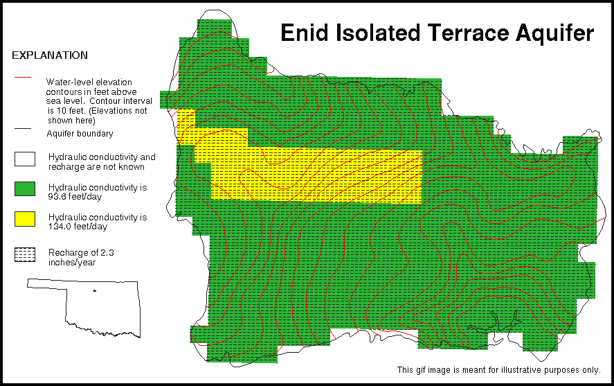
The data sets in this report include digitized aquifer boundaries and maps of hydraulic conductivity, recharge, and ground-water level elevation contours for the Enid isolated terrace aquifer in northwestern Oklahoma. The Enid isolated terrace aquifer covers approximately 82 square miles and supplies water for irrigation, domestic, municipal, and industrial use for the City of Enid and western Garfield County (Beausoleil, 1981). The Quaternary-age Enid isolated terrace aquifer is composed of terrace deposits that consist of discontinuous layers of clay, sandy clay, sand, and gravel. The aquifer is unconfined and is bounded by the underlying Permian-age Hennessey Group on the east and the Cedar Hills Sandstone Formation of the Permian-age El Reno Group on the west. The Cedar Hills Sandstone Formation fills a channel beneath the thickest section of the Enid isolated terrace aquifer in the midwestern part of the aquifer (Beausoleil, 1981).
These data are from the ground-water modeling thesis, "A ground-water management model for the Enid isolated terrace aquifer in Garfield County, Oklahoma," by Beausoleil (1981). The aquifer boundaries were digitized from plate 4 and the hydraulic conductivity and recharge data are from figure 14 and page 26 respectively, and were digitized from plate 4. The water-level elevation contours were digitized from plate 1. Plates 1 and 4 are photocopied paper maps that were published at a scale of 1:62,500. The data in the thesis also are presented in a ground-water modeling report of the Enid isolated terrace aquifer by Kent, Beausoleil, and Witz (1982).
Ground-water flow models are numerical representations that simplify and aggregate natural systems. Models are not unique; different combinations of aquifer characteristics may produce similar results. The hydraulic conductivity and recharge are closely interrelated. As long as these two model inputs are in balance the model has a small mean residual; it represents the natural system numerically. If the hydraulic conductivity is accurately known, the model can be used to accurately determine recharge. Likewise, if the hydraulic conductivity is poorly known, then the recharge will be poorly determined. Therefore, values of hydraulic conductivity and recharge used in the model and presented in this data set are not precise, but are within a reasonable range when compared to independently collected data.
In most aquifers, hydraulic conductivity measurements made in wells or in cores will range over several orders of magnitude, even over short horizontal and vertical distances. Hydraulic conductivity values derived from ground-water flow models represent areal generalizations and do not reflect the large local variance in well or core measurements. Recharge probably varies considerably over the local area, and model rechage is at best an average over an area at least as large as the model grid (and probably much larger than a single cell).
Compilation of the data sets was funded under a cooperative Joint Funding Agreement between the U.S. Geological Survey and the State of Oklahoma, Office of the Secretary of Environment.
These data sets were created for a project to develop data sets to support ground-water vulnerability analysis. The objective was to create and document digital geospatial data sets from published reports or maps, or existing digital geospatial data sets that could be used in ground-water vulnerability analysis.
The data sets provided in this report are available in nonproprietary and ARC/INFO export file formats. (See NOTES section.) Files, except those with ".GIF" or ".GZ" extensions, are ASCII format files.
The data sets stored in the generic, public-domain Digital Line Graph (DLG-3) Version 3, Optional format have file extensions of ".DLG". Designed for data interchange, the DLG-3 format allows the simple creation of a vector polygon or line data structure. The topological linkages are explicitly encoded for node, area, and line elements. The files are composed of 8-bit ASCII characters organized into fixed logical records of 80 bytes. A detailed description of the DLG-3 Optional format may be found in the data users guide 3, Digital Line Graphs from 1:2,000,000-scale maps (U.S. Geological Survey, 1990).
The ARC/INFO export files are ASCII files that utilize a proprietary format. The "NONE" compression option was used with the ARC/INFO EXPORT command. The ARC/INFO export files have file extensions of ".E00".
The data set files have ".GZ" extensions and were compressed for distribution. These files need to be uncompressed to access the digital data. The GUNZIP utility is an MS-DOS executable program that will uncompress the data files. To uncompress a file, type at the MS-DOS prompt:
GUNZIP -aN AQBOUND.GZ
This command will uncompress the file and restore its original name. For example: "AQBOUND.DLG" or "AQBOUND.E00"
A documentation file (known as metadata) is provided for each data set. The documentation files comply with the Federal Geographic Data Committee (FGDC) Content Standards for Digital Geospatial Metadata (Federal Geographic Data Committee, 1994). The FGDC-compliant metadata files contain detailed descriptions of the data sets, and include narrative sections that describe the procedures used to produce the data sets in digital form.
A graphic image also is provided in a Graphics Interchange Format (GIF) file. GIF files are easily displayed on a variety of computer systems that use readily available display software including Internet browser software. This image provides a simplified view of the data sets, and may be used for browsing purposes. The GIF file portrays significantly less spatial resolution and information content than the actual data sets.
No software is provided with these data sets. Users will need GIS software to use the data sets. The U.S. Geological Survey does not recommend or endorse any particular software package for use with these data sets. For some links to more information on GIS software and capabilities, see: The GIS FAQ (Frequently Asked Questions), GIS Companies on the WWW, USGS GIS Information.
The Albers Equal Area map projection (Snyder, 1987) was chosen for the data sets. This projection is appropriate for maps of the conterminous United States because of the visual presentation and equal-area characteristics, which facilitates areal analysis. The projection is cast on the North American Datum of 1983. This projection slightly distorts shapes and distances (scale) in order to maintain equal-area properties. Scale is true along the standard parallels, which are to the north and south of Oklahoma. Scale distortion in Oklahoma reaches a maximum of slightly less than one percent at the northern border of the state. The following table provides map projection information.
| Projection parameters: | |
|---|---|
| Spheroid | GRS1980 |
| Datum | NAD83 |
| First standard parallel | 29 30 00 North |
| Second standard parallel | 45 30 00 North |
| Central meridian | 96 00 00 West |
| Latitude of projection origin | 23 00 00 North |
| Coordinate system parameters: | |
| False easting | 0 |
| False northing | 0 |
| Planimetric units of measure | meters |
Use of trade names is for descriptive purposes only, and does not imply endorsement by the U.S. Government.
ARC/INFO software was used in the development of the data sets. The data sets were processed using the ARC/INFO Revision 7.0.3 software package, running on a Data General AViiON workstation. Further processing was done using ARC/INFO Revisions 7.0.4 and 7.1.1 on a SUN Enterpise 4000 running Solaris Version 2.5.1. File names in this document are enclosed in quotation marks and type set in upper case.
Beausoleil, Y.J., 1981, A ground-water management model for the Enid isolated terrace aquifer in Garfield County, Oklahoma: Stillwater, OK, Oklahoma State University, master's thesis, 66 p., 4 pls., 25 figs.
Federal Geographic Data Committee, 1994, Content standards for digital geospatial metadata (June 8): Federal Geographic Data Committee, Washington, D.C., 78 p.
Kent, D.C., Beausoleil, Y.J. and Witz, F.E., 1982, Evaluation of aquifer performance and water supply capabilities of the Enid isolated terrace aquifer in Garfield County, Oklahoma: Stillwater, OK, Department of Geology, Oklahoma State University report, 58 p., 19 figs.(Final report to the Oklahoma Water Resource Board)
Snyder, J.P., 1987, Map projections--A working manual: U.S. Geological Survey Professional Paper 1395, 383 p.
U.S. Geological Survey, 1990, Digital line graphs from 1:2,000,000-scale maps, data users guide 3: U.S. Geological Survey National Mapping Program Technical Instruction, 70 p.
| USGS-Oklahoma |

![]() U.S. Department of the Interior |
U.S. Geological Survey
U.S. Department of the Interior |
U.S. Geological Survey
URL: http://pubsdata.usgs.gov/pubs/of/1996/ofr96-450/index.html
Page Contact Information: GS Pubs Web Contact
Page Last Modified: Wednesday, 07-Dec-2016 16:01:54 EST