The Virginia Division of Minerals Resources (DMR) initiated a program to convert its published geologic maps and all future geologic mapping, compilation and map publishing activities to a digital basis. This decision was driven by several factors:
Need to reduce printing and storage costs
Need to reduce budget
Dramatic reduction in staff with restriction on future hiring
Increasing demand for digital information by clients and customers
In light of the budget and staff restrictions, a computer group of digitizing specialists with expensive single-task hardware and software was not realistic. Furthermore, experience had shown that the more distant the data entry activity was from the data collection activity, the more errors occurred and went uncorrected. Therefore, a basic requirement for software was that it should be capable of operating in the field on a 486 or Pentium portable computer and that it should be mastered easily by any field geologist. Other important requirements were the capabilities to:
draw mapped contacts directly over raster images of topographic sheets or satellite data
plot strike and dip data and other structural information
plot tabular data such as chemical analyses
embed digitally and retrieve field observations such as outcrop or thin-section photos
attach multiple attributes to lines and areas
create and maintain up-to-date digital geologic maps that can also be printed as "maps-on-demand"
produce digital maps in non-proprietary, simple, and ASCII file formats that can be readily translated into any other GIS format
The last requirement was important because as a state agency DMR felt that it could not show "favoritism" by requiring its clients and customers to purchase a particular brand of software in order to use the data. Furthermore, DMR is primarily concerned with map-making and providing data rather than with GIS analysis.
We examined a number of digital mapping systems a few years ago. The public domain GIV (Geologic Information Visualization) software developed by Russell Ambroziak of the USGS was simple but limited in scope. We collaborated with Innovative Technology of America (ITA) to develop ABICAS mapping software (which grew out of GIV) to meet all of the requirements of geologic mapping and printing at a state geological survey. ABICAS runs only on MS-DOS systems at the present time.
Four staff members have been involved with the technical process of software development and use over the past 2 to 3 years. No staff member has devoted a full-time effort to the digital program because of other critical on-going duties (field studies, computer network/hardware management).
We have not completed new geologic maps via the digital process in the field because field mapping is still in progress. Time requirements and costs for completion of new mapping by ABICAS are expected to be less than previously needed by conventional non-digital methods. This claim can be defended because we have over 2 years of experience in the conversion of published (paper) maps to digital.
The time required to digitize existing geologic maps varies with complexity and scale of the original map. The experience level of digitizing personnel is an additional but small variable in the total required time to complete a map. Using ABICAS, DMR has approximately 60 1:24,000-scale maps, 7 1:100,000-scale maps, and the 1:500,000-scale state geologic map in various stages of completion. Maps in the Appalachian Plateau (coalfields) require the most amount of time to complete because of the number of lines, line length (contacts near-parallel to topographic contours) and multiple attributes. For example, it required 50 person-days to complete the Virginia portion of the Pikeville 1:100,000 map, and 15 days for the Pound 1:24,000 quadrangle. Maps in the Valley and Ridge and Piedmont provinces required less than half of these times. The 1993 geologic map of Virginia is approaching completion and will likely require a total of 100 days.
The production of digital replicates of printed geologic maps involves two activities, data entry and editing. Data entry involves "heads-up" tracing lines over scanned images, creation of polygons, attributing lines and areas, and entry of point data (strike and dip, well locations, etc.). The bulk of this work has been done by undergraduate geology majors. The total time spent on instruction of an individual is less than a day, with slightly more time needed for those who have never used a computer. The subsequent activity of editing is done by senior staff of DMR. All digital maps undergo the same attitude of detailed scrutiny as used in final editing of printed maps. However, the digital process requires less time and is more complete in error detection and repair than the time and effort needed by the process used for printed maps.
For an average cost of $2,500/unit, DMR can give each staff geologist the mapping software, a zip drive and a laptop computer with CD-ROM. The geologists are able to digitize contacts in the field using geophysical data, scanned topographic maps, satellite images, and scans of older and possibly unpublished fieldmaps of the area. Upon returning to the office, they can print an up-to-date geologic map of the area with the base map of their choice within an hour. Typically (at the present time), our geologists collect data in the traditional manner on paper maps and notebooks and transfer the field data to digital either in a vehicle or the office. The compilation map is the digital map. Other than a scanner, the same equipment is used to convert published (paper) maps to digital. Complexity of file structure increases only with the data complexity demanded by the geologic map.
Our geologists benefit from DMR's decision to convert to digital mapping because they do not have to spend hours transferring linework or adding stick-on symbols and letters. Our customers benefit because they now have access to the latest geologic information should it be needed. They have the added benefit of getting maps with the boundaries, projections and scale they choose. DMR benefits because the error prone steps of transferring data and adding stickups are eliminated and digital geologic maps are easily updated and printed on-demand as required. Another benefit is that geologic field mapping is not restricted by existing and frequently outdated topographic maps. The geologists can use satellite imagery to update, supplement and perhaps replace the topographic base maps.
In house, we have recreated color geologic maps on paper (from digital "vector" files) that replicate the original published (paper) map in all respects. Geology, in color, appears over a subdued topographic/culture base. We have used a HP650 color printer at USGS prior to purchase of our own (HP Design Jet 2500 CP). Digital files created in ABICAS have been translated to ATLAS, dxf, and MAPINFO formats.
Several problems critical to the success of DMR's digital mapping program have recently been solved. The 3M Corporation using DMR data as tests created water-resistant paper for maps that will not "bleed" in water. 3M also will have available by fall UV fade-resistant pigment inks. Lastly, AML programs (conversion programs) are being created to facilitate the import of ABICAS files directly into Arc/Info.
Problems still remain. Two of the most important are exchanging data with the USGS and exchanging data with other adjoining states. In exchanging data, the issue is format. If the USGS requires all digital geologic mapping data to be submitted to them using the SDTS format only, many states on limited budgets will not be able to comply. Additionally, the SDTS compliant files are large making them unwieldy to transfer electronically. These files are awkward to use as intermediate files since the actual working formats are usually significantly smaller. A large empty harddisk is required to either translate the working files into SDTS or translate them out of SDTS.
All of our digital mapping begins with a raster image created by scanning a printed topographic or geologic map, including pencil or inked mylars. Maps are typically scanned in color at 150 dpi in a 24-bit Targa format. Some applications (scanned 1:100,000 topographic mylars) require higher resolution (200 to 300 dpi), but the increased file size is still acceptable. The program TGA2DAT reduces the Targa image to an 8-bit color image in ABICAS format (binary); it also creates a color palette file (figure 1), and an image header file, both in ASCII. The color palette file contains an individual intensity (from 0 to 255) of red, green and blue for the 256 possible colors. File size is considerably reduced with minimal loss of the color information common to printed geologic or topographic maps.
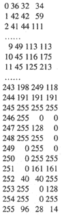
Figure 1. Portions of a typical image palette file where dots indicate removed data. The first column is the color number. The second, third and fourth columns are intensities of red, green and blue, respectively. An image pixel or line of number 246 would appear red on the computer screen.
The image is then georeferenced with the ABICAS program MAPROJ by entering control points on the image map graticules while viewing on the computer screen. Original map projection and these control points are used to define an algorithm that converts locations in screen coordinates to latitude and longitude. Average (rms) map error and error for each control point is provided. Any errors exceeding desirable limits for the digital map are therefore known; these errors may be reduced for the final algorithm by re-entry of one or more control points. It is not difficult to obtain any error of less than 20 feet (or 2 pixels) for 1:24,000-scale maps scanned at 150 ppi.
Entry of lines is done in a menu-driven environment with the program MAPTRACE. Tracing or entry of geologic contacts is done with a mouse over the map image on the computer screen ("heads-up" digitizing). Each click of the mouse enters a point, and a line immediately appears on the screen and joins the previously entered point. The ability to zoom in on the image to 4-power magnification, or greater, enables the operator to consistently trace and replicate lines within 1 pixel of the original image lines. Hence, some quality assurance is achieved during data entry. Editing of lines and points is possible during and after data entry. As image lines are traced, nodes are created by ending the entry of points and beginning a new digital line by snapping (a menu command) the beginning point of the new line to the last point on the previously entered line. Adjacent polygons that are eventually created in this manner, thus share the same line (line tracing is done only once). All ASCII data files created in ABICAS are converted to an equivalent binary file to increase the rate of processing; conversion to and from binary and ASCII formats is automatically or manually invoked.
We begin to attribute lines simultaneously with line entry. Sixteen of the 256 available image colors in the color palette file are reserved for lines (color numbers 240 through 255). One must accept a default or choose a line color number at the beginning of each line entered. The physical color of each color number can be changed with any ASCII file editor in the image color pallette file, by changing the intensity value for red, green, and blue. We standardized the use of the last 16 color numbers to the kinds of lines found on a geologic map: for example, line color 246 is used for approximate contacts (dashed lines on the printed map); 247, political boundaries; 248, exposed faults; 249, shorelines; 252, exposed coal bed or other thin concordant lithosome. Additional information about the line such as the kind of fault, its formal name (if any) or name of a coal bed can be entered later by defining an additional two attributes (figure 2). One defines, enters, edits, and queries line attributes in the program MAPLINE. Creation of subfiles based on attributes is also a commonly used option in MAPLINE.
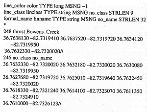
Figure 2. A typical line file in ABICAS. The first three lines are definitions for three line attributes (line color, line class and a formal name). The first line is a segment of the Bowens Creek thrust fault. Color number 248 is reserved for a line representing an exposed fault (solid, thick line in print). The first line contains four points. It is snapped to the second line as the lat/long coor-dinates (in decimal degrees) of the last point are precisely equal to the coordinates of the first point of the second line. The second line is an approximate contact (thin dashed line in print) signaled by color number 246. The end of a line is delimited by "//".
Not all lines on a geologic map make areas (polygons) that will become attributed (labeled) with a formation symbol (Qal, fill, Mb, etc.). Coal beds, dikes, faults often end without joining another line. Although these lines have been digitized, they will remain in a file for printing or query on computer at a later time. Such lines will not be used to create polygons, and will be removed by use of a series of "clean-up" programs. The program LIN2ARE creates an area file from the "cleaned-up" lines and contains linked polygons to their constituent lines (figure 3). Once an area file is created, one defines, enters, edits, and queries polygon attributes in the program MAPAREA.
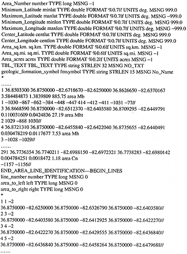
Figure 3. Portions of a typical area file in ABICAS where dots represent removed data. The first 11 lines are the definitions of required attributes, the 12th line "geologic_formation_symbol" is the first optional attribute we assign. Area 1 encloses the "Mb" formation and is made up of line number 1, 1030, 867, etc. The second part of the area file contains the constituent lines: line number 1 has area 1 to its left and area -2 to its right, followed by the points that define line 1.
The completely attributed digital map consisting of "vector" lines and table data is easily converted to a final colored raster image (of any scale and projection) with the program BAD2LBM and an ASCII raster control file that defines colors and patterns of areas. MAPLOT and an ASCII printer control file are used to plot dashed, dotted and solid lines in chosen thickness and color and structural or other symbols upon the colored raster image. A horizontal scale and graticules may also be plotted. The program MAPMIX is used to digitally overlay the geologic map on one or more base images. It is possible to combine a geologic map, topographic map, and a satellite image. The program COLLAR creates a map explanation and plots text or other images on the final raster image. This final raster image in 8-bit color may then be converted to 24-bit Targa (or TIFF, PCX) format that is compatible with many color printers or digital image editors.