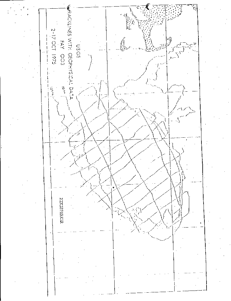
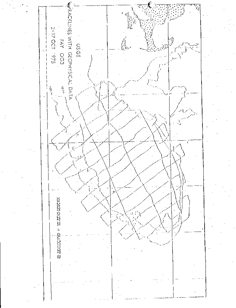
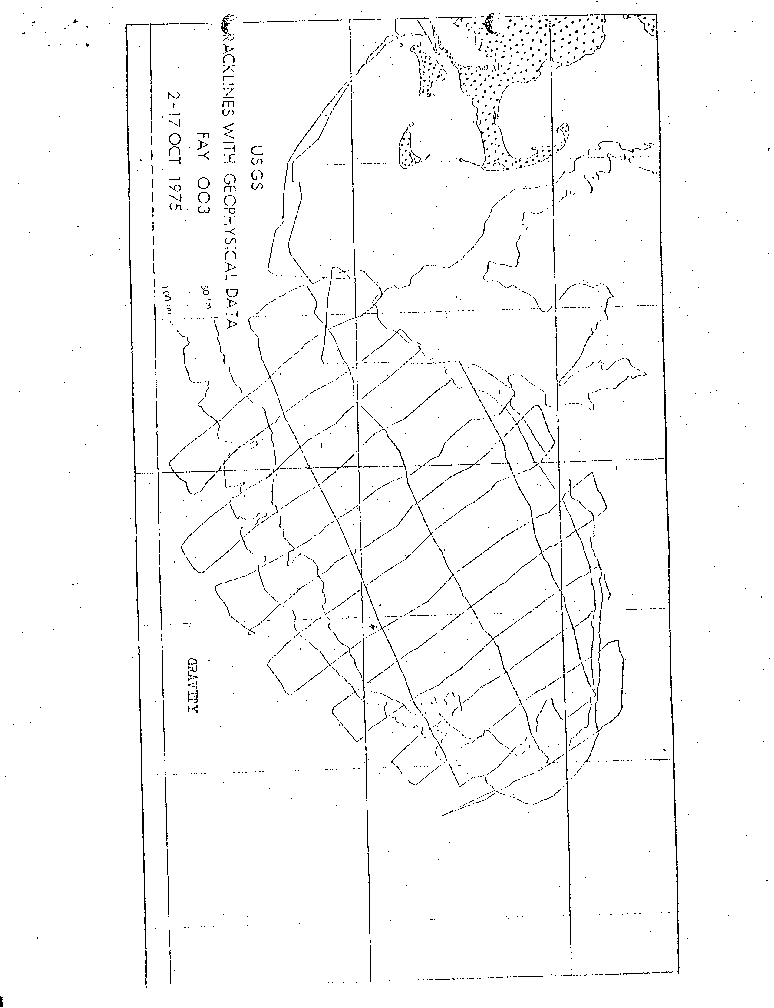
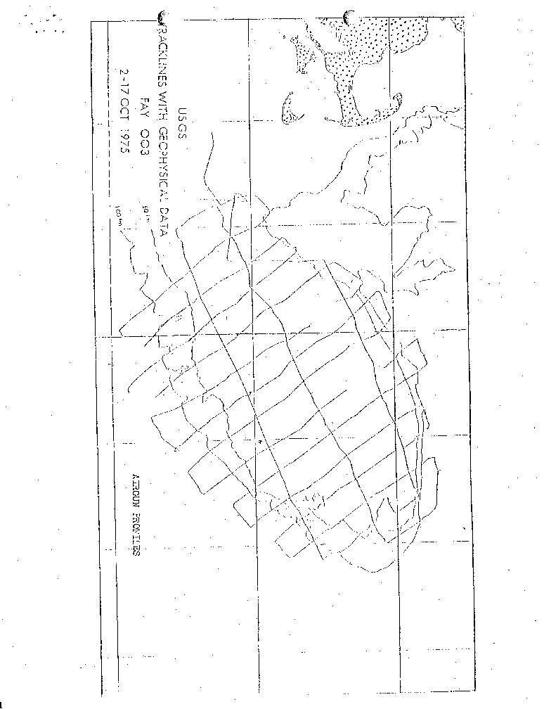
Latitude: 39.75dN - 42.5dN
Longitude: 71.5dW - 65.5dW
Paul Cousins, USGS
Ellen Davie, USGS
Dennis Edwards, USGS
Peter Gleba, USGS
Prescott Heald, USGS
Frank Jennings, USGS
Mike Kerkmann, USGS
Stanley Locker, USGS
Felicity Oram, USGS
Perry Parks, USGS
Douglas Peeler, USGS
Fran Scarver, USGS
Dick Sylwester, USGS
Lyle McGinnis, University of N. Illinois
Jim Biller, Third Mate
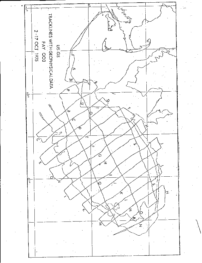
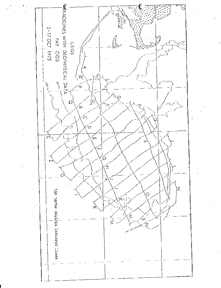
The cruise completed a survey with a 20 km line spacing (N-S) over the Bank with 3 tie 1,ines along the central northern and southern part of the Bank. Lines were extended into the deep ocean (1800 m) to assure coverage over the continental slope.
- October 2, 1975 (275 J.D)
Depart Woods Hole at 1225 (GMT or z) and motored down Vineyard Sound to Gayhead; seas calm, skies cloudy, wind from northwest 20-25 knots, course 236dT, speed 9.9 knots By 1445(z) Captain had decided to hold for the weather (passage of Hurricane Gladys); gentle swells, 1-2m. Deployed 3.5 kHz fish at 1514(z). The remainder of the day we motored in a triangular course southwest of the Elizabeth Islands, and in Vineyard Sound.
- October 3, 1975 (276)
At 0710z we left Vineyard Sound for Georges Bank. At 1230(z) we began to deploy gear for beginning of Line A. 1445(z) came to course 90xT to begin Line A; speed 61 knots Minisparker not functioning for much of Line A. Completed Line A at 2345; began Line B.
- October 4, 1975 (277)
Skies clear, sea spotted with whitecaps and a brisk wind. FAY had difficulty supplying adequate amount of salt water for cooling gravity van (temperature rose 5xC above normal value in hut), and flushing toilets. Ran Line B and part of Line C; began Line C at 1410(z). Three airgun fish out of operation from 1434 to 2030; operated on 160 cu. in. gun alone. SEI streamer out of action for the slope part of Line C; switched to a new streamer.
- October 5, 1975 (278)
Seas were calm, and skies clear and sunny. We completed Lines C, D and part of E. Perry Parks rigged up a new thermostat arrangement for the air conditioners in the gravity hut, and used the alternate unit to do most of the air conditioning. Both airgun units were pulled between 2002 and 2336 for servicing. Even with this attention, 40 cu. in. air gun continued to bleed between firings (5 sec.).
- October 6, 1975 (279),
Seas were calm, weather cool and skies cloudy. We completed Line E and part of Line F. We experienced power surges in ship's electric current which altered the time on the main clock used to mark the records. This clock was out several hours until a voltage stabilizer was put in between the digital clock and the electrical outlet, to protect against the surges. Corrosion in the connector at the winch for the SEI streamer, caused it to be down from 1656-1910(z); we used 100 Element Minisparker streamer over this time. Three airgun "fish" out for repair, 1321- 1514.
- October 7, 1975 (280)
Seas were choppy with a mild swell early in the day, deteriorating to 8-10 ft. waves and 40 knot winds. Weather was cloudy and became sunny and clear as the day progressed. We completed Line F and started Line G. All systems operational except 20 cu. in and 40 cu. in. air guns.
- October 8, 1975 (281)
Seas calm and weather partly cloudy to clear and sunny. We complete Lines G and H and part of I. Three airgun fish out of water for repair 1224-1830; 160 cu, in. gun down from 0133 to 1224; air lines were replaced on two compressors.
- October 9, 1975 (282)
Weather was clear and sunny. Seas were rough at night, moderating toward morning. We completed Line I and started Line J. Minisparker out because of erratically firing source and hydrophone malfunction from 0900-1240(z), 1309-1330, 1555-1918; a new amplifier-filter combination was set up. Loran C values were slewed because of a momentary power failure; both receivers stabilized in a manner similar to the digital clock. 160 cubic inch gun out from 0750-1524; three gun fish array out from 1210-1557.
- October 10, 1975 (283)
Seas were calm and the weather partly cloudy. We completed Line J and part of Line K. Three air gun array retrieved at 0435 (20 and 40 cubic inch guns not firing). Fish bent at a welded point of repair. 80 cubic inch fish deployed separately at 1505. Fish (with 40" and 20" guns) abandoned.
- October 11, 1975 (284)
Seas were calm. Weather sunny to partly cloudy. Lines K, L, were completed and Line M started. We experienced much ship traffic at the end of Line K, northern flank of Georges Bank. All systems Operational except 40 and 20 cu. in. airguns.
- October 12, 1975 (285)
Seas were calm in the early morning but as the day lengthened, seas became rough (10-12 ft. waves); weather changed from cloudy to rain with fog. We completed Line M and N; pulled gear after completion of Line N (1505z) and motored slowly southeast of line into heavy seas. Only gravity was measured during this time of waiting for seas to moderate and fog to lift. Seas moderated in the evening (2000-2100z) and we motored northeast toward the beginning of Line O. We had one close call while pulling gear, the "Cape Morrow", out of Halifax, passed within 50 yds of the FAY's port side. She was approached undetected on the FAY's radar because of "hash" on the radar screens caused by the agitated sea state. 160 cu. in. air gun out from 0222 to end of Line N (1505z).
- October 13, 1975 (286)
Cloudy weather, strong northwest wind (45 knots) came up in middle part of the day; 6-8 ft. waves. Sea state moderated toward latter part of the day. We commenced Line O at 0215z. Gravity and magnetometer data were noisy because of the choppy seas. All systems go except 20, 40, and 160 cu. in. airguns.
- October 14, 1975 (287)
Seas were smooth with a gentle swell. Weather was warm, sunny and clear. We completed Line O, P and part of Q. 160 cu. in, airgun substituted for 80" gun at 0250; by 0610 (z) a 40" gun was also in the water.. Upper Loran C unit malfunctioned and was repaired.
- October 15, 1975 (288)
Seas were extremely calm and weather clear in the early morning. We spent the 1200-1600 (z) watch manuvering on Line R in the fog to avoid fishing vessels. Lines Q and R were completed, and Line S was begun. All systems go except 20 and 80" air guns.
- October 16, 1975 (289)
Seas were calm in the early morning, becoming slightly rough as the day proceeded. Skies were sunny with a high cloudiness and haze. We completed Lines S, T, U, V and W. Because of a malfunctioning of Channel 7 on the tape recorder, we switched the minisparker input from this channel over to Channel 3. All systems operated normally except the 20" and 80" airguns. We completed survey at 2330 (z) and haul in all gear.
- October 17, 1975 (289)
Seas were calm. Pulled 3.5 kHz fish so FAY's clutch-drive train could be tested. Redeployed fish at 0054, but pulled it at 0106 because the 10 knot speed was too fast to tow it. Arrived in Woods Hole at 1110z.