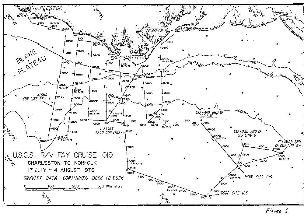
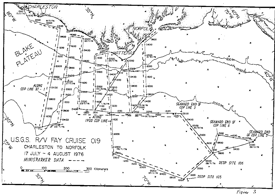
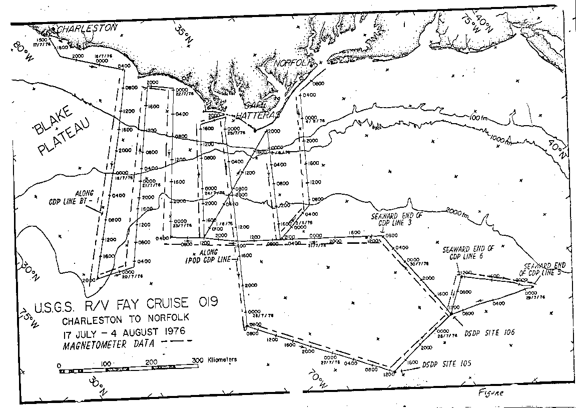
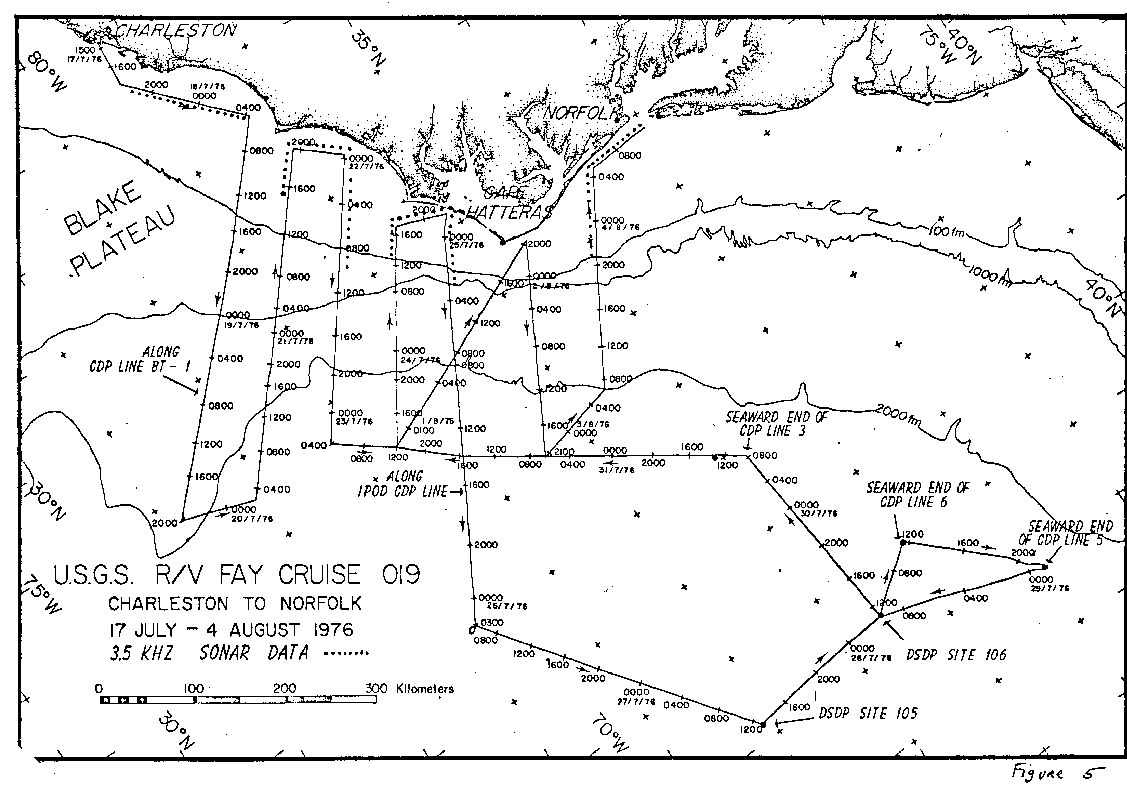
This cruise was conducted between Charleston and Norfolk and concentrated on long geophysical profiles over the continental shelf, slope, and rise off of Cape Hatteras. Eight long profiles were collected transverse to the margin and two were collected parallel to the margin along the rise which tied into deep sea drilling sites #105 and 106 (see Figure 1). Two of the transverse lines went along previously purchased multi-channel seismic data with the limited objective of collecting magnetic, gravity, and minisparker data to supplement the multichannel common depth point (CDP) reflection data.
Cape Hatteras falls between the prospective oil and gas lease areas of Baltimore Canyon Trough and the South Georgia Embayment where more detailed surveys have already been completed. Therefore, the lines around Cape Hatteras represent a minimal grid for airgun, gravity, magnetic, and minisparker profiles which fills in the gap between the two lease areas.
Latitude: 31.0dN - 38.25dN
Longitude: 80.0dW - 68.75dW
Gravity Data - 4770 km Airgun - 3590 km
Minisparker - 4270 km Magnetometer - 3940 km 3.5 kHz profiles - 680 km
Perry Parks,USGS, Navigation/Gravity Engineer
Dick Sylwester,USGS, Seismic Engineer
Barbara Tausey,USGS, cruise data curator
Rob Pexton, USGS
Jerry McCarthy, USGS
Felicity Oram, USGS
Kathy Kent, USGS
Scott Heald, USGS
Dave Egelson, USGS
Clare Reimers, USGS
Ralph Lewis, USGS
Barbara Tausey, USGS
Debbie Doyle, USGS
Lois Tomlinson, USGS
Norrie Robbins, USGS
see the description of the Integrated Navigation System under the Instrumentation heading of the Cruise Narrative for more detailed information regarding navigation system and techniques employed
Tom McSherry, 3rd Mate
Larry Weeks, Chief Engineer
Jim Corcoran, 3rd Engineer
Leslie Bryan, 3rd Engineer
Phil Trapasso, 3rd Engineer
Paul Murray, Bosun
Cape Hatteras falls between the prospective oil and gas lease areas of Baltimore Canyon Trough and the South Georgia Embayment where more detailed surveys have already been completed. Therefore, the lines around Cape Hatteras represent a minimal grid for airgun, gravity, magnetic, and minisparker profiles which fills in the gap between the two lease areas.
Four airguns of variable chamber capacity were available (2 each PAR600B with 20 or 40 cubic inch chambers and 2 each PAR1900C with 80 or 160 cubic inch chambers). During FAY 019, one 40 cubic inch gun was usually used on the shelf, while the 80 or 160 cubic inch guns were used in deeper water.
Filter settings for deep water work were usually between 16-60 Hz with 3 to 4 seconds of penetration frequently being obtained. The recorders were on a 5 second sweep on most occasions with up to a 5 second delay in deep water. Firing rates varied from 5 to 15 seconds. On a few occasions, 2 second sweep and firing intervals were tried in shallow water.
The four compressors leased from Price Compressor, Inc. allowed continuous operation without any loss time due to compressor failures.
Generally speaking, the single channel reflection profiles for FAY 019 were outstanding with excellent resolution of basement and the deeper Mesozoic horizons throughout the Western Atlantic.
The noise level on the two sensors was generally between +2 to 3 gammas, which was quite a bit higher than expected. In spite of all efforts to tune and adjust the system, this noise level persisted. The symptoms were relayed back to Woods Hole and Kim Klitgord was going to try some additional improvements during FAY 020.
Magnetic tapes of airgun, minisparker, and 3.5 kHz systems were also recorded on 3600 ft analog tapes on a seven track Honeywell system.
![]() a. Satellite
Receiver
a. Satellite
Receiver
![]() b. Teledyne Range-Range
LORAN C unit
b. Teledyne Range-Range
LORAN C unit
![]() c. Rubidium Frequency
Standard
c. Rubidium Frequency
Standard
![]() d. Doppler Sonar
- not installed
d. Doppler Sonar
- not installed
![]() e. Mark 29 gyrocompass
e. Mark 29 gyrocompass
![]() f. Hewlett Packard
21 MX computer system
f. Hewlett Packard
21 MX computer system
![]() g. Two 9-track
digital tape transports
g. Two 9-track
digital tape transports
![]() h. Calcomp 30 inch
plotter
h. Calcomp 30 inch
plotter
![]() i. Keyboard and
1 line printers
i. Keyboard and
1 line printers
This system encountered intermittent problems during the FAY 019 cruise. These were of the following nature:
During 18 July the weather deteriorated and 4 to 6 foot seas developed with intermittent thunder showers and lightning storms causing problems on the LORAN C and magnetometer systems. Intermittent lightning storms became a normal condition throughout the Cape Hatteras region during this cruise, especially at night.
From 2010Z/19 July 76 to 0223Z/20 July 76 the FAY ran a course of 016x up to beginning the next line toward shore which was on a course of 308x. Good airgun records with 3 to 4 sec of penetration were achieved on this line. This line was completed at 1923Z/21 July 76. The next cross-shelf line began at 2338Z/21 July 76 and continued until 0400Z/23 July 76. The next line toward shore began at 1203Z/23 July 76 and ended at 1705Z/24 July 76. The airgun system was retrieved 2210Z/24 July 76 in preparation for a high speed run down the IPOD CDP line where only gravity, magnetometer, sparker, and bathymetry data were needed. The IPOD line out as far as shot point #4000 was completed at 0300Z/26 July 76.
From there, a line from IPOD up to DSDP Sites #105 and 106 and then to the seaward end of CDP line #6 was completed during 0530Z/26 July 76 and 1123Z/28 July 76 with excellent airgun and sparker profiles. At that point, the airguns were shut off for maintenance while the ship headed NE toward the seaward end of CDP line #5. Our objective was to run a line toward the southwest which would cross CDP line #6, 3, and IPOD. However, upon reaching the seaward end of CDP line #5 and starting the line, we encountered a 4 to 5 knot Gulf Stream current to the northeast which made it impossible to conduct the planned line.
Because of the Gulf Stream encountered at the seaward end of CDP line #5, it was decided to abandon that line and return to DSDP Site #106 and try a line from there to the seaward end of CDP line #3 and then down across IPOD in the vicinity of IPOD Shot Point #2500. This plan was commenced at 1027Z/29 July 76. Excellent seismic profiles were obtained on this line which crossed IPOD and tied to the FAY 019 lines south of IPOD. This line parallel to the rise bathymetric contours was completed at 2301Z/31 July 76.
Time to complete only one diagonal and two cross shelf lines remained in the schedule. The airguns, magnetometer, and sparker were pulled for a high speed run up to the IPOD line. At 0500Z/1 August 76, we slowed to redeploy the airgun and sparker system and commence a diagonal line toward shore just north of Cape Hatteras. The magnetometer was not re-deployed at that time because an examination of excessive noise levels (+/-2-3 gammas) was needed. At 2030Z/1 August 76, the FAY had passed just north of Cape Hatteras and then changed course toward deep water on a course of 116d.
Between 2030Z/1 August 76 and 2005Z/2 August 76, the FAY traveled SE until crossing its previous track between IPOD and the end of CDP line #3. At 2005Z/2 August the FAY changed course to 345 degrees on a dog leg before commencing its final profile towards shore. Between 0610Z/2 August and 0448Z/4 August 76, this long line was completed. The FAY then turned north (352 degrees) toward Norfolk. At 1111Z/4 August all seismic systems were aboard and the FAY headed in to Norfolk. The FAY tied up at the Moon Engineering Inc. docks of Norfolk at 1100 local (1500Z)/4 August 76.