Latitude: 36.0dN - 41.75dN
Longitude: 73.75dW - 66.5dW
Dave Egelson, USGS
Claire Reimers, USGS
Hans Schouten, WHOI
Lin Morse, USGS
Chris Schoen, USGS
Sandy Conley, USGS
Nick Lefteriou, USGS
Dave Twichell, URI
Don Moller, WHOI
Frank Jennings, USGS
Jerry McCarthy, USGS
Dave Kinney, USGS
Wes Lombard, USGS
Paul Bereznak
see the description of the Integrated Navigation System (INS) under the heading Instrumentation of the Cruise Narrative
see the Instrumentation heading under Cruise Narrative
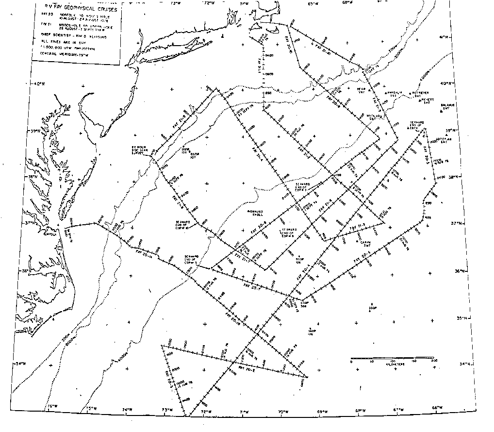
As part of a program to look at environmental problems on the continental shelf, slope and rise, a minisparker system was used to look at deFormation in the upper 1/2 sec. of sediment, including features such as slump structures. A one-day side scan survey was carried out at the mouth of the Wilmington Canyon to look at sand waves which form in that area.
Four airguns of variable chamber capacity were available (2 each PAR600B with 20 or 40 cubic inch chambers and 2 each PAR1900C with 80 or 160 cubic inch chambers). During FAY 20 & 21, one 40 cubic inch gun was usually used on the shelf, while the 80 or 160 cubic inch guns were used in deeper water.
Filter settings for deep water work were usually between 16-60Hz with 3 to 4 seconds of penetration frequently being obtained. The recorders were on a 5 second sweep on most occasions with up to a 5 second delay in deep water. Firing rates varied between 10 and 11 seconds.
The four compressors leased from Price Compressor, Inc. allowed continuous operation without any loss time due to compressor failures.
Generally speaking, the single channel reflection profiles for FAY 20 & 21 were outstanding with excellent resolution of basement and the deeper Mesozoic horizons througout the Western Atlantic.
Two types of airgun records were obtained during the cruise. The primary record was made on a Raytheon Recorder (called Ray #2) with AGC (automatic gain control), which allowed deeper horizons to be resolved. The normal 3.5 kHz recorder, also a Raytheon (called Ray #1) was used to produce a record without AGC and to act as a spare recorder. On FAY 21 the system was modified again to take the seismic information off of the read head on the tape recorder which was recording all'of the seismic information. This was played out on the secondary Raytheon recorder (Ray #1). In this manner we were able'to check what was going on to magnetic tape. At one point spurious noise was going onto the airgun trigger channel because of improper grounding of the minisparker system.
Minisparker - A new Teledyne 600 joule minisparker system was installed aboard the R/V FAY for FAY 019. Generally, this system was operated on the EPC Curley recorders on 1/2 second sweep with a 1 second repetition rate. These were generally filtered between 280-1060 Hz and beautiful records were obtained, even in water depths up to 5 km. Penetrations of 200-300 msec was common and in a few cases the sweep had to be lengthened to 1 sec because more than 500 msec of penetration was obtained. This system was an outstanding success which will provide valuable new high resolution control on the upper 500 meters of the sediment column.
3.5 kHz Echosounder - This system was in an O.R.E. fish and was towed off the port side at a depth of about 5 meters. A Raytheon CESP II pulse correlation system and automatic digital tracking system were employed. In general, this system failed to obtain any subbottom reflections (even on the continental shelf) and was of no value even as an echosounder in deep water. This system was turned off after about 6 hours of operation and its recorder used to obtain a second airgun record.
Geometrics Magnetic Gradiometer - The Geometrics Gradiometer tows two proton precession magnetometers on a single cable at 1000 and 1500 feet behind the ship. The total magnetic field of the aft bottle and their difference were recorded on a Hewlett Packard chart recorder and on digital magnetic tape (parts of the Integrated Navigation System).
The noise level on the two sensors was generally between -+2 to 3 gammas, which was quite a bit higher than expected. In spite of all efforts to tune and adjust the system, this noise level persisted. Attempts to improve the system were unsuccessful. The depressors were set at maximum depth but the lead weights were not used. The aft bottle was replaced for FAY 21 after a fire on deck, while in port, damaged the original aft bottle. Tests indicated that the problem was either in the towing of the bottles or in extra large permanent magnetization for the ship. Further tests are planned on future cruises and Geometrics have been informed of our problems.
Gravity - The R/V FAY was equipped with a gravity van containing a vibrating string gravity meter mounted on a Mark 19 Sperry gyrostabilized platform, on loan from Carl O. Bowin at Woods Hole Oceanographic Institution (on an Office of Naval Research grant). This system operated flawlessly during all of FAY 019.
Analog Seismic Recording System - During FAY 20 and 21, the minisparker was generally recorded on the EPC Curley 19-inch dry paper recorders. The 2 types of airgun records were two Raytheon 19-inch dry paper recorders. The signal with AGC was displayed on Raytheon #2 and the signal off the tape and without AGC was displayed on Raytheon #1.
Magnetic tapes of airgun, minisparker, and 3.5 kHz systems were also recorded on 3600 ft analog tapes on a seven track Honeywell system.
Integrated Navigation System (INS) - A new Integrated Navigation System was installed aboard the R/V FAY during February. This system was contracted through Western Geophysical Inc. and contains the following major sybsystems:
![]() a. Satellite
Receiver
a. Satellite
Receiver
![]() b. Teledyne Range-Range
LORAN C unit
b. Teledyne Range-Range
LORAN C unit
![]() c. Rubidium Frequency
Standard
c. Rubidium Frequency
Standard
![]() d. Doppler Sonar
- not installed
d. Doppler Sonar
- not installed
![]() e. Mark 29 gyrocompass
e. Mark 29 gyrocompass
![]() f. Hewlett Packard
21 MX computer system
f. Hewlett Packard
21 MX computer system
![]() g. Two 9-track
digital tape transports
g. Two 9-track
digital tape transports
![]() h. Calcomp 30 inch
plotter
h. Calcomp 30 inch
plotter
![]() i. Keyboard and
1 line printers
i. Keyboard and
1 line printers
This system encountered intermittent problems during the FAY 20 and 21 cruises, but in general the system worked fairly well. Whenever possible the INS was used to fire the airgun at a set distance interval but usually this was not very satisfactory and the computer was used to fire the guns at a 10 or 11 second repition rate.
Departing from the Wilmington Canyon, we headed back into deep water for one final traverse parallel to the continental margin. I,Je were contacted by U.S.G.S. Woods Hole at this point to see if we could conduct a side-scan survey on the edge of Georges Bank where the drill ship GLOMAR CONCEPTION had lost the on-floor drill assembly. Although the water depth was too deep for the amount of cable which we had on the side scan, we did go to the site and attempted to use the side scan. We could only get about 50 km from the bottom and did not see anything. We did find that it was very difficult to conduct a slow speed survey in that area because of the fast currents. We steamed back to Woods Hole, with the minisparker deployed and arrived in Woods Hole at about noon on September 7, 1976.