Large Mesozoic Structures
The Paleozoic formations are in allochthons (fault nappes) and are structurally
thinned severalfold from an original total stratigraphic thickness of about
1-2 km (Stone and others, 1983). The strata, allochthons, isoclinal folds,
and axial-planar foliation all dip northwestward on average 55-60deg., or
40deg. if Miocene tilting is restored. Vestiges of pre-Paleozoic foliation
in Proterozoic gneiss mostly now parallel this same orientation.
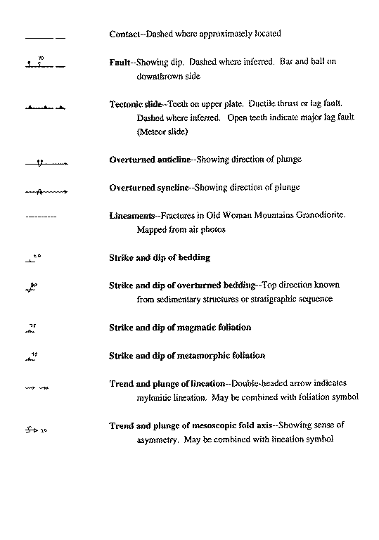
Tectonic slides in the metamorphic rocks define and separate the the Meteor
and Scanlon nappes and sliver and imbricate them internally. The nappe names
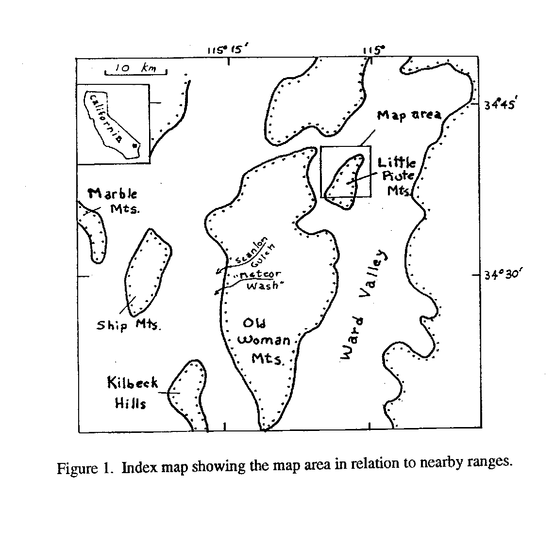
derive from exposures in Scanlon Gulch and the informally named Meteor wash,
both in the Old Woman Mountains (Fig. 1) (Howard and others, 1987; Rothstein
and others, 1994). Tectonic slides are ductile faults concordant to the
metamorphic foliation and identified mainly by stratigraphic juxtapositions
(Hutton, 1979). Thrust-fault slides duplicate section, and lag-fault slides
excise crustal section.
The post-slide Old Woman pluton, consisting of the Old Woman Mountains Granodiorite
of Late Cretaceous age, concordantly intrudes a roof of Proterozoic gneiss
that forms a thin rind between the pluton and the lower allochthon--the
Meteor nappe. The Meteor nappe (following the useage of Rothstein and others
[1994] in the Old Woman Mountains) is soled by a lag fault here referred
to as the Meteor slide. The Meteor slide was called the Little Piute fault
by Dennis and Karlstrom (1992), but this name had previously been applied
to a normal fault that projects under the map area from the west (Hileman
and others, 1990). We tentatively equate the Meteor slide to a fault called
the "Kilbeck thrust" by Jones (1973) and Evenson (1973) in the
Kilbeck Hills 40 km to the southwest. There as in the map area the Kilbeck
(Meteor) fault excises lower Paleozoic strata, and directly juxtaposes intricately
folded and slivered strata of upper Paleozoic to Triassic age onto the footwall
Proterozoic rocks. In the map area the Meteor slide soles the west-plunging
Titina isoclinal syncline in the hanging wall. Higher parts of the Meteor
nappe include intricate isoclines and slides.
The higher Scanlon nappe rides over the folded strata of the Meteor nappe
along a slide equated to the Scanlon thrust of Howard and others (1989a,b)
. The Scanlon nappe in the map area consists of an allochthonous plate >350
m thick of Proterozoic gneiss and a succeeding higher series of slides that
imbricate sections of inverted Cambrian and Proterozoic rocks. These latter
slides are here called Tashas thrusts for their canine codiscoverer. Outside
the map area the Scanlon thrust places inverted Cambrian rocks directly
on the Meteor nappe (Howard and others, 1989a; Nicholson, 1990). The fact
that Proterozoic gneiss is inverted along with the Paleozoic formations
in this nappe indicate that the nappe may be a basement-cored fold nappe
with its base sheared off.
The Scanlon and Meteor nappes, the underlying rind of footwall gneiss beneath,
and the younger and deeper Old Woman pluton together define a northwest-dipping
tectonic layering. This layering can be traced for 45 km along strike southwest
from the Little Piute Mountains across the Old Woman Mountains and Kilbeck
Hills (Miller and others, 1982; Howard and others, 1987, 1989a,b; Horringa,
1989; Rothstein, 1990; Rothstein and others 1994; Nickolson, 1990).
The Titina syncline in the Meteor nappe is the largest fold in the map area.
Triassic schist cores the syncline, and in turn encloses a coaxial synformal
anticline of successively older rocks in the core, as deep as the metamorphosed
Coconino Sandstone. Mapped strata close northeastward around this interior
anticline as they do for the enclosing syncline. Cenozoic deposits conceal
whether the anticline has a refolded shape like a fishhook, as we suggest
in cross section DD', or instead may be an eye fold. In either case its
exposed axial surface, and that of its enclosing syncline, parallel the
regional foliation.
A second mapped syncline, in the central upper part of the Meteor nappe
just below the Scanlon thrust, appears eye-shaped but highly attenuated
and partly disrupted by slides. The metamorphosed Bird Spring Formation
in this fold encloses a core of the metamorphosed Hermit and Coconino formations,
with the Hermit commonly cut out on the upper limb (section BB'). Truncation
of the southwest end of the syncline's core by its upper limb along a small
slide obscures the syncline's geometry relative to an underlying anticline.
Small mapped slides such as this one show complex patterns. An apparent
lag slide clips the top of the anticline which intervenes between the two
synclines, and traces northeastward where it is mapped to join and sole
a west-opening thrust imbricate. Thin slices of Proterozoic and upper Paleozoic
rocks interfinger along the Scanlon thrust zone. Above the Scanlon thrust,
Tashas thrusts splay to the southwest in a pattern of mostly west-facing
imbricate slices of inverted rocks that would be consistent with westward
overthrusting. Dennis and Karlstrom (1992) offered an alternate interpretation
from the map pattern of folds that thrusting was top-to the northeast.
Mesozoic Fabrics
Within 100 m of the Scanlon and Kilbeck slides, the Proterozoic rocks become
highly fissle, dark, lineated tectonic schist showing evidence of intense
strain in the plane of the regional foliation. Annealed petrographic textures
in the schist record static recrystallization after deformation. Shiny,
fine-grained micaceous foliation surfaces in this schist represent recrystallized
phyllonite cleavage. Despite its recrystallization the tectonic schist in
places preserves shear-sense indicators such as feldspar augen with tails
(Simpson and Schmid, 1983). Observed shear senses measured parallel to the
west-trending lineation at each slide (six localities adjacent to the Meteor
slide and six adjacent to the Scanlon thrust) are equally disposed top-to-the-east
and top-to-the west.
Lineation in the metamorphosed strata and the tectonic schist mostly plunges
moderately westward and is concordant across the various tectonic sheets.
This lineation encompasses mineral lineations, stretching lineations parallel
to shear (in the tectonic schist), stretched pebbles (in metaconglomerate
of the metamorphosed Wood Canyon Formation), and rod-like fold hinges (prominent
at the hinges of map-scale folds in quartzitic marble). Stretched pebbles
where measured quantitatively show ratios of maximum-to-minimum pebble diameter
of 2.6:1 to 5:1:1; strain-ellipsoid k values of about one suggest pure shear
in the direction of pebble elongation (Kelly, 1991). Locally pebbles are
highly prolate and we estimate the ratio of maximum-to-minimum diameter
as great as 12:1.
Quartz and green amphibole fill tension gashes perpendicular to lineation
in the Triassic schist. The gashes indicate stretching parallel to fold
axes and lineation. Boudin alinement perpendicular to the west-trending
lineation in Proterozoic gneiss of the Scanlon allochthon also suggests
stretching along the lineation.
Mapped folds plunge parallel to the lineation and to mesoscopic folds. Lineations
and fold axes steepen progressively toward the southwest and are nearly
straight down the dip of the axial-planar foliation in and near the mapped
exposures of Triassic schist in the Titina syncline. Lineations and folds
thus steepen toward this area while remaining coplanar within the regional
foliation. Planar foliation surfaces in the metamorphosed Coconino Sandstone
in this area exhibit lineation that is wavy and locally varies abruptly
as much as 50deg. in orientation in distances of a few centimeters. As a
further complication, nearly coaxial mesoscopic second folds, with steeply
north-dipping axial planes, fold the axial-plane foliation in the Triassic
schist in this same area; no map-scale equivalents were recognized.
Other structures misalined with the main foliation and lineation in the
range are rare. A north-trending intersection lineation, defined by pencil
schist in a single outcrop of tectonic schist below the Meteor slide in
the northeast part of the area, lies perpendicular to west-trending lineation
nearby and is consistent with folding perpendicular to the local east-west
shear direction defined by the lineation and shear indicators. Coplanar
folds of variable plunge are found in the northwesternmost mapped exposure
of the dolomite gray marker bed (DCdg).
The main foliation and lineation shared by the metamorphic rocks at all
levels intensifies near the Scanlon and Meteor slides. The deformation that
produced the fabric therefore apparently involved intense deformation along
both slides.
Cross Sections
Cross sections (AA', BB', CC', and DD') are designed to highlight the shape
of folds in the Meteor nappe. Construction of the cross sections was based
on two premises. The first is that mapped Mesozoic folds project into the
cross sections parallel to the (westward) plunge of mesoscopic folds and
lineations, at varying plunge angles. (Dennis and Karlstrom in 1992 had
instead suggested that the geometry of folds in relation to the imbricate
thrusts can be viewed in a single north-looking projection.) The second
premise for cross-section construction for this map is that the shape of
the imbricate horses can be viewed by looking northward down the foliation,
on the presumption that the lines of intersection between imbricate thrusts
project into the cross sections as lines that lie within the foliation plane
and perpendicular to the plunge of folds and lineation. This second premise
has no supporting field evidence, but is inferred on the assumption that
shear directions of thrusting and imbrication paralleled the lineations
as is suggested by shear indicators.
Pluton Emplacement and Cooling
The concordant Old Woman pluton locally dikes across the metamorphic foliation
in its roof. Final crystallization of the pluton at about 74 Ma and static
recrystallization of metamorphic rocks therefore outlasted the ductile deformation
of the metamorphic rocks. An apatite fission-track age of about 53 Ma for
the pluton dates cooling to near 100deg. C (Foster and others, 1991). This
date and other thermal history data from the adjacent Piute and Old Woman
Mountains provide evidence that the metamorphic and plutonic rocks cooled
and uplifted rapidly from mid-crustal depths after pluton intrusion (Foster
and others, 1990, 1991, 1992).
Tertiary Rocks and Structures
Early Miocene rocks rest nonconformably on the pre-Tertiary rocks. Knoll
(1985) detailed the early Miocene section and described a paleovalley fill
at the south margin of the map area and a shallower paleovalley fill near
the outcrops of Triassic schist to the north. Our mapping suggests the southern
paleovalley fill is on the order of 250 m thick below the Peach Springs
Tuff. This is less than Knoll's proposed 830-m thickness. These paleovalley
fills are defined by conglomerate, sandstone, tuff, and flows of basalt
and andesite. The 18.5-Ma Peach Springs Tuff, a regional ignimbrite, overlies
these paleovalley fills and locally rests directly on the pre-Tertiary rocks
at the edges of the paleovalleys. A sequence of sandstone, tuff, and conglomerate
succeeds the Peach Springs Tuff.
Tertiary normal faults in the map area strike northwest and northeast. Breccia
zones along the Tertiary faults demonstrate their brittle character, and
breccia zones also indicate that small brittle movements locally modified
parts of the Meteor slide and smaller slides. Travertine and silica fill
a northeast-striking fault in the southwest part of the map area
The Miocene stratigraphic units dip northwestward 5-20deg.. This dip is
considered to reflect middle Miocene rotation on the underlying Little Piute
normal fault, which dips southeast under the Little Piute Mountains from
exposures west of the map area (Howard and John, 1987; Hileman and others,
1990). Those authors considered the Little Piute fault and its hanging-wall
block to be near the western breakaway for Miocene detachment faults in
the Colorado River extensional corridor.
REFERENCES CITED
Bishop, C.,B., 1964, Needles sheet: California Division of Mines and Geology,
Geologic Map of California, Olaf P. Jenkins edition, scale 1:250,000.
Burchfiel, B.C. and Davis, G.A., 1977, Geology of the Sagamore Canyon-Slaughterhouse
Spring area, New York Mountains, California: Geological Society of America
Bulletin, v. 88, p. 1623-1640.
Cooksley, J.W., Jr., 1960a, Geology and mineral resources of Township 6
North, Ranges 17 and 18 East, San Bernardino base and meridian, San Bernardino
County, California: San Francisco, Southern Pacific Land Company, scale
1:24,000.
Cooksley, J.W., Jr., 1960b, Geology and mineral resources of Township 7
North, Ranges 17 and 18 East, San Bernardino base and meridian, San Bernardino
County, California: San Francisco, Southern Pacific Land Company, scale
1:24,000.
Cooksley, J.W., Jr., 1960c, Geology and mineral resources of Township 6
North, Ranges 19 and 20 East, San Bernardino base and meridian, San Bernardino
County, California: San Francisco, Southern Pacific Land Company, scale
1:24,000.
Cooksley, J.W., Jr., 1960d, Geology and mineral resources of Township 7
North, Ranges 19 and 20 East, San Bernardino base and meridian, San Bernardino
County, California: San Francisco, Southern Pacific Land Company, scale
1:24,000.
Dennis, M.L. and Karlstrom, K.E., 1992, Geometry and kinematic history of
mid-crustal Mesozoic deformation: Little Piute Mountains, southern Cordillera:
Geological Society of America Abstracts with Programs, v. 24, no. 5, p.
19.
Evenson, W.A., 1973, Geology of the southern Kilbeck Hills and an adjacent
portion of the Old Woman Mountains, eastern Mojave Desert, San Bernardino
County, California: Los Angeles, Calif., University of Southern California,
M.S. thesis, 51 p.
Foster, D.A., Harrison, T.M., and Miller, C.F., 1989, Geochronology of the
Old Woman-Piute batholith, California: Age, inheritance, and uplift history:
Journal of Geology, v. 97, p. 232-243.
Foster, D.A., Harrison, T.M, Miller, C.F., and Howard, K.A., 1990, 40Ar/39Ar
thermochronology of the eastern Mojave Desert, California, and adjacent
western Arizona with implications for the evolution of metamorphic core
complexes: Journal of Geophysical Research, v. 95, p. 20,005-20,024.
Foster, D.A., Miller, C.F., Harrison, T.M., and Hoisch, T.D., 1992, 40Ar/39Ar
thermochronology and thermobarometry of Mesozoic metamorphism and plutonism
in the Old Woman Mountains area, California: Geological Society of America
Bulletin, v. 104, p.176-191.
Foster, D.A., Miller, D.S., and Miller, C.F., 1991, Tertiary extension in
the Old Woman Mountains area, California: Evidence from apatite fission
track analysis: Tectonics, v. 10, p. 875-886.
Hileman, G.E., Miller, C.F., and Knoll, M.A., 1990, Mid-Tertiary structural
evolution of the Old Woman Mountains area: Implications for crustal extension
across southeastern California: Journal of Geophysical Research, v. 95,
p. 581-597.
Horringa, E.D., 1989, Rocks and structural evolution of the northern Kilbeck
Hills, San Bernardino County, California: San Jose, California, San Jose
State University, M.S. thesis, 180 p.
Howard, K.A. and John, B.E., 1987, Crustal extension along a rooted system
of imbricate low-angle faults: Colorado River extensional corridor, California
and Arizona, in Coward, M.P., Dewey, J.F., and Hancock, P.L., eds.,
Continental extension: Geological Society of London Special Publication
No. 28, p. 299-311.
Howard, K.A., John, B.E., and Miller, C.F., 1987, Metamorphic core complexes,
ductile thrusts, and Cenozoic detachments: Old Woman Mountains-Chemehuevi
Mountains transect, California and Arizona, in Davis G.H., and VandenDolder,
E.M., eds., Geologic diversity of Arizona and its margins: Excursions to
choice areas: Arizona Bureau of Geology and Mineral Technology, Geological
Survey Branch, Special Paper 5, p. 365-382.
Howard, K.A., Horringa, E.D., Miller, D.M., and Stone, Paul, 1989a, Geologic
map of the eastern parts of the Cadiz Lake and Cadiz Valley 15-minute quadrangles,
San Bernardino and Riverside Counties, California: U.S. Geological Survey
Miscellaneous field studies map MF-2086, scale 1:62,5000.
Howard, K.A., Stone, Paul, and Miller, C.F., 1989b, Geologic map of the
Milligan 15-minute quadrangle, San Bernardino County, California: U.S. Geological
Survey Miscellaneous field studies map MF-2072, scale 1:62,5000.
Howard, K.A., Stone, Paul, Pernokas, M.A., and Marvin, R.F., 1982, Geologic
and geochronologic reconnaissance of the Turtle Mountains area, California:
West border of the Whipple Mountains detachment terrane, in Frost,
E.G. and Martin, D.L., Mesozoic-Cenozoic tectonic evolution of the Colorado
River region, California, Arizona, and Nevada (Anderson-Hamilton volume):
San Diego, Cordilleran Publishers, p. 341-354.
Hutton, D.H.W., 1920, Tectonic slides: A review and reappraisal: Earth Science
Reviews, v. 15, p. 151-172.
Jones, J.A., 1973, Geology of the northern Kilbeck Hills and an adjacent
portion of the Old Woman Mountains, eastern Mojave Desert, San Bernardino
County, California: Los Angeles, Calif., University of Southern California,
M.S. thesis, 56 p.
Kelley, M.C., 1991, Geometric and kinematic structural analysis of Late
Cretaceous ductile thrust zones in the Old Woman Mountains region, southeastern
California: Flagstaff, Northern Arizona University M.S. thesis, 128 p.
Knoll, M.A., 1985, The early Miocene geologic history of the Old Woman Mountains
area, eastern Mojave Desert, California: Nashville, Tennessee, Vanderbilt
University, M.S. thesis, 186 p.
Miller, C.F., Howard, K.A., and Hoisch, T.D., 1982, Mesozoic thrusting,
metamorphism, and plutonism, Old Woman-Piute Range, southeastern California,
in Frost, E.G. and Martin, D.L., Mesozoic-Cenozoic tectonic evolution
of the Colorado River region, California, Arizona, and Nevada (Anderson-Hamilton
volume): San Diego, Cordilleran Publishers, p. 561-581.
Miller, C.F., Wooden, J.L., Bennet, V.C., Wright, J.E., Soloman, G.C., and
Hurst, R.W., 1990, Petrogenesis of the composite peraluminous-metaluminous
Old Woman-Piute Range batholith, southeastern California: Isotopic constraints,
in Anderson, J.L., ed., The nature and origin of Cordilleran magmatism:
Geological Society of America Memoir 174, p. 99-109.
Miller, E.L., 1981, Geology of the Victorville region, California: Geological
Society of America Bulletin, Part II, v. 92, p. 554-608.
Nickolson, H.T., 1990, Structural evolution of the Mesozoic Scanlon shear
zone, California: Flagstaff, Northern Arizona University, M.S. thesis, 80
p.
Nielson, J.E., Lux, D.R., Dalrymple, G.B., and Glazner, A.F., 1990, Age
of the Peach Springs Tuff, southeastern California and western Arizona:
Journal of Geophysical Research, v. 95, p. 571-580.
Prave, A.R., Fedo, C.M., and Cooper, J.D., 1991, Lower Cambrian depositional
and sequence stratigraphic framework of the Death Valley and eastern Mojave
Desert region, in Walawender, M.J. and Hanan, B.B., eds., Geological
excursions in southern California and Mexico, Guidebook 1991 Annual Meeting
Geological Society of America, San Diego, California, October 21-24, 1991:
San Diego, California, Department of Geological Sciences, San Diego State
University, p. 147-170.
Reynolds, R.E., 1992, Miocene vertebrates in the Little Piute Mountains,
southeastern Mojave Desert, in Reynolds, R.E., compiler, Old routes
to the Colorado: Redlands, California, San Bernardino County Museum Association
Special Publication 92-2, p. 92-94.
Rothstein, D.A., 1990, Regional metamorphism, ductile deformation, and granitoid
plutonism in the central Old Woman Mountains, southeastern California: Flagstaff,
Northern Arizona University, M.S. thesis, 126 p.
Rothstein, D.A., , Karlstrom, K.E., Hoisch, T.D., and Morrison, J., 1994,
Synkinematic contact metasomatism: implications for the timing of pluton
emplacement and regional deformation in the Scanlon shear zone, south-eastern
California: Journal of Metamorphic Geology, v. 12, p. 709-721.
Simpson, Carol and Schmid, S.M., 1983, Microstructural indicators of sense
of shear in shear-zones: Geological Society of America Bulletin, v. 94,
p. 1281-1288.
Stone, Paul, Howard, K.A., and Hamilton, Warren, 1983, Correlation of metamorphosed
Paleozoic strata of the southeastern Mojave Desert region, California and
Arizona: Geological Society of America Bulletin, v. 94, p. 1135-1147.
Walker, J.D., 1987, Permian to Middle Triassic rocks of the Mojave Desert,
in Dickinson, W.R. and Klute, M.A., eds., Mesozoic rocks of southern Arizona
and adjacent areas: Arizona Geological Society Digest, v. 18, p. 1-14.
Wooden, J. L and Miller, D.M., 1990, Chronologic and isotopic framework
for Early Proterozoic crustal evolution in the eastern Mojave Desert region,
SE California: Journal of Geophysical Research, v. 95, p. 20,133-20,146.
Young, R.A. and Brennan, W.J., 1974, Peach Springs Tuff: Its bearing on
structural evolution of the Colorado Plateau and development of Cenozoic
drainage in Mohave County, Arizona: Geological Society of America Bulletin,
v. 85, p. 83-90.
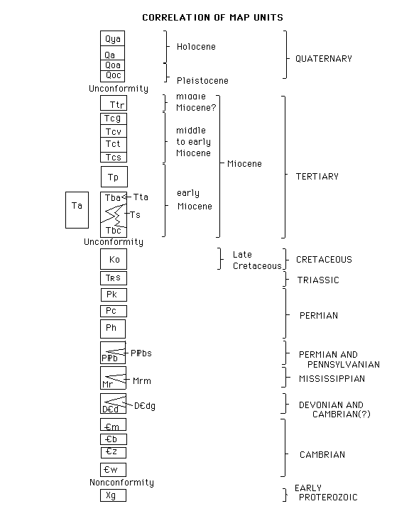
Alluvial-fan materials (Quaternary)--Poorly sorted sandy gravel and gravely sand. Clasts subangular to angular. Deposited by sheet floods, channelized floods, and debris flows. Subdivided into:
Qya Younger alluvium (Holocene)--Unconsolidated sand and gravel in active washes
Qa Intermediate-age alluvium (Holocene)--Forms undissected alluvial fans. Light-colored on aerial photographs
Qoa Older alluvium (Pleistocene)--Forms moderately dissected alluvial fans. Surface is dark desert pavement of varnished clasts where source materials are mafic or volcanic rocks, and surface is light colored where source materials are granodiorite or marble. Reddish soil
Qoc Calcareous older alluvium (Pleistocene)--Calcrete and calcrete-cemented arkose thicker than 1 m. Represents a partly eroded paleosol developed on alluvium
Ttr Travertine and chalcedony (middle Miocene?)--Fills a fault in Miocene rocks in southwest part of map area. Contains opaline veins. Interpreted as hot-spring deposits
Conglomerate, sandstone, and tuff (middle to early Miocene)--Divided into:
Tcg Granite-clast conglomerate--Arkosic conglomerate dominated by cobbles and pebbles of granite and granodiorite and rarer basalt
Tcv Volcanic-clast conglomerate--Dominated by cobbles and, locally, boulders derived from the Peach Springs Tuff and mafic volcanic rocks. Clasts include lesser amounts of quartzite, marble, gneiss, and muscovite granite
Tct Tuff, tuffaceous sandstone, and sandstone--Uppermost 10-15 m consist of white tuff and interbedded brown arkosic sandstone. Lower beds are pale yellow tuffaceous sandstone and light gray fine-grained sandstone. Vertebrate faunal assemblage described by Reynolds (1992)
Tcs Sandstone--Coarse to medium-grained gray to light red arkosic sandstone and conglomerate. Beds generally 0.5-1 m thick. Rare cross beds and symmetrical ripple marks suggest northward-directed currents. Locally contains boulders as wide as 0.5 m derived from Old Woman Mountains Granodiorite and more rarely from muscovite granite
Tp Peach Springs Tuff of Young and Brennan (1974) (early Miocene)--Welded rhyolite ash-flow tuff. Weathers pink, brown, or (where poorly welded) white. Contains abundant phenocrysts of sanidine, commonly showing blue adularescence, and small amounts of plagioclase, quartz, biotite, hornblende, sphene, and pyroxene. Forms resistant ridge-capping outcrops. Dated by K-Ar method on sanidine at 18.3 + 0.6 Ma (Howard and others, 1982, Table 3, map no. 14); accepted age of unit as dated by 40Ar/39Ar methods from near Kingman, Arizona, is 18.5 + 0.2 Ma (Nielson and others, 1990)
Ta Hornblende andesite (early Miocene)--Forms an isolated inselberg near the north edge of the map area; another present just north of the map area. Stratigraphic position relative to other Miocene units is inferred
Tba Basalt and andesite flows (early Miocene)--Dark gray. Two analysed samples of olivine-bearing basalt contained 52% and 50% SiO2 (Knoll, 1985: appendix 3, units LP6 and LPN)
Tta Tuff and arkosic conglomerate (early Miocene)--Contains angular pebbles of granite. Locally present; 2-3 m thick. Interbedded in the basalt and andesite flows
Ts Sandstone (early Miocene)--Sandstone, tuffaceous sandstone, and minor claystone and siltstone. Color ranges from red to white or (where tuffaceous) green. Red sandstone in section 36 exhibits mud cracks and tracks of several kinds of vertebrates (Reynolds, 1992). In sec. 11, T.6 N., R. 18 E. according to Knoll's (1985) descriptions, the unit consists (in ascending order) of white to gray, medium-grained sandstone of largely felsic volcanic grains, a medial boulder conglomerate consisting of clasts similar to those of the boulder conglomerate unit (Tbc), and a gray coarse arkosic sandstone derived in part from Old Woman Mountains Granodiorite
Tbc Boulder conglomerate (early Miocene)--Unsorted diamictite and poorly sorted, matrix-supported boulder and cobble conglomerate, both with red sandy matrix. Clasts are angular to rounded and are largely quartzite, as wide as 1.5 m, derived from the metamorphosed Zabriskie Quartzite and Wood Canyoin Formation. Quartzite boulders exhibit dark-red rinds as thick as 6 mm. Gneiss clasts are next most common and increase in abundance southward. Includes exotic boulders of granite porphyry not recognized in outcrop in the region. Clasts derived from Old Woman Mountains Granodiorite are rare. Forms basal conglomerate that lies nonconformably on pre-Tertiary rock units
Ko Old Woman Mountains Granodiorite (Late Cretaceous)--Light-gray-weathering, medium-grained sphene-hornblende-biotite granodiorite. Aplite dikes and pegmatite dikes at the margins contain muscovite. A porphyritic facies, which contains phenocrysts of alkali feldspar 0.5-1 cm in maximum dimension, has gradational boundaries and is present in the west 1/2 sec. 6, T. 6 N., R. 19 E. and east 1/2 sec. 1, T. 6 N., R. 18 E. Unit forms part of the Old Woman pluton (Miller and others, 1982). Top or northwest margin of pluton is concordant against gneiss and marble and intrudes gneissic country rock lit par lit. Age about 74 Ma by U-Pb and 40Ar/39Ar dating (Foster and others, 1989; Miller and others, 1990)
TRs Schist (Triassic)--Green to gray, brownish-gray-weathering, finely laminated epidote-quartz-biotite calc- schist and lesser quartz-biotite schist. Commonly folded and well lineated; in places shows two generations of folds. Locally includes a thin, basal calcareous quartzite. Schist protolith is inferred to be calcareous siltstone. Correlated in a general way with the Moenkopi Formation to the northeast and probably with the Fairview Valley Formation to the west, both of Early Triassic age (Stone and others, 1983; Walker, 1987)
Pk Metamorphosed Kaibab Limestone (Permian)--White, light-gray, bluish gray and dark-gray calcitic marble that contains siliceous, folded, dark-brown-weathering metachert lenses. Locally associated with pods of very coarse-grained secondary calcite. May include metamorphosed equivalents of the Toroweap Formation
Pc Metamorphosed Coconino Sandstone (Permian)--Very light gray- to pink-, red-, or tan-weathering, laminated, fine-grained vitreous quartzite. Well lineated commonly. Forms fine rubble or bold outcrops; locally consists of siliceous breccia that forms bold outcrops. Yellow carbonate layer is present in one fold hinge. Fine, even fracturing may reflect aeolian lamination
Ph Metamorphosed Hermit Shale (Permian)--Green to reddish brown calcareous and chloritic phyllite, and massive, dark-brown-weathering sandy metalimestone. Typically weathers as rounded knobs. Thin-bedded (5-10-cm thick) maroon and gray calcareous metasiltstone is present locally. Quartz and green amphibole fill tension gashes oriented perpendicular to lineation
PPb Metamorphosed Bird Spring Formation (Permian and Pennsylvanian)--Thick-bedded, ledgy, light gray calcitic marble, sandy marble, brown-weathering quartzitic marble, brown-weathering green calc-silicate rock, buff dolomitic marble, quartzite, and rare fine-grained quartz-mica schist. Brown-weathering siliceous grains scattered through marble reflect quartz sand grains in the protolith; cross-bedding is locally preserved. A bed of vitreous quartzite as thick as 1 m is present near the top of the unit. Lower part of formation gradational with underlying Redwall Limestone. Locally, includes:
PPbs Siliceous marker beds--Resistent beds of dark brown-weathering calcareous quartzite and calc-silicate rock, and a medial marble bed. This subunit is correlated with similar beds within a section of the Bird Spring Formation 40 km to the west in the Ship Mountains, where they directly underlie beds containing Early Permian (Wolfcampian) fusulinids. Subunit is interpreted as a westward-thinning sandy tongue of the Supai Group (Stone and others, 1983)
Mr Metamorphosed Redwall Limestone (Mississippian)--White, massive, coarse-grained calcitic marble. Locally contains gray marble beds, alternating thin layers of gray and white marble and rare calc-schist, and irregular patches of buff dolomite. Locally, includes:
Mrm Metachert--Marble containing resistant, closely-spaced siliceous lenses and nodules of dark-brown-weathering white metachert. Commonly silicified by secondary quartz
DCd Dolomite (Devonian and Cambrian?)--Massive to thick-bedded tan dolomite marble. Local vesicle-like pits where ovoid calcitic pods a few millimeters across have weathered out resemble features in the Valentine Member of the Sultan Formation (Devonian) mapped 70 km to the north in the New York Mountains by Burchfiel and Davis (1977). Rare tremolitic clots 10-30 cm across may be remnants of silicic stromatoporoids as in the Sultan Limestone in the Victorville area, 200 km west of the map area (Miller, 1981). Stratigraphic position below the Redwall Limestone further indicates that this unit includes the metamorphosed Sultan Limestone of Devonian age; unit may also include rocks of Cambrian age (Stone and others, 1983). Locally includes:
DCdg Gray marker bed--Dark gray dolomite marble 2-20 m thick. Shows small internal isoclines
Cm Marble (Cambrian)--Tan to gray calcitic marble. Considered to include metamorphosed rocks of the Chambless Limestone, Cadiz Formation, and lower part of the Bonanza King Formation
Cb Metamorphosed Bright Angel Shale (Cambrian)--Mica schist, phyllite, and minor gray and buff calcitic marble
Cz Metamorphosed Zabriskie Quartzite (Cambrian)--White to light gray or tan, fine- to medium-grained, massive, vitreous quartzite. Interpreted to represent a shallow-marine environment (Prave and others, 1991)
Cw Metamorphosed Wood Canyon Formation (Cambrian)--Gray to brown micaceous quartzite, cross-bedded quartzite, and metaconglomerate. As much as the lower 12 m of the section is quartz-pebble metaconglomerate (Prave and others, 1991). Considered to represent an alluvial braidplain by Prave and others (1991). Nonconformably overlies Proterozoic gneiss. Pebbles are stretched parallel to lineation; Kelly (1991) measured ratios of maximum-to-minimum diameter ranging from 2.6 to 5.1; ratio locally reaches 12
Xg Gneiss (Early Proterozoic)--Gneiss, granite gneiss, veined gneiss, pegmatitic gneiss, augen gneiss, muscovite granite gneiss, amphibolite, micaceous schist, garnet schist, staurolite schist, and feldspathic quartzite. Veined gneiss exhibits ptygmatic folds of dark-bordered leucocratic veins. Within10-100 m of the Scanlon thrust and Meteor slide, the rock is commonly a highly fissle but annealed tectonic schist, shiny where recrystallized mica defines relict phyllonitic cleavage surfaces