|
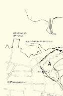
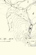
Figure 11.
Map showing area (svæði), dates indicating duration of lava-cooling operations (tímabil), and quantity (magn) in tonnes (metric tons) of seawater delivered.
Nýjasjúkrahúsið = new hospital;
Gígur = crater of Eldfell;
Gagnfæðaskóli = high school;
Básaskersbryggja and Nausthamarsbryggja = Básaskers Wharf and Nausthamars Wharf, respectively.
Vestmannabraut, Kirkjuvegur, and Sólhlíð are names of three streets in Vestmannaeyjar.
Click on image to zoom in.
|
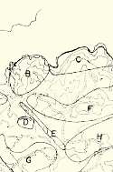
|
| SVÆDI |
TÍMABIL |
MAGN |
|
|
Mtonn. |
| A |
27/3-13/5 '73 |
0,90 |
| B |
10/3-22/3 '73 |
0,40 |
| C |
15/4-21/5 '73 |
0,50 |
| D |
25/3-26/3 '73 |
0,02 |
| E |
11/2-22/3 '73 |
0,10 |
| F |
19/5-10/7 '73 |
0,87 |
| G |
1/4-20/4 '73 |
0,51 |
| H |
21/4-3/7 '73 |
1,04 |
| I |
4/4-25/6 |
0,71 |
| J |
11/4-19/6 '73 |
1,12 |
|