
OPEN-FILE 97-745 C
SHEET 10 OF 11
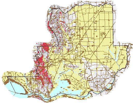
SUMMARY DISTRIBUTION OF SLIDES AND EARTH FLOWS
IN
SOLANO COUNTY, CALIFORNIA
By
Carl M. Wentworth, Scott E. Graham, Richard J. Pike, Gregg S.
Beukelman,
David W. Ramsey, and Andrew D. Barron
NOTE: Actual Map Size is 34x34
Inches and Includes Detailed Roads.
|
MAP UNITS
 Mostly Landslide - consists of
mapped landslides, intervening areas typically narrower than 1500
feet, and narrow borders around landslides; defined by drawing
envelopes around groups of mapped landslides. Mostly Landslide - consists of
mapped landslides, intervening areas typically narrower than 1500
feet, and narrow borders around landslides; defined by drawing
envelopes around groups of mapped landslides.
|  Many Landslides
- consists of mapped landslides and more extensive intervening areas
than in 'Mostly Landslide'; defined by excluding areas free of mapped
landslides; outer boundaries are quadrangle and County limits to the
areas in which this unit was defined. Many Landslides
- consists of mapped landslides and more extensive intervening areas
than in 'Mostly Landslide'; defined by excluding areas free of mapped
landslides; outer boundaries are quadrangle and County limits to the
areas in which this unit was defined.
|
 Few Landslides -
contains few, if any, large mapped landslides, but locally contains
scattered small landslides and questionably identified larger
landslides; defined in most of the region by excluding groups of
mapped landslides but defined directly in areas containing the 'Many
Landslides' unit by drawing envelopes around areas free of mapped
landslides. Few Landslides -
contains few, if any, large mapped landslides, but locally contains
scattered small landslides and questionably identified larger
landslides; defined in most of the region by excluding groups of
mapped landslides but defined directly in areas containing the 'Many
Landslides' unit by drawing envelopes around areas free of mapped
landslides.
|  Flat Land - areas
of gentle slope at low elevation that have little or no potential for
the formation of slumps, translational slides, or earth flows except
along stream banks and terrace margins; defined by the distribution
of surficial deposits (Wentworth, 1997). Flat Land - areas
of gentle slope at low elevation that have little or no potential for
the formation of slumps, translational slides, or earth flows except
along stream banks and terrace margins; defined by the distribution
of surficial deposits (Wentworth, 1997).
|
INTRODUCTION
Slides and earth flows are landslides
that can pose serious hazard to property in the hillside terrain of
the San Francisco Bay region. They tend to move slowly and thus
rarely threaten life directly. When they move - in response to such
changes as increased water content, earthquake shaking, addition of
load, or removal of downslope support - they deform and tilt the
ground surface. The result can be destruction of foundations, offset
of roads, and breaking of underground pipes within and along the
margins of the landslide, as well as overriding of property and
structures downslope.
DESCRIPTION
The best available predictor of where
movement of slides and earth flows might occur is the distribution of
past movements (Nilsen and Turner, 1975). These landslides can be
recognized from their distinctive topographic shapes, which can
persist in the landscape for thousands of years. Most of the
landslides recognizable in this fashion range in size from a few
acres to several square miles. Most show no evidence of recent
movement and are not currently active. Some small proportion of them
may become active in any one year, with movements concentrated within
all or part of the landslide masses or around their edges.
This map provides a summary of the
distribution of landslides evident in the landscape of the San
Francisco Bay region. Original identification and map delineation of
these landslides required detailed analysis of the topography by
skilled geologists, a task generally accomplished through the study
of aerial photographs. Such original landslide maps are now
available for most of the region at scales of 1:24,000 - 1:62,500
(Pike, 1997). The summary map presented here makes selected use of
these original maps and the 9-county compilation by Nilsen, Wright,
and others (1979) to provide a basis for initial evaluation of areas
vulnerable to slumps, translational slides, and earth flows in the
region.
The summary map modifies and improves
the compilation by Nilsen and Wright, which was prepared from sources
available in the mid-1970's. The generalized landslide distribution
shown on that map has here been improved in areas where the 1970's
sources were notably deficient, has been extended to include Santa
Cruz County, and includes the distribution of surficial deposits that
define landscape not generally vulnerable to these kinds of
landslides. The method of compilation and resolution of 1:125,000 (1
inch = 2 miles) limits use of the map to regional considerations. For
more detailed information, see the maps listed by Pike (1997) or
consult local officials or private consultants.
REFERENCES
Cooper-Clark and Associates, 1975, Preliminary map of landslide
deposits in Santa Cruz County, in Seismic Safety Element of the
County General Plan: Santa Cruz County, California, Planning
Department, 1 sheet, map scale 1:62,500.
Dwyer, M.J., Noguchi, N., and O'Rouke, J., 1976, Reconnaissance
photointerpretation map of landslides in 24 selected 7.5-minute
quadrangles in Lake, Napa, Solano, and Sonoma Counties, California:
U.S. Geological Survey Open-File Map 76-74, map scale 1:24,000.
Ellen, S.D., Cannon, S.H., and Reneau, S.L., 1988, Distribution of
debris flows in Marin County, plate 6, in, Ellen, S.D., and
Wieczorek, G.F., eds., Landslides, floods, and marine effects of the
storm of January 3-5, 1982, in the San Francisco Bay region,
California: U.S. Geological Survey Professional Paper 1434, map scale
1:62,500.
Huffman, M.E. and Armstrong, C.F., 1980, Geology for Planning in
Sonoma County: California Division of Mines and Geology, Special
Report 120, Landslides and Relative Slope Stability, map sheets 2A
and 2B, map scale 1:62,500.
Nilsen, T.H., and Turner, B.L., 1975, Influence of Rainfall and
ancient landslide deposits on recent landslides (1950-71) in urban
areas of Contra Costa County, California: U.S. Geological Survey
Bulletin 1388.
Nilsen, T.H., Wright, R.H., and others, 1979, Relative slope
stability and land-use planning in the San Francisco Bay region,
California: U.S. Geological Survey Prorfessional Paper 944, map scale
1:125,000.
Pike, R, J., 1997, Index to detailed maps of landslides in the San
Francisco Bay region, California: U.S. Geological Survey Open-File
Report 97-745 D.
Wentworth, C.M., 1997, General distribution of geologic materials in
the San Francisco Bay region, California: a digital map database:
U.S. Geological Survey Open-File Report 97-774, database resolution
1:125,000.
U.S. Department of the Interior
United States Geological Survey Base scanned
from U.S. Geological Survey Bay Region Topographic Sheets, scale
1:125,000, 1970 (Aitken, D.S., 1997, USGS OFR
97-500) Shaded relief base derived from
Graham, S.E., and Pike, R.J, 1997, USGS OFR 97-745
B Universal Tranverse Mercator projection,
Zone 10
This map is a plot derived from data
contained in the digital database Open-File Report 97-745, "San
Francisco Bay Region Landslide Folio" A PostScript image of this map
is included in the Open-File Report, but the Open-File Report does
not contain a paper copy of this map. The Open-File Report consists
of the digital data and a pamphlet explaining the database and
indicating how to obtain the data from which this map was prepared as
well as the PostScript image of the map.
This report is preliminary and has not
been reviewed for conformity with U.S. Geological Survey editorial
standards or with the North American Stratigraphic Code. Any use of
trade, product, or firm names is for descriptive purposes only and
does not imply endorsement by the U.S. Government. This database,
identified as "San Francisco Bay Region Landslide Folio," has been
approved for release and publication by the Director of the USGS.
Although this database has been subjected to rigorous review and is
substantially complete, the USGS reserves the right to revise the
data pursuant to further analysis and review. Furthermore,it is
released on condition that neither the USGS nor the United States
Government may be held liable for any damages resulting from its
authorized or unauthorized use.
 Interested in
downloading the data which created this map?
Interested in
downloading the data which created this map?
 View some FLY-BYS,
PHOTOS, & ANIMATIONS of landslides
View some FLY-BYS,
PHOTOS, & ANIMATIONS of landslides
 Return to San Francisco
Bay Region Landslide Folio Page
Return to San Francisco
Bay Region Landslide Folio Page
 Return to
WRGIS Home Page
Return to
WRGIS Home Page
Please send comments and suggestions, or report problems to mdiggles@usgs.gov