By Robert G. Striegl, Richard W. Healy, Robert L. Michel, and David E. Prudic
Abstract
Introduction
Study Area
Methods
Tritium Concentration
Sampling Grid (shallow unsaturated zone)
Test Hole UZB-2
Air and Surface Water
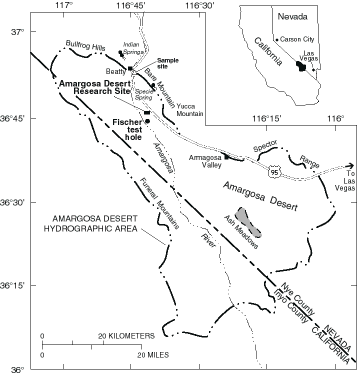
Figure 1. Map showing location of the
Amargosa Desert Research Site, Fischer test hole, and
surface-water sampling locations within the Amargosa Desert
hydrographic area
Figure 2. Map identifying node
distribution within the sampling grid at the Amargosa Desert
Research Site
Figure 3. Map showing tritium
concentration in water vapor collected at the 1.5 m depth within
the sampling grid at the Amargosa Desert Research Site
Figure 4. Graph showing tritium
concentration in water vapor collected from air ports at UZB-2
during April 1994, July 1995, May 1996, and May 1997, and tritium
concentration in water extracted from UZB-1 and UZB-2 core
samples
Table 1. Tritium concentration in water
vapor collected from the shallow unsaturated zone within the
sampling grid at the Amargosa Desert Research Site, May 19-23,
1997
Table 2. Tritium concentration in water
vapor collected from the unsaturated zone at test hole UZB-2 and
at the Fischer test hole at the Amargosa Desert Reserach Site,
May 15-18, 1997
Table 3. Tritium concentration in air and
surface water at and near the Amargosa Desert Research Site, May
15-24, 1997.
Multiply |
By |
To Obtain |
millimeter (mm) |
0.0394 |
inch foot mile gallon cubic foot picocurie per liter |
Elevated tritium concentrations in the unsaturated zone at the Amargosa Desert Research Site (ADRS), immediately south and west of the low-level radioactive-waste burial site south of Beatty, Nevada, have stimulated research of processes that control the transport of tritium in arid unsaturated zones. In May 1997, 58 samples were collected from 1.5 m (meters) depth within a 250 m by 250 m grid at the ADRS. Measured concentrations ranged from 16 ± 9 to 36,900 ± 300 tritium units (TU), decreasing from northeast to southwest, possibly along an ancestral Amargosa River channel.
The 10 air ports at test hole UZB-2 also were sampled, including ports at 57.6, 106.4, and 108.8 m depths that had not been sampled since 1994. Of the remaining seven ports, five were sampled in 1994, 1995, and 1996, and two were sampled in 1994 and 1996. Tritium concentrations at the four ports deeper than 50 m ranged from 791 ± 15 to 1765 ± 29 TU, having increased since they were last sampled. Tritium concentrations at the six ports shallower than 50 m ranged from 367 ± 11 to 1283 ± 20 TU, and appear to have stabilized since 1996.
Tritium concentration in water vapor collected from air within
the creosote bush canopy was 75 ± 9 TU near test hole UZB-2 and
9 ±6 TU near the uncontaminated Fischer test hole, 3.2 km to the
south. Elevated tritium concentration in air near test hole UZB-2
was attributed to plant transpiration removing water from the
unsaturated zone. Nearby surface water tritium concentrations
were 6.3 ± 0.4 TU at Specie Spring, 0.0 ± 0.3 TU at Lower
Indian Springs and at Upper Indian Springs, and 0.8 ± 0.6 TU in
Amargosa River water.
Elevated tritium concentrations in water vapor collected from the unsaturated zone and plants at the Amargosa Desert Research Site (ADRS), south and west of a commercial burial site for low-level radioactive waste near Beatty, Nevada (Prudic and Striegl, 1995; Striegl and others, 1996; Prudic and others, 1997), have caused speculation regarding the exact mechanisms that control tritium transport in arid unsaturated zones. Measured tritium concentrations in the ADRS unsaturated zone are greater than concentrations predicted by applying current tritium transport models to ranges of geological, hydrological and chemical conditions that encompass in situ conditions at the site (Striegl and others,1996). Understanding of tritium transport at the ADRS is complicated by several unknown factors, including tritium source strength; form, timing, and location of tritium contamination; complex geology of the unsaturated zone; and the extent of liquid-water/water-vapor interaction that occurs in the unsaturated zone.
During May 15-24, 1997, as part of ongoing research to understand the mechanisms that control the transport of tritium in arid unsaturated zones, water vapor and liquid water samples were collected from several locations at and near the ADRS for tritium analysis. A primary focus of the field investigation was to measure the spatial distribution of tritium in water vapor approximately 1.5 m below land surface, near the middle of a coarse gravel that underlies surficial silt and sand at the site (Fischer, 1992, p. 19; Striegl and others, 1996). Spatial data on the tritium concentration in the gravel can provide insight regarding the direction and extent of tritium movement at the ADRS and may help in locating possible preferential geological pathways for radionuclide movement, such as ancestral Amargosa River channels. The data also can aid in selecting potential sites of new deep test holes for continued study of the physical and chemical processes that control tritium transport at the ADRS.
Tritium also was measured in water vapor collected from 10 air-sampling ports installed in test hole UZB-2, from above-ground air within the creosote bush (Larrea tridentata) canopy near test hole UZB-2, and from the shallow unsaturated zone and above-ground air within the creosote bush canopy near the uncontaminated Fischer test hole, 3.2 km to the south. Surface-water samples from nearby Specie Spring, Lower Indian Springs, Upper Indian Springs, and the Amargosa River also were collected and analyzed for tritium content.
Water-vapor samples collected from air ports at UZB-2 since 1994 document the recent history of tritium concentration in the unsaturated zone near the test hole (Prudic and Striegl, 1995; Striegl and others, 1996; Prudic and others, 1997). Samples of water vapor and liquid water from above-ground air, the Fischer test hole, nearby springs, and the Amargosa River provide general information on local tritium concentrations.
The purpose of this report is to present and discuss new data
on the spatial distribution of tritium concentration in the
shallow unsaturated zone at the ADRS. The report also adds to the
information base on tritium concentration at test hole UZB-2 and
at nearby uncontaminated sites.
Tritium-in-water-vapor samples were collected within a 250 m
by 250 m grid at the ADRS, directly south and west of a
commercial low-level radioactive-waste burial site, in the
Amargosa Valley, approximately 16 km south of Beatty, Nevada.
They also were collected near the Fischer test hole, 3.2 km south
of the burial site (fig. 1; the Fischer test hole is referred to
as "distant test hole" in Prudic and Striegl, 1995; and
Striegl and others, 1996). Nodes in the 11 by 11 sampling grid
are spaced approximately 25 m apart. Rows 1-11 of the grid are
numbered from north to south, having the northernmost row 1
located at the south fence of the waste burial site. Columns A-K
are lettered from east to west. Node E1 is the southwest corner
of the burial site fence (fig. 2). Test hole UZB-2 is located
between nodes D5 and E5.
 |
| Figure 1. Map showing location of the Amargosa Desert Research Site, Fischer test hole, and surface-water sampling locations within the Amargosa Desert hydrographic area. |
Detailed descriptions of test hole UZB-2 and of the local
geology are summarized in Prudic and Striegl (1995); Striegl and
others (1996); and Prudic and others (1997). Surface-water
tritium samples also were obtained within several kilometers of
the ADRS at Specie Spring, Upper Indian Springs, Lower Indian
Springs, and the Amargosa River (fig. 1).
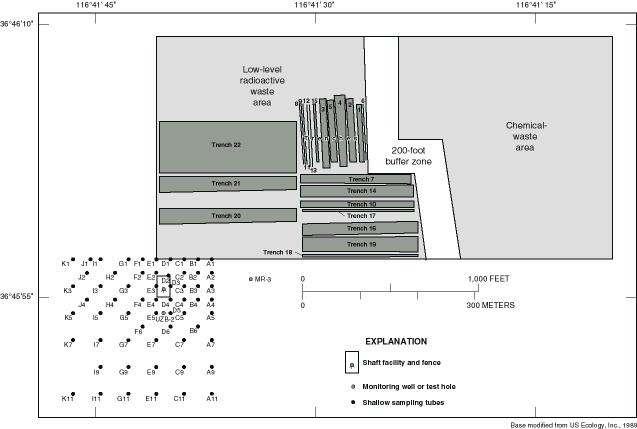 |
| Figure 2. Map identifying node distribution within the sampling grid at the Amargosa Desert Research Site. |
Steel tubes having an outside diameter of 9.5 mm and an inside diameter of 3.2 mm were hand-driven 1.5 m into the unconsolidated deposits at each grid node, or to the point of refusal, if that was slightly shallower. All tubes were hand-driven to at least 1.3 m. Prior to driving, a nail having a narrow shaft and a 9.5 mm head was inserted into the bottom end of each tube to prevent clogging of the tube with sediment as it was driven downward. After driving, the tube was pulled upward about 10 mm to free the nail and to open a space at the bottom of the tube through which air was drawn. Unless otherwise noted, the depth of sampling at the grid nodes is referred to as the "1.5 m depth." Steel tubes also were driven to depths of 0.25, 0.50, 0.75, and 1.0 m at node A-1 and to depths of 0.5, 1.0, and 1.5 m at test hole UZB-2 and the Fischer test hole.
Water vapor was collected by attaching 6 mm inside-diameter Bevaline tubing to the steel tubes or to the nylon tubing connected to the ten UZB-2 air ports, attaching a glass freeze trap to the free end of the tubing, and pulling the unsaturated zone air through the sampling apparatus using a diaphragm air-sampling pump. The freeze traps were chilled in a slurry of dry ice and ethanol or propanol, and water vapor was frozen out of the air stream into the freeze traps (Striegl, 1988). Three to ten milliliters of water were collected at each sample location for tritium analysis at a U.S. Geological Survey isotope laboratory. Sample collection times varied with location from 6 to 24 hours. Pumping rates generally ranged from 1 to 2 liters of air per minute.
Water vapor was freeze-trapped from above-ground air at two
locations and analyzed for tritium content. The locations were
within the creosote bush canopy, 0.8 m above the ground near test
hole UZB-2 between nodes E4 and E5; and 0.9 m above the ground
near the Fischer test hole.
Tritium concentrations for 58 locations at the 1.5 m depth, within the sampling grid, are listed in table 1. Concentrations ranged from 16 ± 9 TU at K11, in the southwest corner of the grid, to 36,900 ± 300 TU at A3, near the northeast corner. Concentration at the Fischer test hole was 11 ± 7 TU at the 1.5 m depth (table 2). Assuming that this value represents natural background levels, all values measured within the sampling grid (with the possible exception of K11) indicate tritium concentrations above expected environmental values. Contours of tritium concentrations within the sampling grid (fig. 3) show a general trend of decreasing concentration from near the northeast corner of the grid to the southwest. A secondary area of high concentration exists in the north-central part of the grid near F1, F2, and G3.
Table 1. Tritium concentration in
water vapor collected from the shallow unsaturated zone within
the sampling grid at the Amargosa Desert Research Site, May
19-23, 1997
Grid location |
Depth below |
Tritium concentration |
Counting uncertainty |
A1 |
0.25 |
3820 |
± 50 |
A2 |
1.5 |
33,800 |
± 300 |
B1 |
1.5 |
18,990 |
± 160 |
C1 |
1.5 |
15,920 |
± 140 |
D1 |
1.5 |
8580 |
± 90 |
E1 |
1.5 |
2810 |
± 40 |
F1 |
1.5 |
10,750 |
± 90 |
G1 |
1.5 |
6340 |
± 60 |
H2 |
1.5 |
5540 |
± 60 |
I1 |
1.5 |
2764 |
± 28 |
J1 |
1.5 |
2166 |
± 24 |
K1 |
1.5 |
340 |
± 10 |
The greatest tritium concentration measured at node A1 was
29,120 ± 250 TU at depth 1.0 m (table 1). The soil has been
reworked by earth moving equipment at sites A1 through E1, which
are along the south fence of the burial site. The sampling tube
at depth 1.0 m at site A1 penetrates the shallow gravel. Measured
tritium concentrations at A1 were nearly 4000 TU greater at the
1.0 m depth than at the 1.5 m depth. The reason for this pattern
is not clear. Increasing concentration with depth would be
expected if migration were upward from a deeper source. However,
because the sampling method requires continuous pumping for
several hours, air is pumped from about 2 m3 of
unsaturated zone for each sample. The volumes of unsaturated zone
influenced by pumping may therefore overlap for closely spaced
samples.
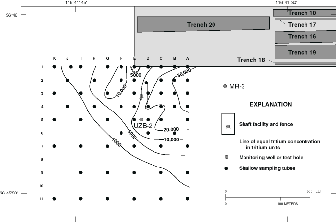 |
| Figure 3. Map showing tritium concentration in water vapor collected at the 1.5 m depth within the sampling grid at the Amargosa Desert Research Site. |
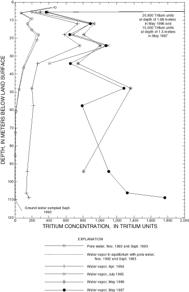
The greatest measured tritium concentration at test hole UZB-2 was 15,510 ± 140 TU at depth 1.5 m (table 2). The tritium concentration versus depth profile at UZB-2 has three depths of high concentration: 15,500 ± 140 TU in the shallow gravel at 1.5 m, 1283 ± 20 TU at 47.9 m, and 1765 ± 29 at 108.8 m (table 2, fig. 4). Lateral movement of tritium from the burial site in the shallow gravel is the likely explanation for high tritium concentrations at the 1.5 m depth.
The combined lateral and vertical movements of tritium to deeper locations at UZB-2 are not yet understood. Following an initial sharp rise in tritium concentrations from 1994 to 1995, measured concentrations at depths of 5.5, 11.9, 18.0, 24.1, and 34.1 m remained fairly constant or decreased between 1996 and 1997 (table 2; Prudic and Striegl, 1995; Striegl and others, 1996; and Prudic and others, 1997). Tritium concentrations increased substantially since they were last sampled in 1994 at depths 57.6, 106.4, and 108.8 m and in 1996 at depth 94.2 m (fig. 4; Prudic and Striegl, 1995; Striegl and others, 1996; and Prudic and others, 1997).
Table 2. Tritium concentration in
water vapor collected from the unsaturated zone at test hole
UZB-2 and at the Fischer test hole at the Amargosa Desert
Research Site, May 15-18, 1997
Depth below |
Tritium concentration |
Sampling uncertainty |
Test hole UZB-2 |
||
0.5 |
12,180 |
± 110 |
Fischer test hole |
||
0.5 |
22 |
± 7 |
One hypothesis to explain the time history of tritium
concentration at UZB-2 is that air injected during the drilling
operation diluted the high-tritium-content subsurface air with
low-tritium-content atmospheric air. This could explain the large
rise in tritium concentration in the years immediately following
drilling and the subsequent stabilization of tritium
concentration in recent years, as ambient subsurface air
gradually mixed back into the area that was injected with
atmospheric air. It is expected that the greatest dilution would
have occurred at depths greater than 91 m. Above that depth, ODEX
air hammer was used for drilling, whereas below that depth, air
rotary, which injects more air into the hole, was used (Prudic
and Striegl, 1995). This hypothesis, however, cannot explain the
large differences between the high tritium concentrations
measured in water vapor in 1996-97 and the low tritium
concentrations measured in liquid water extracted from the
1992-93 core samples (fig. 4; Prudic and others, 1997). These
differences could possibly be explained by the movement of a
tritium pulse over time.
Tritium contamination was not suspected at the ADRS when test
hole UZB-2 was drilled in 1993, so obtaining a continuous tritium
profile from the test hole at the time of drilling was not a
concern (Prudic and Striegl, 1995). A profile showing tritium
concentrations at all depths was constructed in 1996 using water
extracted from archived core samples that were collected from
UZB-2 during drilling in 1993 and from nearby UZB-1 during
drilling in 1992 (fig. 4; Prudic and others, 1997). Below about
50 m, tritium concentrations in the core were close to
concentrations expected for uncontaminated soils.
The immediate and long-term effects of the ODEX air-hammer and the air-rotary drilling at UZB-2 are not known, so it cannot be determined whether measured changes in tritium concentration at the test hole since 1994 are attributable to increased tritium transport past the test hole since drilling or to recovery of the test hole from air injection when the hole was drilled. Migration of the tritium down the test hole also is a possibility, although great care was taken during test hole construction to prevent communication of air and water along the test hole annulus (Prudic and Striegl, 1995).
Water vapor in air collected at 0.8 m above land surface,
within the canopy of a creosote bush located between nodes E4 and
E5, had a concentration of 75 ± 9 TU (table 3). This elevated
concentration is attributed to creosote bush transpiration that
removes water from the shallow unsaturated zone, mixing it with
water vapor in atmospheric air. Striegl and others (1996)
reported concentrations from 2960 ± 50 to 9800 ± 90 TU in
transpiration water from creosote bushes within the area bounded
by grid nodes A1, A5, E1, and E5. Water vapor in air within the
creosote bush canopy at the Fischer test hole had a concentration
of 9 ± 6 TU.
Table 3. Tritium concentration in
air and surface water at and near the Amargosa Desert Research
Site, May 15-24, 1997
Location |
Height above land surface (meters) |
Tritium concentration (tritium units) |
Counting uncertainty (tritium units) |
Air in creosote bush canopy |
|||
| Between nodes E4 and E5 Fischer test hole |
0.8 |
75 |
± 9 |
Surface water |
|||
| Specie Spring Lower Indian Springs Upper Indian Springs Amargosa River |
6.3 |
± 0.4 |
|
Tritium concentrations measured in the unsaturated zone at the Fischer test hole suggest decreasing tritium concentration with depth (22 ± 7 TU at 0.5 m, 13 ± 6 TU at 1.0 m, and 11 ± 7 TU at 1.5 m, table 3). However, all three of these values are statistically similar if the counting errors are considered, so the measured apparent gradient may not be real.
Four local surface-water sources, Specie Spring, Lower Indian
Springs, Upper Indian Springs, and the Amargosa River also were
sampled (table 3). The tritium concentration measured at Specie
Spring of 6.3 TU is probably close to tritium concentrations in
precipitation at the present time. The spring is located at an
elevated site on Bare Mountain (fig.1), and flow paths from the
source area must be short. Samples collected at the other
surface-water sites have concentrations indicative of waters that
were deposited prior to the advent of nuclear testing. These
waters can be presumed to originate in ground waters that have
long flow paths from the point of recharge to the discharge area.
Fischer, J.M., 1992, Sediment properties and water movement through shallow unsaturated alluvium at an arid site for disposal of low-level radioactive waste near Beatty, Nye County, Nevada: U.S. Geological Survey Water-Resources Investigations Report 92-4032, 48 p.
Prudic, D.E., Stonestrom, D.A., and Striegl, R.G., 1997, Tritium, deuterium, and oxygen-18 in water collected from unsaturated sediments near a low-level radioactive-waste burial site south of Beatty, Nevada: U.S. Geological Survey Water-Resources Investigations Report 97-4062, 23 p.
Prudic, D.E., and Striegl, R.G., 1995, Tritium and radioactive carbon (14C) analyses of gas collected from unsaturated sediments next to a low-level radioactive-waste burial site south of Beatty, Nevada, April 1994 and July 1995: U.S. Geological Survey Open-File Report 95-741, 7 p.
Striegl, R.G., 1988, Distribution of gases in the unsaturated zone at a low-level radioactive-waste disposal site near Sheffield, Illinois: U.S. Geological Survey Water-Resources Investigations Report 88-4025, 69 p.
Striegl, R.G., Prudic, D.E., Duval, J.S., Healy, R.W., Landa, E.R., Pollock, D.W., Thorstenson, D.C., and Weeks, E.P., 1996, Factors affecting tritium and 14carbon distributions in the unsaturated zone near the low-level radioactive-waste burial site south of Beatty, Nevada: U.S. Geological Survey Open-File Report 96-110, 16 p.
US Ecology, Inc., 1989, Site stabilization and closure plan for low-level radioactive waste management facility: Beatty, Nev., Radioactive Materials License State of Nevada No. 13-11-0043-02, attachment 1.
The pathname for this document is
<http://water.usgs.gov/lookup/get?ofr97778>
These pages are maintained by S.C. DeMeo
Last modified: Tuesday, May 05, 1998 09:25 AM