
![]()
This report is preliminary and has not been reviewed for conformity with U.S. Geological Survey editorial standards (or with the North America Stratigraphic Code). Any use of trade, product, or firm names is for descriptive purposes only and does not imply endorsement by the U.S. Government.
This entire
Open-File Report 97-28 can be downloaded and viewed with Adobe Acrobat
Reader.
If you do not already have Acrobat Reader, you may download Adobe
Acrobat Reader from this site.
The authors conducted limited site surveys in the Wildhorse and Burbank
oilfields on the Osage Indian Reservation, northeastern Oklahoma. The purpose
was to document salt scarring, erosion, and soil and water salinization,
to survey for radioactivity in oilfield equipment, and to determine if trace
elements and naturally occurring radioactive materials (NORM) were present
in soils affected by oilfield solid waste and produced waters. These surveys
were also designed to see if field gamma spectrometry and field soil conductivity
measurements were useful in screening for NORM contamination and soil salinity
at these sites.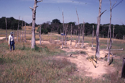
Visits to oilfield production sites in the Wildhorse field in June of 1995 and 1996 confirmed the presence of substantial salt scarring, soil salinization, and slight to locally severe erosion. Levels of radioactivity on some oil field equipment, soils, and road surfaces exceed proposed state standards. Radium activities in soils affected by tank sludge and produced waters also locally exceed proposed state standards. Laboratory analyses of samples from two sites show moderate levels of copper, lead, and zinc in brine-affected soils and pipe scale. Several sites showed detectable levels of bromine and iodine, suggesting that these trace elements may be present in sufficient quantity to inhibit plant growth. Surface waters in streams at two sampled sites exceed total dissolved solid limits for drinking waters. At one site in the Wildhorse field, an EM survey showed that saline soils in the upper 6m extend from a surface salt scar downvalley about 150 m.
(Photo [95k]: Dead oak trees and partly revegetated
salt scar at Site OS95-2 in the Wildhorse field, Osage County, Oklahoma.)
In the Burbank field, limited salt scarring and slight erosion occurs in
soils at some sites and low to moderate levels of radioactivity were observed
in oil field equipment at some sites.
The levels of radioactivity and radium observed in some soils and equipment at these sites are above levels of concern as defined in regulations proposed by the Conference of Radiation Control Program Directors. The volumes of material involved appear to be relatively small for most sites. The lead levels observed in soils affected by tank sludge wastes are about one half of the US Environmental Protection Agency (USEPA) interim remedial action levels used for Comprehensive Environmental Response, Compensation, and Liability Act (CERCLA) and Resource Conservation and Recovery Act (RCRA) sites (400 ppm).
Field gamma spectrometry proved useful in delineating areas where radium has been added to the natural soil by oilfield solid waste and produced water, although the technique does not meet standards of assessment used in the state of Louisiana which require core sampling of 15 cm intervals and radiochemical analysis in the laboratory. Further work is needed to develop field gamma spectrometry as a substitute for the more expensive coring and laboratory analysis. The ratio of radium-228 to radium-226 may hold promise in evaluating the relative ages of NORM contamination at a site.
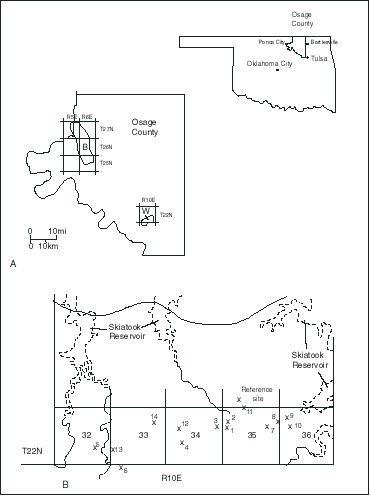 Investigations
on the Osage Indian Reservation (Fig. 1A) are part of a study of the effects
of produced waters on soils, shallow bedrock, surface waters, and shallow
ground waters being conducted by the U.S. Geological Survey. Produced waters
in oil and gas fields are often extremely briny (as much as 35 weight percent
total dissolved solids, Collins, 1975). Original formation waters throughout
Osage County were very briny with most waters ranging from 75,000 to 250,000
ppm TDS (Wright and others, 1957). In addition to high concentrations of
dissolved sodium and chloride, and lesser concentrations of other major
elements, these produced waters and solids formed from them can contain
varying amounts of naturally occurring radioactive materials (NORM, principally
radium-226 and radium-228) and trace elements such as arsenic, barium, selenium,
cadmium, chromium, copper, lead, nickel, silver, zinc, mercury, lithium,
and boron (Collins, 1975). The effects of the surface disposal of produced
waters can include the death of vegetation, soil erosion and siltation of
streams, lakes, and reservoirs, and contamination of soil, ground water
and surface water by salts, hydrocarbons, trace elements, and NORM.
Investigations
on the Osage Indian Reservation (Fig. 1A) are part of a study of the effects
of produced waters on soils, shallow bedrock, surface waters, and shallow
ground waters being conducted by the U.S. Geological Survey. Produced waters
in oil and gas fields are often extremely briny (as much as 35 weight percent
total dissolved solids, Collins, 1975). Original formation waters throughout
Osage County were very briny with most waters ranging from 75,000 to 250,000
ppm TDS (Wright and others, 1957). In addition to high concentrations of
dissolved sodium and chloride, and lesser concentrations of other major
elements, these produced waters and solids formed from them can contain
varying amounts of naturally occurring radioactive materials (NORM, principally
radium-226 and radium-228) and trace elements such as arsenic, barium, selenium,
cadmium, chromium, copper, lead, nickel, silver, zinc, mercury, lithium,
and boron (Collins, 1975). The effects of the surface disposal of produced
waters can include the death of vegetation, soil erosion and siltation of
streams, lakes, and reservoirs, and contamination of soil, ground water
and surface water by salts, hydrocarbons, trace elements, and NORM.
The USEPA estimates that 30 percent of oil and gas production operations in the U.S. may have levels of NORM in brine and brine solids sufficiently elevated to be of concern (USEPA, 1993). One industry estimate suggests that if strict regulatory requirements for assessment and cleanup of NORM were put in place in the U.S., 20 percent of oil production and 8 percent of gas production would become uneconomic (Smith and others, 1995).
As in many producing areas of the U.S., in the early 1900s Osage County produced waters were often dumped on the surface or in nearby washes and streams. This practice later gave way to the use of brine evaporation ponds. Still later, companies injected produced waters for waterflooding and for maintaining field pressures. As regulations governing brine discharges were put into place, injection disposal wells became extensively used. Many injection, waterflooding, and pressure maintenance wells encountered problems with equipment failures, leakage across geologic structures, and leakage up improperly plugged and abandoned older production wells. This history suggests that salt scarring and past contamination of soils and ground and surface waters are likely to be common in the county. Previous deep geophysical surveys had mapped the presence of brine plumes in the subsurface in the Burbank field area (Fitterman, 1985; Raab and Frischknecht, 1985).
A 1989 American Petroleum Institute (API) survey of radioactivity in active U.S. oil production and gas processing equipment included oil production equipment at 115 sites in Osage County (Otto, 1989). The average radioactivity across the county was 87 microRem per hour (mR/hr) above background and the median and 75th percentile values were 4 and 32 mR/hr above background, respectively. The maximum observed value was 3391 mR/hr above background. Slightly more than 25 percent of the oilfield equipment measured in Osage county exceeded the USEPA radioactivity standard used in uranium mine tailings reclamation sites (25 mR/hr above background). High values observed in the API survey occur mostly on separator tanks, water storage tanks, and water lines where brine scale and tank sludge accumulate.
An aeroradiometric survey of Osage County was conducted as part of the National Uranium Resource Evaluation (NURE) survey of the Department of Energy (Texas Instruments, 1978). East-west flightlines spaced at a nominal 6 miles (10 km) were flown across the county. These data show that equivalent uranium values for the eastern part of the county (an area underlain mostly by sandstone and shales) generally range from 1.0-2.0 ppm (0.33-0.67 pCi/g radium-226). In the western part of the county (an area underlain mostly by limestone) equivalent uranium values are generally somewhat higher (1.5-2.5 ppm, 0.5-0.8 pCi/g radium-226). Some anomalies in the profiles are related to the presence of uranium-enriched black shales; however, some substantial equivalent uranium anomalies occur (as much as 10 times background) that have no geologic explanation. The NURE report interpreted these anomalies as caused by "possible Ra-rich oilfield brines". The largest of these anomalies (about 5 pCi/g Ra-226 maximum) occurs over the Wildhorse oilfield.
In the soil survey of Osage County, Bourlier and others (1979) identified "oil-waste land" as one of the soil map units and indicated that 1927 acres (0.1 percent) of the county is underlain by this unit. Our studies of aerial photos and our field inspection of the Wildhorse oilfield suggest that 1) a large number of small areas of active salt scars are not mapped in the soil survey; and 2) extensive areas of probable older salt scars, now revegetated with grasses, were not included in this soil map unit. This suggests that considerably more Osage County acreage is underlain by active and historic salt scars.
This report describes salt scarring and erosion at selected sites in the Wildhorse oilfield, provides information regarding the presence of trace elements in soils in the Wildhorse oilfield, provides survey information for NORM at operations in the Wildhorse and Burbank oilfields, and documents shallow soil salinization at one site in the Wildhorse field.
 |
 |
| |

![]() U.S. Department of the Interior | U.S. Geological Survey
U.S. Department of the Interior | U.S. Geological Survey
URL: http://pubsdata.usgs.gov/pubs/of/1997/ofr-97-0028/OF97-28.html
Page Contact Information: Central Energy Data Management
Questions or Assistance: Contact USGS
Last modified: Wednesday, 07-Dec-2016 16:31:36 EST