EVALUATION OF THE POTENTIAL FOR DEBRIS AND HYPERCONCENTRATED FLOWS IN CAPULIN CANYON AS A RESULT OF THE 1996 DOME FIRE, BANDELIER NATIONAL MONUMENT, NEW MEXICO
By
Susan H. Cannon
Open File Report 97-136
This report is preliminary and has not been reviewed for conformity with U.S. Geological Survey editorial standards (or with the North American Stratigraphic Code). Any use of trade, product, or firm names is for descriptive purposes only and does not imply endorsement by the U.S. Government
Contents
- Abstract
- Introduction
- Debris Flow Initiation and Classification
- Dilute streamflow
- Hyperconcentrated flow
- Debris flow
- Geological, Ecological and Climatological Frameworks
- Geology
- Ecology
- Climate
- June 26, 1996 storm
- August 19-24, 1996 storms
- Remainder of the Monsoon Season
- Influence of Geologic and Geomorphic Factors
- Fire intensity
- Friable bedrock units and cohesionless soils
- Hillslope geometry, smoothness and vegetative cover
- Dry-ravel concentrations
- Hydrophobic soils
- Condition of riparian vegetation
- Condition of fibrous root mat
- Continuity of burn mosaic
- Evidence of Past Debris-Flow Activity
- Debris-Flow Potential
- Recommendations
- References
- Appendix
The Dome fire of April 1996 burned 6684 ha in Bandelier National Monument and the adjacent Sante Fe National Forest. The potential for significant debris- and hyperconcentrated-flow activity in Capulin Canyon is evaluated through 1) a systematic consideration of geologic and geomorphic factors that characterize the condition of the hillslope materials and channels following the fire, 2) examination of sedimentologic evidence for past debris-flow activity in the canyon, and 3) evaluation of the response of the watershed through the 1996 summer monsoon season. The lack of accumulations of dry-ravel material on the hillslopes or in channels, the absence of a continuous hydrophobic layer, the relatively intact condition of the riparian vegetation and of the fibrous root mat on the hillslopes, and the lack of evidence of widespread past debris- and hyperconcentrated-flow activity, even with evidence of past fires, indicate a low potential for debris-flow activity in Capulin Canyon. In addition, thunderstorms during the summer monsoon of 1996 resulted in abundant surface overland flow on the hillslopes which transported low-density pumice, charcoal, ash and some mineral soil downslope as small-scale and non-erosive debris flows. In some places cobble- and boulder-sized material was moved short distances. A moderate potential for debris- and hyperconcentrated-flow activity is identified for the two major tributary canyons to Capulin Canyon based on evidence of both summer of 1996 and possible historic significant debris-flow activity.
The Dome fire was ignited on April 25, 1996 by a campfire abandoned west of the Dome Wilderness on the Jemez District of the Santa Fe National Forest. Due to higher than normal fuel loads, low fuel moisture, and weather and wind patterns, the fire spread rapidly through tinder-dry forest, woodland, and grassland plant communities, and within two days had extended eastward into the Bandelier National Monument. The Dome fire burned approximately 6684 ha of federal lands, including 4750 ha administered by the U.S. Forest Service and 1934 ha within Bandelier (Figure 1) (U.S. Department of Interior, 1996). The effects of the fire were particularly severe in the Boundary Peak and Capulin Canyon areas (Figure 2).
The connection between forest fires and major sedimentation events has been recognized for some time, particularly in southern California where the concept of "fire-flood sequences" was first defined (e.g., Kotak and Kraebel, 1935). Conditions at Bandelier National Monument immediately after the fire were evaluated by the Burned Area Emergency Rehabilitation (BAER) Team; their report identified the potential for debris flows in Capulin Canyon within the Monument, and recommended further evaluation (U.S. Department of Interior, 1996).
Debris-flow susceptibility in a burned watershed depends on the condition of the hillslope materials and channel following the fire, and, most importantly, subsequent rainfall events. Geologic and geomorphic factors that have been identified as contributing to post-fire debris-flow activity are (modified from Spittler et al., 1994):
- Friable bedrock units and cohesionless soils.
- Long, smooth and regular slopes inclined more steeply than 65% and denuded of ground-covering vegetation.
- Concentrations of dry-ravel material mantling steep slopes and infilling tributary channels.
- The development of a continuous layer of water-repellent soil.
- The removal of riparian vegetation in or next to stream channels.
- A destroyed fibrous root mat.
- A continuous burn mosaic.
The presence of these factors, given an appropriate rainstorm, can indicate a high susceptibility to debris flow. Note that the relative importance of each of the factors is unknown, and methods to quantitatively evaluate their possible effects have not been explored. To assess the potential for debris flow as a result of the Dome fire, these conditions were described and qualitatively evaluated at 15 sites in Capulin Canyon (Figure 3, Appendix A). The sites were located to characterize the effect of varying fire intensities, rock, soil, and vegetation types, and slope conditions. In addition, the occurrence of thunderstorms throughout the summer monsoon season made it possible to assess the hillslope and channel response to heavy rainfall events. Finally, the Capulin Creek drainage was examined for evidence of past debris-flow activity to determine if conditions in the drainage are anytime conducive for generating debris flow.

| Figure 1. Location of Bandelier National Monument in New Mexico, and extent of the Dome fire of April 1996 (from BAER report, U.S. Department of the Interior, 1996). |
This report presents the following items:
- Brief descriptions of the two processes by which debris flows initiate, and the classification system used to define debris-flow processes.
- Descriptions of the geological, ecological and climatological frameworks at Bandelier and of the summer rainfall record, with particular attention to the storm of June 26, 1996 and the storm sequence of August 19-25, 1996.
- Descriptions of the influence of fire intensity and of the geologic and
- geomorphic factors listed above on the generation of sediment for debris flows in Capulin Canyon, in part evidenced by the hillslope response to the June storm.
- A description of evidence for past debris-flow activity in the canyon.
- Conclusions regarding the potential for the generation of debris flows in Capulin Canyon.
- Recommendations for short-term recreational use and further evaluation, and discussion
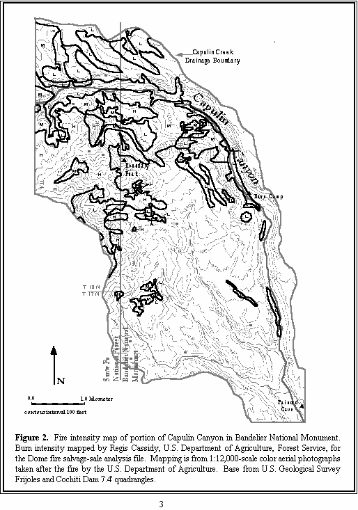
| Figure 2. Fire intensity map of portion of Capulin Canyon in Bandelier National Monument. Burn intensity mapped by Regis Cassidy, U.S. Department of Agriculture, Forest Service, for the Dome fire salvage-sale analysis file. Mapping is from 1:12,000-scale color aerial photographs taken after the fire by the U.S. Department of Agriculture. Base from U.S. Geological Survey Frijoles and Cochiti Dam 7.5’ quadrangles |
Debris-Flow Initiation and Classification
In general, debris flows can initiate by one of two processes: by landsliding or by sediment bulking of surface water flows. Landsliding occurs as either a rotational slump or a translational slide. The material fails as an intact block and then mobilizes into a muddy slurry, the muddy slurry being the debris flow. With this process, the flow path can then be traced up a channel to a landslide-scar source. This type of initiation is triggered by rainfall infiltration into the slope and failure on a discrete failure plane within the hillslope materials (e.g., Campbell, 1975; Cannon, 1988). Sediment bulking occurs when high surface-water flows erode material or incorporate loose material from hillsides or channels; this eventually results in sufficient concentrations of sediment within the flow so that it behaves as a debris flow (e.g., Davies, et al., 1992; Wells, 1987). This is the process most frequently described following forest fires (e.g., Cannon, 1995; Meyer, 1993; Florsheim, et al., 1991).

| Figure 3. Topographic map of portion of Capulin Canyon in Bandelier National Monument. Locations of sites used to assess hillslope conditions are labeled 1 through 15. Rain gage site is labeled IS-1. Letter A denotes eastern-most extent of tributary surface flow generated by the June 26, 1996 storm. Letter B indicates location of summer of 1996 debris-flow deposits that originated in Gallesteo formation colluvium. Letter C marks the location of tributary in which a very fluid debris flow occurred in the summer of 1996. Letter D denotes the location of possible old debris-flow deposits on the canyon floor. Letter E marks the location of fan deposits at the mouths of tributaries. The northern-most fan contains dateable charcoal. Base from U.S. Geological Survey Frijoles and Cochiti Dam 7.5’ quadrangles. |
Debris flow is a member of a classification system based on definition of the sediment-water flow continuum (Pierson and Costa, 1987). In this system, each of the flow types defined represents a continuous range of properties within the sediment-water flow continuum, and the different types of flow are distinguished based on ranges of sediment concentration and rheologic behavior. The three major flow types are briefly described below.
| NEXT | TOP |
| AccessibilityFOIAPrivacyPolicies and Notices | |
| |
|