
![]()
Coal availability in the Hilight quadrangle, Powder River Basin, Wyoming: a prototype study in a western coal field
by Carol L. Molnia, Laura R. H. Biewick, Dorsey Blake, Susan J. Tewalt, M. Devereux Carter (US Geological Survey), and Charlie Gaskill (Bureau of Land Management)
|
Figure 11. Enlargement of coal-correlation diagram A-A\022 from Figure 10; no vertical datum and no horizontal scale. Note variations in thickness in the Main Wyodak coal bed and variations in number of partings. Thickness values shown in feet. See Figure 3 for the location of Line A-A\022. R, Rider Wyodak; M, Main Wyodak; L, Lower Wyodak coal beds. 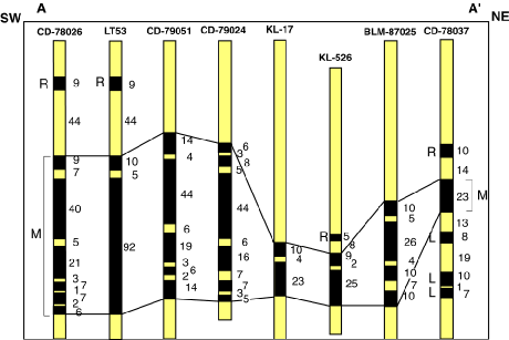
|
U.S. Geological Survey Open-File Report 97-469