OFR 97-492: NURE HSSR Data
National Geochemical Database—Reformatted Data from the National Uranium Resource Evaluation (NURE) Hydrogeochemical and Stream Sediment Reconnaissance (HSSR) Program
By Steven M. Smith
Version 1.40 (2006)
Geochemistry of Oklahoma National Uranium Resource Evaluation Hydrogeochemical and Stream Sediment Reconnaissance Program
Oklahoma Quadrangle Index Map
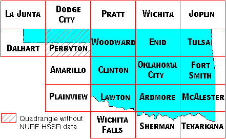
Quadrangles with NURE HSSR data in or adjacent to Oklahoma
- Amarillo Quadrangle, Texas
- Ardmore Quadrangle, Oklahoma, Texas
- Clinton Quadrangle, Oklahoma
- Dalhart Quadrangle, Texas, New Mexico, Oklahoma, Kansas, Colorado
- Dodge City Quadrangle, Kansas, Oklahoma
- Enid Quadrangle, Oklahoma, Kansas
- Fort Smith Quadrangle, Arkansas, Oklahoma
- Joplin Quadrangle, Missouri, Kansas
- La Junta Quadrangle, Colorado
- Lawton Quadrangle, Oklahoma, Texas
- McAlester Quadrangle, Oklahoma, Arkansas
- Oklahoma City Quadrangle, Oklahoma
- Plainview Quadrangle, Texas
- Pratt Quadrangle, Kansas
- Sherman Quadrangle, Texas, Oklahoma
- Texarkana Quadrangle, Texas, Arkansas, Oklahoma, Louisiana
- Tulsa Quadrangle, Oklahoma, Arkansas, Missouri, Kansas
- Wichita Quadrangle, Kansas
- Wichita Falls Quadrangle, Texas, Oklahoma
- Woodward Quadrangle, Oklahoma, Kansas
Quadrangles without NURE HSSR data
Because the NURE program was never completed, there are several quadrangles that do not contain any NURE HSSR data. Those quadrangles that are in or adjacent to Oklahoma are listed here.
- Perryton Quadrangle, Texas, Oklahoma, Kansas
Links Within Open-File Report 97-492
Home Page: USGS National Geochemical Database - NURE HSSR data
History of NURE HSSR Program
Why a new NURE HSSR data format?
On-Line Manual for USGS-Reformatted NURE HSSR Data Files
Frequently Asked Questions Concerning NURE HSSR Data
Selected Publications from the NURE HSSR Program
Go directly to the NURE HSSR Sediment Data Download site.
Go directly to the NURE HSSR Water Data Download site.
Page written by Steven M. Smith (smsmith@usgs.gov)
Version 1.10: July 29, 1999
Version 1.20: August 07, 2000
Version 1.30: September 11, 2001
Version 1.41: February 23, 2006
