
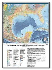
Map Showing Geology, Oil and Gas Fields, and Geologic Provinces of the Gulf of Mexico Region
Links
- Document: Map (8.56 MB pdf)
- Database: Database (10.0 KB zip)
- Metadata: Metadata (56.5 KB zip)
- Read Me: Read Me (11.7 KB txt)
- NGMDB Index Page: National Geologic Map Database Index Page (html)
- Download citation as: RIS | Dublin Core
Abstract
This map was created as part of a worldwide series of geologic maps for the U.S. Geological Survey’s World Energy Project, available on CD-ROM and through the Internet. The goal of the project is to assess the undiscovered, technically recoverable oil and gas resources of the world. Geologic provinces were created for ranking purposes in the World Petroleum Assessment 2000 (U.S. Geological Survey World Energy Assessment Team, 2000). A modified subset of these provinces are shown on the map, based on new bathymetric data and geologic knowledge. Geologic province boundaries are not intended to be taken for country boundaries or exclusive economic zone (EEZ) boundaries. The USGS World Petroleum Assessment 2000 - Description and Results can be found online at: http://pubs.usgs.gov/dds/dds-060. Oil and gas fields are represented by a single geographic point in the center of the field and displays field type (oil or gas) only. The map includes three surface geology datasets, which were modified for display purposes.
Suggested Citation
French, C.D. and Schenk, C.J., 2006, Map showing geology, oil and gas fields, and geologic provinces of the Gulf of Mexico region: U.S. Geological Survey Open-File Report 97-470-L, https://doi.org/10.3133/ofr97470L.
ISSN: 2331-1258 (online)
ISSN: 0196-1497 (print)
Study Area
| Publication type | Report |
|---|---|
| Publication Subtype | USGS Numbered Series |
| Title | Map showing geology, oil and gas fields, and geologic provinces of the Gulf of Mexico region |
| Series title | Open-File Report |
| Series number | 97-470 |
| Chapter | L |
| DOI | 10.3133/ofr97470L |
| Year Published | 2006 |
| Language | English |
| Publisher | U.S. Geological Survey |
| Publisher location | Reston, VA |
| Contributing office(s) | Central Energy Resources Science Center |
| Description | 1 Plate: 36 x 60 inches; Database; Metadata: ReadMe |
| Other Geospatial | Gulf of Mexico region |
| Online Only (Y/N) | N |
| Additional Online Files (Y/N) | Y |
| Google Analytic Metrics | Metrics page |