
![]()
![]()
|
GRIDVECTOR (version 1) : AN ARC/INFO AML PROGRAM TO EXTRACT by Feliks Persits
The following figures show some examples. Figures 1-5 show the GRIDVECTOR application on a fragment of a 1:7,500,000 scale geologic map of relatively poor quality (i.e. pale colors, variable line width, very tiny polygons). Figure 1 shows the input grid with arrows pointing to latitude/longitude lines that are considered to be noise. Other noise features are text labels and a background dot pattern. The final line coverage (after GRIDLINE) in figure 4 shows advantages of the GRIDVECTOR algorithm. Coordinate lines and many of the text labels are completely filtered out. Some of the polygons look completed and are ready for geologic attributing. The results in the lower-left corner are of poor quality; further editing and correcting need to be done before geologic attributing can start because there are many small polygons and small distances between lines in comparison to the GRID filter size. At the same time, in figure 3 (binary image after grid processing which serves as the input for GRIDLINE) the white lines are more contiguous and more like the original. This illustrates the fact that the effectiveness depends on GRIDLINE. Figure 5 shows another run on the same grid, using different parameters; - a higher threshold for dark lines and average slope. There are fewer false lines in this coverage, but at the same time more digitization will be needed. Figure 2 shows an intermediate average slope grid where the white pixels are maximums (arrows point to some). The coordinate lines and many of the text labels have disappeared but much correction and digitization is still needed. Half of the desired lines are present and therefore the same amount of handwork has been saved. The second example shows another GRIDVECTOR application. The goal was to select and trace sea depth contour lines from a gray-scale image (Figure 6) in which areas between the contours are filled in by different patterns. In spite of this image noise, lines on the final coverage (Figure 7) follow the original contours accurately. Minor corrections, like filling in gaps and removing false lines, will still need to be done. Conclusion: GRIDVECTOR has been created as a helpful tool for paper map digitization, that continues to be a most tedious and time-consuming task in new GIS projects. The standard ARC/INFO GRIDLINE or ARCSCAN subsystem can be applied only to binary images and therefore requires handmade mylar copies of maps. GRIDVECTOR provides a more efficient gray-scale scanning method of moving a paper map into ARC/INFO format. |
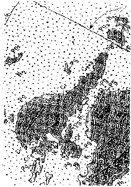 FIG. 1 – A fragment of a 1:7,500,000 scale geologic map of relatively poor quality, i.e. pale colors, variable line width, tiny polygons. Gray-scale scanned image of this fragment has been converted to grid by IMAGEGRID command and used as input for GRIDVECTOR program. Arrows point to a latitude/longitude lines that are considered to be noise. Other noise features are text labels and background dot patterns. |
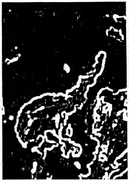 FIG. 2 – An intermediate average slope grid, from map fragment in figure 1, where the white pixels are maximums. Latitude/longitude grid lines and many of the text labels have disappeared. |
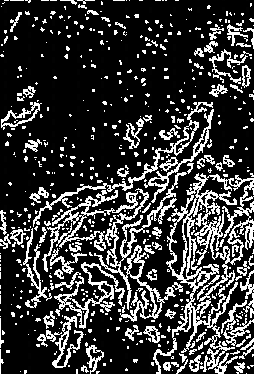 FIG. 3 – Binary grid, from map fragment in figure 1, after completion of input grid processing which serves as the input for GRIDLINE. Noise features including latitude/longitude grid lines are converted to groups of speckles that are in turn removed by the GRIDDESPECKLE command of ARC/INFO. |
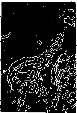 FIG. 4 – Final line and polygon ARC/INFO coverage after GRIDLINE, from map fragment in figure 1. Coordinate lines and many of the text labels are completely filtered out. Some of the polygons look completed and are ready for geologic attributing. The results in the lower-left corner however are of poor quality and further editing a nd correcting needs to be done before geologic attributing can start. |
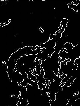 FIG. 5 – Another run on the same grid, as figure 1, using as different parameters: a higher threshold for dark lines and average slope. There are fewer false lines in this coverage, but at the same time more digitization is needed. Map fragment from figure 1. |
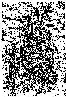 FIG. 6 – A fragment of a map at 1:7,500,000 scale showing sea depth contours that are to be extracted. Areas between the contours are filled in by different patterns. |
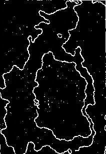 FIG. 7 – Final line ARC/INFO coverage of the map fragment, figure 6. Minor corrections, like filling in gap and removing false lines, will still need to be done. |
| Previous | Next |
U.S. Geological Survey Open-File Report 97-713
| AccessibilityFOIAPrivacyPolicies and Notices | |
 |
|