
DIGITAL-MAP GRIDS OF MEAN-ANNUAL PRECIPITATION FOR 1961-90, AND GENERALIZED SKEW COEFFICIENTS OF ANNUAL MAXIMUM STREAMFLOW FOR OKLAHOMA
Prepared in cooperation with the
Oklahoma Department of Transportation
Oklahoma City, Oklahoma
1997
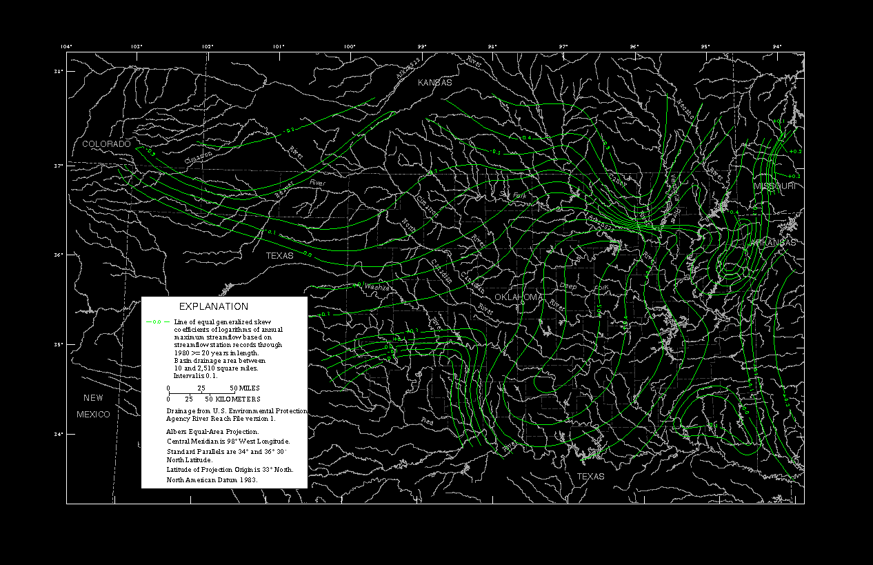
The second data set is a grid of generalized skew coefficients of logarithms of annual maximum streamflow for Oklahoma streams less than or equal to 2,510 square miles in drainage area. This grid of skew coefficients is taken from figure 11 of Tortorelli and Bergman, 1985, "Techniques for estimating flood peak discharges for unregulated streams and streams regulated by small floodwater retarding structures in Oklahoma," U.S. Geological Survey Water-Resources Investigations Report 84-4358. To save disk space, the skew coefficient values have been multiplied by 100 and rounded to integers with two significant digits. The data sets are provided in an ASCII grid format.
The second data set is a grid of generalized skew coefficients
of
logarithms of annual maximum streamflow for Oklahoma streams less than
or equal to 2,510 square miles in drainage area. This grid of skew
coefficients is taken from figure 11 of Tortorelli and
Bergman, (1985). To save disk space, the skew coefficient values have
The U.S. Geological Survey compiled these data sets in
cooperation
with the Oklahoma Department of Transportation.
The "SKEWGRID.ASC" file is compressed with the GZIP utility.
The GUNZIP
utility is an MS-DOS executable program that will
uncompress the data file. The file should first be copied to hard disk.
To uncompress the file, type at the MS-DOS prompt:
This will uncompress the file and restore its original name,
"SKEWGRID.ASC".
The documentation files comply with the Federal Geographic
Data Committee (FGDC) Content Standards for Digital Geospatial
Metadata (Federal Geographic Data Committee, 1994). The
FGDC-compliant metadata files contain detailed descriptions of the
data sets, and include narrative sections describing the procedures
used to produce the data sets in digital form.
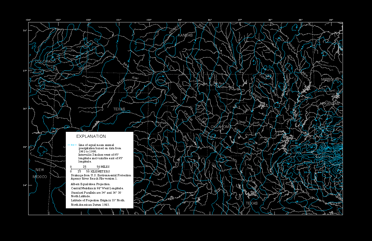
A graphic image also is provided in a Graphics Interchange
Format
(GIF) file. GIF files are easily displayed on a variety of computer
systems using readily available display software. This image provides
a simplified view of the data sets, and may be used for browsing
purposes. The GIF file portrays significantly less spatial resolution
and information content than the actual data sets.
This projection slightly distorts shapes and distances
(scale) in
order to maintain equal-area properties. Scale is true along
the
standard parallels (Snyder, 1987).
The data sets were processed using the ARC/INFO Revision 7.0.3
software package, running on a Data General AViiON workstation. File
names, directories, and pathnames in this document are enclosed in
quotation marks, and type set in upper case. Pathnames use
MS-DOS-style naming conventions, with the "\" character indicating
the
highest-level directory of the diskette.
Daly, C., R.P. Neilson, and D.L. Phillips, 1994, A statistical-
topographic model for mapping climatological
precipitation over
mountainous terrain: Journal of Applied Meteorology,
v. 33,
no. 2, p. 140-158.
Federal Geographic Data Committee, 1994, Content standards for digital
geospatial metadata (June 8): Federal Geographic
Data Committee,
Washington, D.C., 78 p.
Snyder, J.P., 1987, Map projections--A working manual: U.S. Geological
Survey Professional Paper 1395, 383 p.
Tortorelli, R.L., 1997, Techniques for estimating peak-streamflow
frequency for unregulated streams and streams
regulated by small
floodwater retarding structures in Oklahoma:
U.S. Geological
Survey Water-Resources Investigations Report
97-4202, 39 p.
Tortorelli, R.L., and Bergman, D.L., 1985, Techniques for estimating
flood peak discharges for unregulated streams
and streams
regulated by small floodwater retarding structures
in Oklahoma:
U.S. Geological Survey Water-Resources Investigations
Report
84-4358, 85 p.
FILE FORMATS
The two data sets are provided in an ASCII grid file format.
The
first six lines of each file contain the number of columns and rows
in
the grid, the map coordinates of the lower-left grid cell, the grid
cell size in meters, and the value used to indicate a missing value
(-9999, also called "NODATA").
GUNZIP -aN SKEWGRID.GZ
DATA ORGANIZATION
GEOMETRIC REGISTRATION
The Albers Equal Area map projection (Snyder, 1987) is used
for the
data sets. This projection is appropriate for maps of Oklahoma
because of the visual presentation and equal-area characteristic,
which facilitates areal analysis. The projection is cast on the
North
American Datum of 1983. The following table provides map projection
information.
[GRS1980, Geodetic Reference System; 1980 NAD83, North American Datum 1983]
Projection parameters:
Spheroid GRS1980 Datum NAD83 First standard parallel 34 00 00 North Second standard parallel 36 30 00 North Central meridian 98 00 00 West Latitude of projection origin 33 00 00 North Coordinate system parameters:
False easting 0 False northing 0 Planimetric units of measure meters NOTES
The use of trade names is for descriptive purposes only, and does
not imply endorsement by the U.S. Government.
REFERENCES CITED
AccessibilityFOIAPrivacyPolicies and Notices
![]()
