Open-File Report 98-340
Cynthia Dusel-Bacon (U.S. Geological Survey, Menlo Park, CA), Jason R. Bressler (WGM, Inc., Anchorage, AK), Hidetoshi Takaoka (Sumitomo Metal Mining Company, Vancouver, B.C.), James K. Mortensen (University of British Columbia, Vancouver, B.C.), Douglas H. Oliver (Southern Methodist University, Dallas, TX), Joel S. Leventhal (U.S. Geological Survey, Denver, CO), Rainer J. Newberry (University of Alaska, Fairbanks, AK), and Thomas K. Bundtzen (Pacific Rim Geological Consulting, Fairbanks, AK)
This report is preliminary and has not been reviewed for conformity with U.S. Geological Survey editorial standards or with the North American Stratigraphic Code. Any use of trade, product, or firm names is for descriptive purposes only and does not imply endorsement by the U.S. Government.
Metamorphosed continental margin strata in the Yukon-Tanana Upland of east-central Alaska are thought to be correlative, on the basis of stratigraphic similarities and sparse Mississippian U-Pb zircon and fossil ages (Mortensen, 1992), with middle Paleozoic metasedimentary and metavolcanic rocks in the eastern Alaska Range and in western and southeastern Yukon. Furthermore, rocks in the northern Yukon-Tanana Upland may correlate across the Tintina fault with unmetamorphosed counterparts in the Selwyn Basin (Murphy and Abbott, 1995).
Volcanic-hosted (VMS) and sedimentary exhalative (sedex) massive sulfide occurrences are widely reported for these other areas (green-colored unit of fig. 1) but, as yet, have not been documented in the Alaskan part of the Yukon-Tanana Upland. Recent discoveries of VMS deposits in Devono-Mississippian metavolcanic rocks in the Finlayson Lake area of southeastern Yukon (Hunt, 1997) have increased the potential for finding VMS deposits in rocks of similar lithology and age in the Yukon-Tanana Upland of Alaska. Restoration of 450 km of early Tertiary dextral movement along the Tintina fault juxtaposes these two areas.
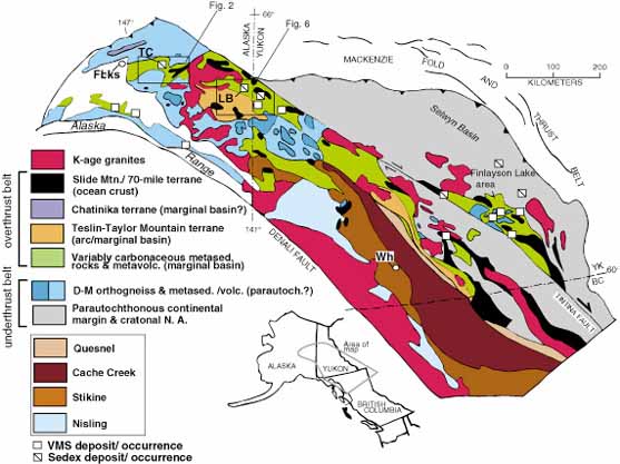
Figure 1. Tectonic elements of the northern Cordillera showing location of VMS and sedex deposits and occurrences within greenschist-facies variably carbonaceous metasedimentary rocks and associated metavolcanic rocks. Fbks, Fairbanks; Wh, Whitehorse; TC, Teuchet Creek drill site; LB, Liberty area of zinc mineralization.
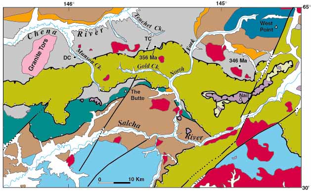
Figure 2. Geologic map of the northern Big Delta quadrangle (modified from Weber and others, 1978) showing location of Teuchet Creek (TC) and Drone Creek (DC) drill sites and U-Pb zircon crystallization ages of felsic metavolcanic rocks.
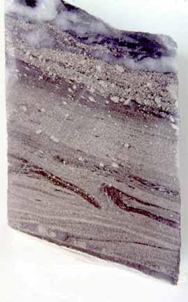
Figure 3A. Finely laminated pyrite in drill core from Teuchet Creek. Note larger pyrite porphyroblasts and folding visible in carbonaceous layers. Sample TC4-673.4'; core is 4.8 cm wide.
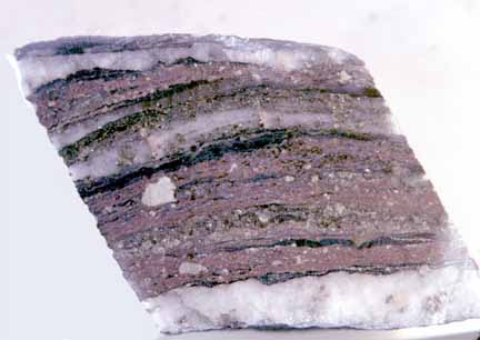
Figure 3B. Sphalerite-rich interval in drill core from Teuchet Creek. Note threadlike wisps of silvery galena, brassy pyrite porphyroblasts, and concordant quartz veins. Sample TC4-670'; core is 4.8 cm wide.
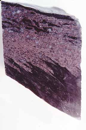
Figure 3C. Five-cm thick layer of folded sphalerite and quartz in drill core from Drone Creek. Sample DC3-277'; core is 4.8 cm wide.
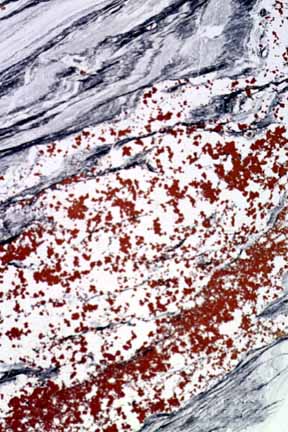
Figure 3D. Photograph of entire thin section made from core shown in 3C. Note concentration of sphalerite (red-brown) in quartz-rich, graphite-poor layer. Height of photo is about 35 mm.
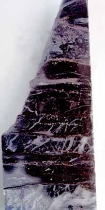
Figure 4A. Siliceous black slate showing truncation of vertical quartz veins along low-angle shear planes. Note laminae of golden pyrite and reddish sphalerite (top of photo). Sample TC5-638'; core is 4.8 cm wide.
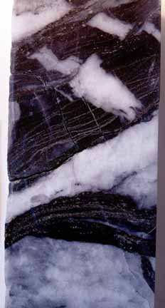
Figure 4B. Pyrite laminae in graphitic slate cut by early quartz veins and concordant to later ones. Sample TC4-690'; core is 4.8 cm wide.
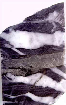
Figure 4C. Pyrite concentrated within shear band that truncates quartz veins in graphitic slate. Sample TC4-691'; core is 4.8 cm wide.
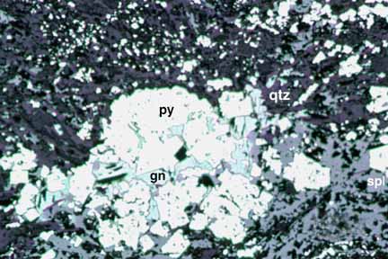
Figure 5A. Reflected light (plane polarized) photomicrograph showing comminution of pyrite porphyroblast (top of photo) to form disseminated pyrite fragments. Note cleavage pits in interstitial galena. Sample TC5-400'; width of photo 1.72 mm.
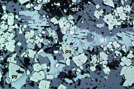
Figure 5B. Reflected light (plane polarized) photomicrograph showing typical texture of sulfide-rich intervals with subidiomorphic pyrite, interstitial galena, and amorphous sphalerite. Pyrrhotite occurs in trace amounts. Sample TC4-674.6'; width of photo 1.72 mm.
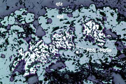
Figure 5C. Reflected light (plane polarized) photomicrograph showing wormy selenium-rich galena within a sphalerite layer. Amount of Se substituted for S in sample ranges from 4 to 37 atom percent. Sample TC5-638'; width of photo 1.72 mm.
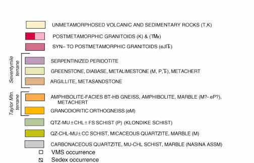
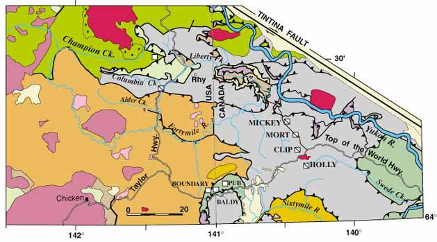
Figure 6. Simplified geologic map of the Liberty area (modified from Foster, 1992, and Mortensen, 1988).
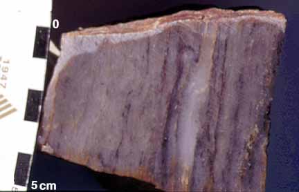
Figure 7A. Sample of celsian quartzite with thin lenses and laminae of sphalerite (dark gray in photo). Sample 96ADb 32c.
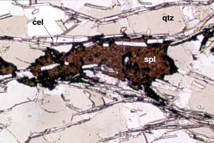
Figure 7B. Transmitted light (plane polarized) photomicrograph of sample shown in fig. 7A showing sphalerite lenses and colorless, prismatic celsian (a barium silicate). Width of photo 0.86 mm.
The northernmost locality consists of variably rusty-weathering, tan to pale gray, slightly muscovitic and carbonaceous quartzite (88 percent SiO2 ) exposed in outcrop and landslide debris just east of the mouth of Columbia Creek. Interlayered with the quartzite are 10-20 cm-thick layers of more muscovite-rich quartzite including some layers of muscovite schist. These layers may have originated as felsic tuffs. The sulfides (amber-brown sphalerite>>galena, chalcopyrite) occur within the quartzite in discontinuous lenses 1-2 cm thick (fig.8).
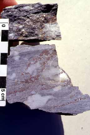
Figure 8. This grab sample of sphalerite-bearing quartzite yielded 8.1 percent Zn, 100 ppm Cd, 38 parts per billion (ppb) Au, and 132 ppm Hg. Sample 96ADb 63.
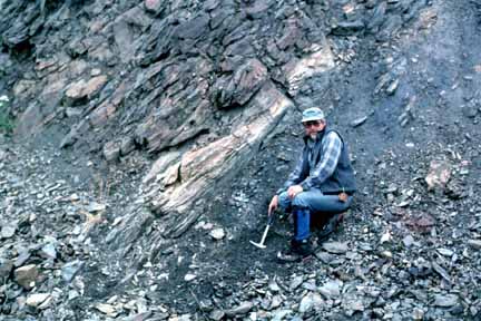
Figure 9A. Jim Mortensen poses at the MORT occurrence (location shown on fig. 6). Sample of fig. 9B was collected from light-colored, folded quartz-rich layer.
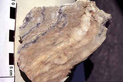
Figure 9B. This sample of cerussite-bearing quartzite yielded 4.3 percent Pb, 54 g/t Ag, and 60 ppb Au. Sample 96ADb41b.
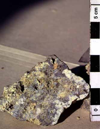
Figure 10. This supergene grab sample from the Lead Creek prospect yielded 2,330 ppb Au, 2126 g/t Ag, >10,000 ppm As, >100 ppm Cd, 1,420 ppm Cu, 10.8 percent Pb, and >10,000 ppm Sb. Sample 96ADb 49.
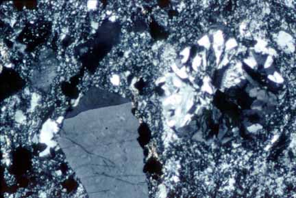
Figure 11. Transmitted light photomicrograph (crossed polars) of Permian-aged metarhyolite. A pyroclastic origin for the metarhyolite is suggested by: 1) the presence of an approximately 1-mm granophyre clast (right-hand half of photo); 2) evidence of broken phenocrysts; and 3) the absence of glomerocrysts, common in lava flows or shallow intrusions. Sample 96ADb 47b; width of photo 0.86 mm.
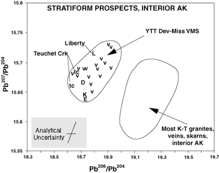
Figure 12. Lead isotopic data for sulfides from east-central Alaska (published data from Church and others, 1987, and Newberry and others, 1997; unpublished 1997 data for galena from Chena Slate Belt (Teuchet Creek drill core) and sphalerite from quartzite in Liberty area from J.K. Mortensen; Abbreviations: v, VMS deposits of the Bonnifield District, Alaska Range; K, Lloyd Prospect, Kantishna; E, mineralized boulder in dredge tailings, Chatanika eclogite terrane; D, Deer Creek, Eagle area.
2. Mineralization in Nasina-age rocks of the CSB and the Liberty area may be similar in age and tectonic and (or) sedimentary setting to sediment-hosted Zn-Pb deposits in the Selwyn Basin-Kechika Trough farther east that occur in fine to coarse black clastic rocks of the Middle Devonian to Mississippian Earn Group.
3. The variety of metals and host rocks at the Lead Creek prospect may indicate multiple episodes of mineralization. Pb- and Ag-enriched siliceous nodules in carbonaceous schist and metachert are perhaps of diagenetic origin. However, the presence of a feldspar porphyry dike anomalous in Pb and As, the high Pb, Sb and As in oxidized material, and the presence of quartz-galena veins, contact metamorphism and sulfide-bearing intrusions in the immediate area suggest that some metals were remobilized or introduced during a later magmatic hydrothermal event.
4. The discovery of a Permian-age metarhyolite in the Liberty area expands the potential for stratiform mineralization to include Permian VMS deposits.
Dusel-Bacon, C., Bressler, J.R., Takaoka, H., Mortensen, J.K., Oliver, D.H., Leventhal, J.S., Newberry, R.J., and Bundtzen, T.K., 1997, Stratiform massive sulfides in the Yukon-Tanana Upland of Alaska: Are they there? [abs.]: Abstracts for the Alaska Miners Association 1997 Meeting, Anchorage, Alaska, p. 24-26.
Dusel-Bacon, C., Bressler, J.R., Takaoka, H., Mortensen, J.K., Oliver, D.H., Leventhal, J.S. Newberry, R.J., and Bundtzen, T.K., 1998a, Stratiform zinc-lead mineralization in Nasina assemblage rocks of the Yukon-Tanana Upland in east-central Alaska [abs.]: Pathways '98, Extended Abstracts Volume: British Columbia & Yukon Chamber of Mines, p. 170-173.
Dusel-Bacon, C., Wooden, J.L., Mortensen, J.K., Bressler, J.R., Takaoka, H., Oliver, D.H., Newberry, R., and Bundtzen, T.K., 1998b, Metamorphic-hosted mineralization in the Yukon-Tanana Upland, Alaska [abs.]: Extended abstracts of the 16th Biennial Conference on Alaskan Mining, March 2-7, 1998, Fairbanks, Alaska Miners Association, p. 16-18.
Foster, H.L., 1992, Geologic Map of the eastern Yukon-Tanana Region, Alaska: U.S. Geological Survey Open-File Report 92-313, 26 p.
Hunt, J.A., 1997, Massive sulphide deposits in the Yukon-Tanana and adjacent terranes. in: Yukon exploration and Geology, 1996, Exploration and Geological Services Division, Yukon, Indian and Northern Affairs Canada, p. 35-45.
Menzie, W.D., and Foster, H.L., 1978, Metalliferous and selected nonmetalliferous mineral resource potential in the Big Delta quadrangle, Alaska: U.S. Geological Survey Open-File Report 78-529D.
Mortensen, J.K., 1988, Geology Southwestern Dawson Map area: Geological Survey of Canada Open-File 1927, scale 1:250,000.
Mortensen, J.K., 1992, Pre-mid-Mesozoic tectonic evolution of the Yukon-Tanana terrane, Yukon and Alaska: Tectonics, v. 11, p. 836-853.
Murphy, D.C., and Abbott, G., 1995, Northern Yukon-Tanana terrane: The equivalent of Yukon's western Selwyn Basin offset along the Tintina fault?: Geological Society of America Abstracts with Programs, v. 27, no. 5, p. 26.
Newberry, R.J., Crafford, T.C., Newkirk, S.R., Young, L.E., Nelson, S.W., and Duke, N.A., 1997, Volcanogenic massive sulfide deposits of Alaska: Economic Geology Monograph 9, p. 120-150.
Schmidt, J.M., 1997, Shale-hosted Zn-Pb-Ag and barite deposits of Alaska: Economic Geology Monograph 9, p. 35-65.
Smith, T.E., Robinson, M.S., Weber, F.R., Waythomas, C.W., and Reifenstuhl, R.R., 1994, Geologic map of the upper Chena River area, eastern Interior Alaska: Alaska Division of Geological and Geophysical Surveys Professional Report 115, scale 1:63,360, 19 p.
U.S. Bureau of Mines, 1995, Final Report of the Mineral Resource Evaluation of the Bureau of Land Management Black River and Fortymile River Subunits: U.S. Bureau of Mines Open-File Report 79-95. 69 p.
Weber, F.R., Foster, H.F., Keith, T.E.C., and Dusel-Bacon, Cynthia, 1978, Preliminary geologic map of the Big Delta quadrangle, Alaska: U.S. Geological Survey Open-File Report 78-529-A, scale 1:250,000.

![]() U.S. Department of the Interior |
U.S. Geological Survey
U.S. Department of the Interior |
U.S. Geological Survey
URL: http://pubsdata.usgs.gov/pubs/of/1998/0340/intro.html
Page Contact Information: GS Pubs Web Contact
Page Last Modified: Wednesday, 07-Dec-2016 16:50:49 EST