Open-File Report 98-484
 Back to Satellite Imagery Page |
  Home
Home
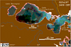
Below are images derived from the Advanced Very High Resolution Radiometer (AVHRR) instrument onboard NOAA polar orbiting satellites. Channel 2 (near-IR) is displayed in red, while channel 1 (visible) is displayed in green and blue. The algal "scum" floating on the surface of Lake Pontchartrain appears as pink or red due to its high reflectance in the near-infrared.
The thin red edge along the shore in most images is vegetation at the coast that is not masked out. However, on June 14, the bulk of the bloom had moved to the south shore near New Orleans.

![]() U.S. Department of the Interior |
U.S. Geological Survey
U.S. Department of the Interior |
U.S. Geological Survey
URL: http://pubsdata.usgs.gov/pubs/of/1998/0484/html/algal.html
Page Contact Information: GS Pubs Web Contact
Page Last Modified: Thursday, 17-Apr-2025 19:28:56 EDT

 July 2, 1997
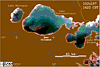 July 10, 1997
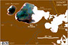 July 11, 1997
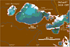 June 4, 1997
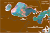 June 12, 1997
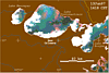 June 13, 1997
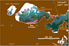 June 14, 1997
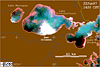 June 22, 1997