Open-File Report 98-484
 Back to Satellite Imagery Page |
  Home
Home
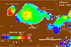
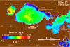
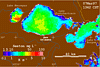
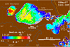
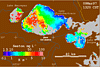
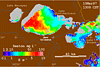
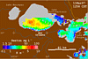
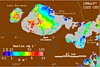
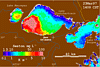
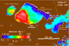
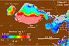
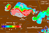
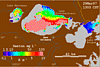
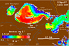
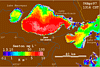
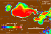
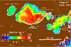
These images of Lake Pontchartrain, Louisiana, were derived from data collected by the Advanced Very High Resolution Radiometer (AVHRR) onboard NOAA polar-orbiting weather satellites. Water reflectance measured in the visible and near-IR wavelengths are determined with corrections for atmospheric effects, and converted to provisional estimates of suspended sediment concentration (seston) and diffuse attenution coefficient (K). These values have not been validated and are provided for context only. Clouds are masked in gray; land in brown.
Due to the recent Midwest flooding, the Bonnet Carre Spillway was opened at approximately 80% maximum on March 17, 1997. The Bonnet Carre Spillway connects the Mississippi River to Lake Pontchartrain and enters the lake in the southwest corner, half-way between Lake Maurepas and New Orleans. These images illustrate the increase in suspended material in the lake as a result of the diversion of flood waters.

![]() U.S. Department of the Interior |
U.S. Geological Survey
U.S. Department of the Interior |
U.S. Geological Survey
URL: http://pubsdata.usgs.gov/pubs/of/1998/0484/html/bonnet.html
Page Contact Information: GS Pubs Web Contact
Page Last Modified: Thursday, 17-Apr-2025 19:28:43 EDT