| Inventory Data: | World glacier inventory - status 1988 | |
| Fluctuations Data: | Fluctuations of Glaciers 1959-1965 (Vol. I) | |
| Fluctuations of Glaciers 1965-1970 (Vol. II) | ||
| Fluctuations of Glaciers 1970-1975 (Vol. III) | ||
| Fluctuations of Glaciers 1975-1980 (Vol. IV) | ||
| Fluctuations of Glaciers 1980-1985 (Vol. V) | ||
| Fluctuations of Glaciers 1985-1990 (Vol. VI) | ||
| Fluctuations of Glaciers 1990-1995 (Vol. VII)* | ||
| Glacier Mass Balance Bulletin No. 1 (1988-1989) | ||
| Glacier Mass Balance Bulletin No. 2 (1990-1991) | ||
| Glacier Mass Balance Bulletin No. 3 (1992-1993) | ||
| Glacier Mass Balance Bulletin No. 4 (1994-1995) | ||
| *to be published by the end of 1997 |
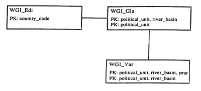
| Fig. 1 | Database scheme for the World Glacier Inventory data. PK means primary key and FK means foreign key. |
| Table 3.1 | Countries and mountain ranges / regions from which detailed inventory data exist, the number of loaded glaciers and data quality. 'Y' means that data exist but have not yet been entered into the database; 'complete' that the whole country is covered. |
| Country (Denotation of Political State) and Mountain Ranges / Regions | Number of Loaded Glaciers | Data Quality / Remarks |
|---|---|---|
Afghanistan (AF)
| Y | |
Argentina (AR)
| 2,706 | Unchecked |
| Austria (A) - complete - | 925 | Checked |
| Bhutan (BH) - complete - | Y | |
Bolivia (RB)
| 1,969 | Checked |
Canada (CD)
| 14,964 | Unchecked |
Chile (RC)
| 1,294 | Unchecked |
China (CN)
| 12,183 | Unchecked; Survey year partly missing |
| CIS (SU) - complete - | 20,908 | Unchecked; Survey year missing |
Columbia (CO)
| Y | |
| Ecuador (EC) - complete - | 113 | Unchecked |
| France (F) - complete - | 1,130 | Checked |
| Germany (D) - complete - | 5 | Checked |
Greenland (GL)
| 45 | Checked |
| Iceland (IS) - announced - | Y | |
India (IN)
| Y | |
| Indonesia (RI) - complete - | Y | |
| Iran (IR) | - | |
| Italy (I) - complete - | 1,379 | Checked |
| Japan (J) - complete - | Y | |
| Kenya (KN) - complete - | Y | |
| Mexico (MX) - complete - | Y | |
| Mongolia (MG) | - | |
Nepal (NP)
| 130 | Checked |
| New Zealand (NZ) - complete - | 3,153 | Checked |
| Norway (N) - complete - | 2,998 | Checked |
Pakistan (PE)
| 69 Y | Checked |
Peru (PE)
| 1,679 | Checked |
| Spain (E) - complete - | 31 | Checked |
| Sweden (S) - complete - | 303 | Checked |
| Switzerland (S) - complete - | 1,828 | Checked |
| Tanzania (TZ) - complete - | Y | |
| Turkey (TR) | - | |
| Uganda (UG) - complete - | Y | |
United States (US)
| 2,519 | Unchecked |
| Venezuela (VZ) - complete - | Y | |
| TOTAL | 70,055 |
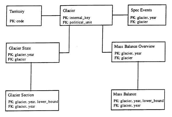
| Fig. 2 | Database scheme for the Fluctuations of Glaciers data. PK: means primary key and FK: means foreign key |
| Table 2 | Countries and count of glaciers within the Fluctuations of Glaciers (FoG) database and within the Glacier Mass Balance Bulletin No. 4 (MBB 4). |
| Country | FoG (Count of Glaciers With Data Within the Database) | MBB 4 (Count of Glaciers With Data in the Publication) |
|---|---|---|
| Antarctica | 39 | |
| Argentina | 10 | |
| Australia | 16 | |
| Austria | 142 | 8 |
| Bolivia | 2 | 2 |
| Canada | 107 | 4 |
| Chile | 36 | |
| China | 38 | 1 |
| Colombia | 20 | |
| France | 11 | 2 |
| Germany | 5 | |
| Greenland | 15 | |
| CIS | 177 | 9 |
| Iceland | 62 | 7 |
| India | 5 | |
| Indonesia | 6 | |
| Italy | 276 | 2 |
| Japan | 2 | |
| Kenya | 13 | 1 |
| Mexico | 2 | |
| Nepal | 14 | |
| New Zealand | 83 | |
| Norway | 52 | 14 |
| Pakistan | 37 | |
| Peru | 10 | |
| Poland | 4 | |
| Spain | 33 | 1 |
| Sweden | 21 | 4 |
| Switzerland | 118 | 2 |
| Uganda | 1 | |
| United Kingdom | 33 | |
| United States | 197 | 3 |
| Venezuela | 1 | |
| TOTAL | 1,555 | 60 |
HAEBERLI, W. AND HOELZLE, M. (1995): AppIication of inventory data for estimating characteristics of and regional climate change effects on mountain glaciers - a pilot study with the European Alps. Annals of Glaciology 21, p. 206-212.
HOELZLE, M. AND TRINDLER, M. (in press): Data management and application. In: Into the Second Century of World Glacier Monitoring - Prospects and Strategies (Haeberli W., Hoelzle, M. and Suter, S.; eds.). UNESCO publishing, Paris.
IAHS(ICSI)/UNEP/UNESCO (1988): Fluctuations of Glaciers 1980-1985 (Haeberli, W. and Müller, P.; eds.), Paris.
IAHS(ICSI)/UNEP/UNESCO (1989): World glacier inventory - status 1988 (Haeberli, W., Bösch, H., Scherler, K, Østrem, G. and Wallén, C. C.; eds.). Nairobi.
IAHS(ICSI)/UNEP/UNESCO (1991): Glacier mass balance bulletin no. 1 (Haeberli, W. and Herren, E.; eds.). World Glacier Monitoring Service, ETH Zurich.
IAHS(ICSI)IUNEP/UNESCO (1993a): Fluctuations of Glaciers 1985-1990 (Haeberli, W. and Hoelzle, M.; eds.), Paris.
IAHS(ICSI)/UNEP/UNESCO (1993b): Glacier mass balance bulletin no. 2 (Haeberli, W., Herren, E. and Hoelzle, M.; eds.). World Glacier Monitoring Service, ETH Zurich.
IAHS(ICSI)/UNEP/UNESCO (1994): Glacier mass balance bulletin no. 3 (Haeberli, W., Hoelzle, M. and Bösch, H.; eds.). World Glacier Monitoring Service, ETH Zurich.
IAHS(ICSI)/UNEP/UNESCO (1996): Glacier mass balance bulletin no. 4 (Haeberli, W., Hoelzle, M. and Suter, S.; eds.). World Glacier Monitoring Service, University of Zurich and ETH Zurich.
IAHS(ICSI)/UNEP/UNESCO (in preparation): Fluctuations of Glaciers 1990-1995 (Haeberli, W., Hoelzle, M., Suter, S. and Frauenfelder, R.; eds.). World Glacier Monitoring Service, University of Zurich and ETH Zurich.
IAHS(ICSI)/UNESCO (1967): Fluctuations of Glaciers 1959-1965 (Kasser, P.; ed.), Paris.
IAHS(ICSI)/UNESCO (1973): Fluctuations of Glaciers 1965-1970 (Kasser, P.; ed.), Paris.
IAHS(ICSI)/UNESCO (1977): Fluctuations of Glaciers 1970-1975 (Müller, F.; ed.), Paris.
IAHS(ICSI)/UNESCO (1985): Fluctuations of Glaciers 1975-1980 (Haeberli, W.; ed.), Paris.
| A1 | The table and item list for the World Glacier Inventory (WGI) database |
| Table A1.1 WGI_Edi | |||
|---|---|---|---|
| Ctr_Code | Varchar2(2) | Not Null/PK | Country Code |
| Edi_Year | Number(4) | Year of the Edition | |
| Edi_Name | Varchar2(20) | Editor names | |
| Edi_Adr | Varchar2(30) | Editor addresses | |
| Table A1.2 WGI_Gla | |||
|---|---|---|---|
| Political_Unit | Varchar2(2) | Not Null/PK | Political Unit part of the WGI-number (position 1 and 2) |
| River_Basin | Varchar2(5) | Not Null/PK | Code for the determination of the hydrological catchment areas (Position 3 designates the continent, positions 4 to 7 are for the drainage code) |
| Free_Position | Varchar2(2) | Free ly chosen number (Position 8 and 9) | |
| Local_Code | Varchar2(3) | local Code helps to make WGI-number clear (Position 10 and 12) | |
| Vaw_Add_Code | Number(3) | Not Null/PK | Additional Code to clear double WGI-numbers |
| Name | Varchar2(16) | Name | |
| Card_Point_Lat | Varchar2(1) | Cardinal point (N or S) | |
| Degrees_Lat | Number(2) | Latitude in degrees | |
| Minutes_Lat | Number(4,2) | Latitude in minutes and seconds | |
| Card_Point_Lon | Varchar2(1) | Cardinal point (E or W) | |
| Degrees_Lon | Number(3) | Longitude in degrees | |
| Minutes_Lon | Number(4,2) | Longitude in minutes and seconds | |
| Coordinates | Varchar2(15) | Coordinates | |
| Nr_States | Number(1) | Number of independant states | |
| Official_Rem | Varchar2(255) | Official remarks | |
| Internal_Rem | Varchar2(255) | Internal remarks | |
| Fluctu_Key | Number(5) | Reference Key to the FoG | |
| Table A1.3 WGI_Var | |||
|---|---|---|---|
| Political_Unit | Varchar2(2) | Not Null/PK | Political Unit part of the WGI-number (position 1 and 2) |
| River_Basin | Varchar2(5) | Not Null/PK | Code for the determination of the hydrological catchment areas (Position 3 designates the continent, positions 4 to 7 are for the drainage code) |
| Free_Position | Varchar2(2) | Free ly chosen number (Position 8 and 9) | |
| Local_Code | Varchar2(3) | Local Code helps to make WGI-number clear (Position 10 and 12) | |
| VAW_Add_Code | Number(3) | Not Null/PK | Additional Code to clear double WGI-numbers |
| Year | Number(4) | Not Null/PK | Year of the map or photo year |
| Nr_Drainage_B | Number(1) | Number of drainage basins | |
| Map_Scale | Number(4) | Map scale | |
| Photo_Type | Varchar2(1) | Photo type | |
| Photo_Year | Number(4) | Photo year | |
| Total_Area | Number(8,3) | Total surface area | |
| Area_Currancy | Varchar2(1) | Accuracy rating of the area | |
| State_Area | Number(8,3) | Total area in the state concerned | |
| Exposed_Area | Number(8,3) | Total exposed surface area | |
| Ablation_Area | Number(8,3) | Ablation area | |
| Mean_Width | Number(4,1) | Mean width | |
| Mean_Length | Number(4,1) | Mean length | |
| Max_Len_Tot | Number(4,1) | Maximum length total | |
| Max_Len_Expo | Number(4,1) | Maximum length exposed | |
| Max_Len_Abla | Number(4,1) | Maximum length ablation area | |
| Expos_Acc_Area | Varchar2(2) | Exposition accumulation area | |
| Expos_Abl_Area | Varchar2(2) | Exposition ablation area | |
| Highest_Elev | Number(4) | Highest Elevation | |
| Median_Elev | Number(4) | Median Elevation | |
| Lowest_Elev_Tot | Number(4) | Lowest elevation total | |
| Lowest_Elev_Exp | Number(4) | Lowest elevation exposed | |
| Mean_Elev_Acc | Number(4) | Mean elevation accumulation area | |
| Mean_Elev_Abl | Number(4) | Mean elevation ablation area | |
| Prim_Classific | Varchar2(1) | Primary classification | |
| Form | Varchar2(1) | Form | |
| Frontal_Chars | Varchar2(1) | Frontal characteristics | |
| Longi_Prof | Varchar2(1) | Longitudinal profile | |
| Source_Nouri | Varchar2(1) | Major source of nourishment | |
| Acti_Tongue | Varchar2(1) | Activity of the tongue | |
| Acti_From | Number(4) | Beginning of the period for which the tongue activity was assessed | |
| Acti_To | Number(4) | End of the period for which the tongue activity was assessed | |
| Moracl1 | Varchar2(1) | Moraine classification | |
| Moracl2 | Varchar2(2) | Moraine classification | |
| Snow_Line_Elev | Number(4) | Snow-line elevation | |
| Snow_Line_Accr | Varchar2(1) | Snow-line elevation accuracy rating | |
| Snow_Line_Date | Varchar2(8) | Snow-line elevation date | |
| Mean _Depth | Number(4) | Mean depth | |
| Depth_Accuracy | Varchar2(1) | Mean depth accuracy rating | |
| Loading_Date | Date | Date of loading into database | |
| A2 | The table and item list for the Fluctuations of Glaciers (FoG) database |
| Table A2.1 Glacier | |||
|---|---|---|---|
| Internal_Key | Number(5) | Not Null/PK | Internal Key |
| Political _Unit | Varchar2(2) | Not Null/PK | Political Unit part of the WGI-number (Position 1 and 2) |
| River_Basin | Varchar2(5) | Code for the determination of the hydrological catchment areas (Position 3 designates the continent, positions 4 to 7 are for the drainage code) | |
| Free_Position | Varchar2(2) | Free ly chosen number (Position 8 and 9) | |
| Local_Code | Varchar2(3) | Local Code helps to make WGI-number clear (Position 10 and 12) | |
| Local_PSFG | Varchar2(5) | This glacier number should be unique for each country | |
| Name | Varchar2(15) | Name of the glacier | |
| Gen_Location | Varchar2(15) | Geographical location (general) | |
| Spec_Location | Varchar2(15) | Geographical location (more specific) | |
| Latitude | Number(4,2) | Latitude in degrees and minutes | |
| Card_Point_Lat | Varchar2(1) | Cardinal point (N or S) | |
| Longitude | Number(5,2) | Longitude in degrees and minutes | |
| Card_Point_Lon | Varchar2(1) | Cardinal point (E or W) | |
| Prim_Classific | Varchar2(1) | Primary classification | |
| Form | Varchar2(1) | Form | |
| Frontal_Chars | Varchar2(1) | Frontal characteristics | |
| First_Survey_FR | Date | Year of the first quantitative survey | |
| First_Mass_Bal | Date | Year of the first mass balance survey | |
| Expos_Acc_Area | Varchar2(2) | Exposition of accumulation area | |
| Expos_Abl_Area | Varchar2(2) | Exposition of ablation area | |
| To_Be_Published | Number(4) | Publication number (Vol. I to VI) | |
| MBB | Varchar2(1) | Mass Balance Bulletin Key | |
| Remarks | Varchar2(500) | Remarks | |
| Authors | Varchar2(100) | Names of the principal investigators | |
| Table A2.2 Glacier_State | |||
|---|---|---|---|
| Glacier | Number(5) | Not Null/PK | Reference to the table Glacier Internal_Key |
| Year | Number(4) | Not Null/PK | Year is togethor with 'Glacier" the Primary Key |
| Highest_elev | Number(4) | Highest Elevation | |
| Median_elev | Number(4) | Median Elevation | |
| Lowest_elev | Number(4) | Lowest Elevation | |
| Snout_point_alt | Number(4) | Altitude of the snout | |
| Error_Altitude | Number(4,1) | Estimated maximum error in altitude | |
| Length | Number(5,2) | Length of the glacier | |
| Variation_horiz | Number(6,1) | Quantitative variation between previous and present survey | |
| Qualitative_var | Varchar2(2) | Qualitative variation between previous and present survey | |
| Error_variation | Number(4,1) | Estimated maximum error in variation | |
| Date_Survey | Date | Date of the survey | |
| Method_Survey | Char (1) | Method of the survey | |
| Reference_date | Date | Date of last survey | |
| Published | Number(4) | Last year of publication series | |
| Frontal_invest | Varchar2(50) | Information on the investigator | |
| Frontal_spons | Varchar2(100) | Information on the Sponsoring Agency | |
| Frontal_remarks | Varchar2(500) | Remarks to the measurements | |
| Table A2.3 Glacier_Section | |||
|---|---|---|---|
| Glacier | Number(5) | Not Null/PK | Reference to the table Glacier_State |
| Year | Number(4) | Not Null/PK | Reference to the table Glacier_State |
| Lower_Bound | Number(4) | Not Null/PK | Lower value of altitude interval |
| Upper_Bound | Number(4) | Upper value of altitude interval | |
| Area | Number(8,3) | Area for each altitude interval | |
| Area_Change | Number(6) | Are change for each altitude interval | |
| Thickness_Chg | Number(6) | Thickness change for each altitude interval | |
| Volume_Change | Number(12) | Volume change for each altitude interval | |
| Reference_date | Date | Date of last survey | |
| Published | Number(4) | Last year of publication series | |
| Table A2.4 Mass_Balance_Overview | |||
|---|---|---|---|
| Glacier | Number(5) | Not Null/PK | Reference to the table Glacier |
| Year | Number(4) | Not Null/PK | Year is togethor with 'glacier' the Primary Key |
| Time_System | Varchar2(3) | Time System | |
| Beginn_Period | Date | Begin of survey period | |
| End_Winter | Date | End of winter season | |
| End_Period | Date | End of survey period | |
| Equilibr_Ln_Alt | Number(4) | Equilibrium line altitude | |
| Min_Sites_Acc | Number(3) | Number of minimum measurement sites in the accumulation area | |
| Max_Sites_Acc | Number(3) | Number of maximum measurement sites in the accumulation area | |
| Min_Sites_Abl | Number(3) | Number of minimum measurement sites in the ablation area | |
| Max_Sites_Abl | Number(3) | Number of maximum measurement sites in the ablation area | |
| Acc_Area | Number(8,3) | Accumulation area | |
| Abl_Area | Number(8,3) | Ablation area | |
| AAR | Number(4,1) | Accumulation area ratio | |
| Rating_ELA | Varchar2(1) | Rating of the ELA | |
| Rating_AAR | Varchar2(1) | Rating of the AAR | |
| Table A2.5 Mass_Balance | |||
|---|---|---|---|
| Glacier | Number(5) | Not Null/PK | Reference to the table Mass_Balance_Overview |
| Year | Number(4) | Not Null/PK | Reference to the table Mass_Balance_Overview |
| Lower_Bound | Number(4) | Not Null/PK | Lower value of altitude interval |
| Upper_Bound | Number(4) | Upper value of altitude interval | |
| Area | Number(8,3) | Area for each altitude interval | |
| Winter_Balance | Number(5) | Winter Balance | |
| Summer_Balance | Number(5) | Summer Balance | |
| Net_Acc | Number(5) | Net Accumulation | |
| Net_Abl | Number(5) | Net Ablation | |
| Net_Balance | Number(5) | Net Balance | |
| Published | Number(4) | Last year of publication series | |
| Mass_Bal_Invest | Varchar2(50) | Information on the investigator | |
| Mass_Bal_Spons | Varchar2(100) | Information on the Sponsoring Agency | |
| Mass_Bal_Remarks | Varchar2(500) | Remarks to the measurements | |
| Table A2.6 Territory | |||
|---|---|---|---|
| Code | Varchar2(2) | Not Null/PK | Country Code |
| Name | Varchar2(20) | Name of the country | |
| Report_Position | Number(2) | Position in the FoG report | |
| Table A2.7 Spec_Events | |||
|---|---|---|---|
| Glacier | Number(5) | Not Null/PK | Reference to table Glacier |
| Year | Number(4) | Not Null/PK | Year is together with 'Glacier' the Primary Key |
| Type_Event | Number(4) | Code describing the type of event | |
| Description | Varchar2(2000) | Description of the event | |
| Data_Source | Varchar2(500) | Source of the data | |
| Spec_Remarks | Varchar2(500) | Remarks to the event | |
| Published | Number(4) | Last year of publication series | |