

SYNTHETIC APERTURE RADAR
APPLICATIONS
Appendix 7
REVIEW OF PAST, PRESENT, AND FUTURE
EARTH OBSERVING PLATFORMS*
USGS Biological Resources Division
*Excerpted from copies of viewgraphs prepared by the USGS Biological Resources Division, Office of Biological Information and Outreach (OBIO), Earth Observation Platforms, "An Overview," 2 April 1997, 17 p.
CURRENT DATA SOURCES AND
RESOLUTION
                                                          PIXEL
        SENSOR                   SOURCE                 RESOLUTION
                                                     (in meters for
                                                    satellite imagery)


Satellite, Optical:              JERS-1                     24

                                 IRS-1                      36
                                 LANDSAT TM                 30
                                 LANDSAT MSS                80
                                 SPOT PAN                   10
                                 SPOT MSS                   20

Satellite, Radar:                ERS-1                      30
                                 JERS-1                     18
                                 RADARSAT                 varies

Airborne:                     Air/Ortho Photo             varies

Geophysical:                     Gravity                  varies
                                 Magnetics                varies
                                 Radiometrics             varies
                                 Seismic                  varies


                         SPATIAL RESOLUTION (PIXEL)

                       Low       greater than 30 meter
                       Medium    6 meter - 30 meter
                       High      1 meter- 5 meter
SATELLITE ORBITS
Three types of orbits for earth observing systems:
Polar Orbit - satellite tracks near the North and South poles at an altitude above the earth at 500 to 1000 km. Polar orbits provides for coverage over most of the earth's surface.
Repeat Cycle - is expressed in days and represents the time taken for the satellite to return to the same position over the earth's surface. LANDSAT 5 has a repeat cycle of 16 days.
Sun-synchronus - the satellite passes over an area at approximately the same local sun time as the satellite passes over the equator.
Period - time taken to complete one orbit around the earth. Inclination - the angle which the satellite orbit makes with the equator is defined as its inclination. A polar orbit would have an inclination of 90 degrees. Landsat 5 has an orbital inclination of 98.2 degrees. It is measured on the North and South (or descending) part of the orbit.
Coverage - represents the areas of the earth which are observed after one repeat cycle. For polar orbits this is usually given as maximum latitudes North and South.
Geostationary Orbits - the satellite possessed an orbital speed matching the rotation rate of the earth. At an altitude of 35,900 km. Coverage of the earth is limited to one specific hemisphere.


SYNTHETIC APERTURE RADAR
APPLICATIONS
SAR Provides High-Resolution Imagery, Independent of Cloud Cover, Sensitive to Survace Roughness, Structure, and Dielectric Constant.
Flooding Vegetation growth and leaf-shedding
Environmental damage to vegetation
Slash and burn agriculture
Logging
Change of surface moisture content
Change of vegetation moisture content
Rain and snow storms
Freezing and thawing changes
Erosion
Earthquakes
Surface motion (glaciers)
Land subsidence
Swelling in volcanically active regions
- Additional Revisit Cycles
- Stereo Imaging
- Programmable Sensors
- On-board Data Storage
- Improved Communications
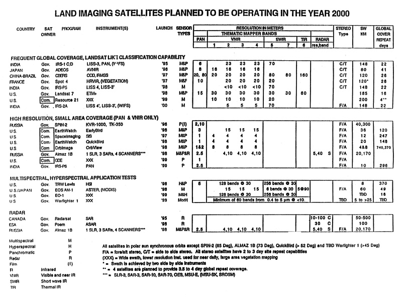
FUTURE SENSOR AVAILABAILITY
- Spot 3-4
- IRS-P2,1B
- ERS-1,2
- Priroda-mom2
- Lewis
- Clark
- Early Bird
- CRSS
- ASTROVISION
- EXEGLASS
- SEASTAR
- ADEOS
- RADARSAT
CRITICAL ISSUES
-Coverage frequency and timeliness
-Spatial resolution
-Sensor calibration
-Atmospheric Correction