
| Mississippi Basin Carbon Project Science Plan |
|
The Mississippi River is the largest North American river. Its basin (an area of 3.3 x 10⁶ km2) encompasses a remarkable range of variety in climate, vegetation, land use, and agriculture. The basin is well studied and includes areas that typify vast regions of the Earth’s surface that have undergone human development. By examining a variety of spatial scales, including the whole basin, we anticipate identifying those aspects of environmental change that have particularly large effects on carbon, nutrient, and sediment cycles. By exploiting the dense network of USGS stream gages, the availability of complete Geographic Information System (GIS) and Digital Elevation Model (DEM) coverage, and the large extant data bases assembled by the USGS and other Federal and state agencies, we are uniquely able to study the relationships affecting carbon in soils and terrestrial sediments over a globally significant region.
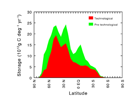 Figure 1 Latitudinal distribution of terrestrial sedimentary carbon sinks, showing both pre-technological sinks and those attributed to human land use. Calculated by Stallard (in press) for a single scenario in which enhanced carbon burial totals approximately 1 x 10¹⁵ g C yr-1 (or 1 x 10⁹ tonnes C yr-1). |
Based on the background information discussed above, we hypothesize that the rate of carbon burial in terrestrial depositional environments is enhanced by human activities. We suggest that accelerated erosion and deposition are accompanied by enhanced formation of soil organic matter on fresh substrates, including cultivated soils; and that the addition of nutrients from fertilizers, municipal wastes, and atmospheric deposition also contributes to the acceleration of carbon removal from the atmosphere and accumulation in terrestrial soils and sediments. We will pursue these ideas by investigating two core hypotheses:
Our consideration of these hypotheses is directed toward determining estimates of carbon fluxes that can be related to the global carbon budget. Our approach is guided by the fact that the present-day global carbon budget — including the problem of the global CO2 budget imbalance — is inherently historical. Although present-day industrial CO2 emissions and atmospheric CO2 increases can be documented on an annual basis, the other major terms in the annual CO2 budget (the terms for ocean uptake and effects of human land use) necessarily require historical information. These terms cannot be measured directly because they represent small net differences between large and uncertain "natural" carbon sources and sinks that have been perturbed by human activities. Estimates of these differences are derived from modeling the time-dependent effects of human influences. Estimates of annual ocean uptake (e.g., Siegenthaler and Sarmiento, 1993) are derived from time-dependent model calculations of oceanic CO2 dissolution and mixing for the period of historically increasing atmospheric CO2 concentrations. Likewise, calculation of annual land-use effects (e.g., Houghton and others, 1987) is based on time-dependent integration of historical sequences of carbon sources and sinks associated with areas of disturbance and recovery.
In a directly analogous manner, a historical approach is required to document the importance of terrestrial erosion, sedimentation, and soil development to the annual carbon budget. This approach emphasizes the application of time-dependent models rather than direct determination of large-scale annual fluxes. These models must make judicious use of available data and must be developed from careful field study of the processes that control the effects of human activities on the allocation of carbon in soils and sediments. Accordingly, our studies require the integration of modeling with extensive data analysis and field observations.
It is beyond our capabilities to account for all terrestrial carbon reservoirs and fluxes in the Mississippi basin. We will develop estimates of the amount of carbon stored in soils and sediments. We will model the historical evolution of that amount through time and, in so doing, we will calculate fluxes. Although we recognize that the Mississippi basin cannot be extrapolated to the world, we believe that the basin is diverse enough to provide a basis for estimating effects of human activities over broad areas of the northern hemisphere. These calculations will be directly relevant to global carbon budget estimates, but great care will be required in applying our work to specific carbon budget contexts. One such context is the "missing" terrestrial carbon sink that has been inferred from the imbalance among global CO2 budget terms. Some of these terms, particularly those relating to forests and soils, have varied in both definition and magnitude in recent studies (compare, for example, the CO2 budget summaries on p. 13 of IPCC, 1990, and p. 79 of IPCC, 1996). Application of our calculations to this budget context will demand very specific comparison to the treatment of soil carbon in budget terms defined elsewhere. Although previous treatments have not explicitly included significant carbon fluxes associated with erosion and deposition on land, some of these fluxes may have been encompassed implicitly in existing budget terms which include estimates of soil organic carbon depletion and recovery. Our contribution in this context will be to distinguish carbon fluxes representing net atmospheric exchange from those associated with erosion and sediment transport. This effort will require a careful, geographically explicit comparison of our own calculations with existing budget estimates. And because the unknown terrestrial sink is calculated as a residual of inherently historical terms, any attempt to identify it must incorporate documentation of its historical as well as present-day behavior.
Two time scales of particular importance to understanding the terrestrial carbon cycle in the Mississippi basin are (1) the period of widespread historical human influence (roughly, the last 200 years) and (2) the period of the most recent transition from glacial to interglacial climatic conditions (about 5,000 to 15,000 years ago). From the ice-core record of historical atmospheric CO2 concentrations, we know that changes in the land surface must have influenced atmospheric chemistry well before the Industrial Revolution (Neftel and others, 1985). An understanding of these historical changes is critical to understanding both the effects of early human land use and the nature of the carbon cycle before more pronounced human disturbance. Likewise, the most recent deglaciation was accompanied by conspicuous but poorly understood changes in terrestrial carbon cycling (Harden and others, 1992; Sundquist, 1993). An understanding of these deglacial changes will provide information needed to anticipate effects of potential future climate change. Together, studies of deglacial and historical changes will address the very important question of whether the carbon cycle was at a steady state prior to human influence. Model projections of future atmospheric CO2 concentrations are all based on the assumption of a prior steady state. Although this assumption is probably reasonable for short-term forecasts, it must be more carefully evaluated when applied to long-term simulations of effects of erosion, deposition, and soil carbon formation. Our focus on these processes requires consideration of time scales longer than those usually considered in forecasting anthropogenic CO2 perturbations.
The MBCP integrates simultaneous studies at three spatial scales which we define as the field scale, the sub-basin scale, and the whole-basin scale.
At the field scale, our focus is to identify and understand key processes. Current carbon budget calculations for changes in land use do not include explicit treatment of terrestrial sedimentation and erosion. Although the calculations may implicitly reflect partial effects of these processes, estimating their contribution to the CO2 budget imbalance is extremely difficult. Likewise, current models of carbon cycling in forests and soils cannot easily accommodate transport of carbon across the land surface. Because such models must be used to reconstruct past changes, and ultimately to anticipate effects of future human activities, they must be based on a thorough understanding of all the processes that control carbon cycling on the land surface. Empirical, non-mechanistic models, even though they may accurately resolve the present-day carbon budgets, may not be capable of forecasting the future magnitude of the Northern Hemisphere terrestrial sink.
Process-based models will require site-specific verification of the importance of enhanced erosion and sedimentation to soil development and other forms of terrestrial carbon accumulation. Fortunately, some of the most important questions concerning these processes are accessible to study at the hillslope and small watershed scale of typical field studies. For example, how much eroded soil and carbon are redeposited locally? How does cultivation affect the accumulation of carbon in soils? What is the stability of soil-derived carbon in alluvium and colluvium? What features of the land surface – both disturbed and undisturbed – control rates of carbon accumulation? Questions such as these can be studied by careful monitoring and sampling of hillslope transects, small basins, and chronosequences. Other questions, such as those concerning the relative importance of soil-derived and aquatic sources of carbon in sediments, can be addressed by analysis of sediment cores taken from lakes, reservoirs, and wetlands. A variety of chemical, isotopic, and monitoring techniques are available to help us to answer these questions.
Intensive field studies can only assess a small fraction of the basin area. Applying field process studies to larger spatial scales is not simply a matter of summation of results from the field scale. Results of these studies must be integrated with a wide range of data that are more readily applied to larger areas: GIS, DEM, inventories of dams and reservoirs, records of land use and land cover, fluvial discharge records, and soil and climate databases. Application of these data to basin-wide carbon budgets requires the extensive use of models. Modeling is inherent in every aspect of the MBCP. From the examination of site-specific processes to the integration of basin-wide information, modeling serves a wide variety of purposes. It is used as a teaching and learning tool by researchers during the course of ongoing investigation and hypothesis-testing. It is used for diagnostic purposes in analysis and synthesis of data and interrelationships. It serves prognostic needs for projection of trends (present, past, or future) that cannot be directly measured. Finally, modeling can provide the critical connections between our work in the Mississippi basin and that of the larger research community engaged in studies of carbon cycling and environmental change at the global scale.
We are prototyping this integration of data and models in the sub-basins of the Yazoo, Nishnabotna, and South Platte Rivers. Another prototype study is sited on the coastal plain and delta in Louisiana, and additional sites will be selected to extend our set of prototype basins across both north-south and east-west gradients in the basin. A primary advantage of such prototyping is that the integration design can be checked by detailed examination of data and field sites. Integration over the whole basin, while more important to the global carbon budget, must be based on methods and assumptions that are best evaluated at smaller scales. To assure that our work is always guided by the need to extrapolate beyond the field and sub-basin scales, we include whole-basin analyses even in the early stages of the project. Building on the analysis of sediment storage in the conterminous United States by Meade and others (1990), Stallard (in press) has developed a preliminary global synthesis of sediment and carbon storage by reservoirs, lakes, alluviation, and colluviation. These estimates provide an initial guide to estimating values for the Mississippi Basin as a whole. Upon completion of the project, our synthesis of data and models will include basin-wide maps of sediment and carbon erosion and storage, chemical weathering yields, and nutrient loadings. These maps, when integrated over area using GIS techniques, will provide a direct test of the working hypothesis that sedimentation on land is storing significant quantities of carbon. Effects of this carbon storage on the atmospheric CO2 budget can be estimated only by time-dependent modeling. GIS techniques can be used to simulate a range of plausible historical changes in the geographical distribution of basin properties. The combining of these GIS scenarios with time-dependent models will provide a test of the hypothesis that buried carbon is being replaced by new carbon fixation.
To the maximum extent possible, we will make use of existing land-surface models of sediment transport, erosion, and soil development. Likewise, existing carbon-cycle and ecological models will be exploited. However, these disparate land-surface, ecological, and carbon-cycle models are very difficult to link in a manner appropriate to our study. For example, models depicting carbon-cycle effects of human land use are often based on ecological land-surface classification schemes that ignore geomorphologic features that might control erosion and sedimentation. Soil development models must be adapted to accommodate erosion and sediment transport. Erosion models and sedimentation models must be linked together in a consistent manner that accommodates carbon transport and burial. Models of basin- or regional-scale processes must be linked to the global-scale carbon budget. Models of present-day processes must be linked to time-dependent simulations of historical trends. Therefore our efforts must emphasize integration across spatial and temporal scales and among various disciplinary perspectives. At the site-specific scale, we will examine ways to adapt soil development models to incorporate sediment and carbon transport to and from the site. At the basin scale, we will develop links between models of sediment transport and models of carbon transport. We will work with ecologists and land-use specialists to adapt models of historical land use to accommodate effects on erosion and carbon transport across the land surface. To test hypothesized implications of our work for the global carbon budget, we will implement a global carbon-cycle model linking terrestrial and marine carbon fluxes and reservoirs. The nature of the carbon budget problem requires us to encompass spatial scales ranging from site-specific to global, and temporal scales ranging from single floods to millennia.
The central concept essential to this degree of integration among diverse data and models is conservation of mass. This requirement is obviously inherent in our goal of defining carbon budgets, and would seem to be inherent in any model of material transport and transformation. However, the specific nature of our requirement is not fulfilled in existing models, many of which were developed for purposes that did not require mass balance in the sense needed for our studies. For example, models of soil erosion generally do not account for removal of material in both dissolved and particulate form, and do not incorporate sediment deposition. Models of sediment deposition often ignore colluvial deposition, and models of carbon transformation in sediments do not address sediments subject to repeated episodes of flooding and emergence. Models of soil development usually do not include erosive loss or depositional gain of material. To adapt and integrate these models and their concepts for our purposes, it is critical that we extend the requirement for conservation of mass across the landscape and through time.
| Contents | |
| Background | |
| Available data |