
| Mississippi Basin Carbon Project Science Plan |
|
Identification and field study of key processes
Site-specific, process-related studies are an essential component of the MBCP because we hypothesize that some important processes have been overlooked in the assessment of terrestrial carbon cycling. Objectives of our field studies include (1) identification of the major accumulation, decomposition, transport, and denudation processes for soil, sediment, and carbon; (2) identification of key processes that may be of critical value in extrapolating to basin and global scales, (3) field testing of the hypothesis that the deposition of carbon in lowland soils and sediments is enhanced by human acceleration of erosion and modifications of hydrologic systems and nutrient supplies; and (4) field testing of the hypothesis that soil organic carbon eroded from uplands is being replaced by accumulation of new organic carbon at rates sufficient to maintain significant soil organic carbon storage. The project will require integration of field data with many types of models and data characterizing the land surface at a variety of spatial and temporal scales.
The inherently historical calculations required to analyze the carbon budget, the time scales of soil disturbance and redistribution, and the time-integrating character of the soil and sediment record, require that our focus be on carbon in organic matter that resists decomposition for at least several years. SOC has been variously characterized as a mixture of labile (very young; mineralized within a year after deposition), intermediate (older; mineralized on time scales of years to decades), and nearly passive (old; mineralized over centuries or longer) pools of carbon (e.g., O’Brien, 1984; Gregorich and others, 1996; Parton and others, 1993; Trumbore and others, 1990; van Veen and Paul, 1981). Our focus emphasizes the need to understand controls on and responses of the intermediate SOC pool, which has been shown to comprise a large fraction of SOC in the upper horizons of a wide range of soil types (Trumbore and others, 1996, and references therein). This pool, however, cannot be extracted or measured directly. Its size and turnover can only be assessed indirectly by a combination of fractionation and isotopic techniques (e.g., Trumbore and others, 1996) We will apply these techniques to an understanding of the dynamic behavior of the intermediate SOC pool at our field sites.
Given this focus, our field studies will be guided by the principal terms in an idealized mass-balance equation for the intermediate SOC pool in soils or sediments:
| dC/dt = I - L = Iprod + Ideposit - Ldecomp - Lfire- Leros - Ldoc | (1) |
where dC/dt is the rate of change of soil or sediment intermediate SOC content, I is total input of intermediate SOC per unit time, L is total loss of intermediate SOC per unit time, Iprod is input by new production, Ideposit is input by sedimentation, Ldecomp is loss due to decomposition, Lfire is loss due to fire, Leros is loss by erosion, and Ldoc is loss by transport of dissolved organic carbon.
Iprod values for the intermediate SOC pool cannot be derived simply from estimates of net primary production (NPP), crop residue yield, or other measures of vegetative production, most of which mineralizes rapidly. We will infer estimates by a variety of indirect means, including studies of post-harvest crop residues (Buyanovsky and Wagner, 1986; Gregorich and others, 1996) and comparisons between relatively undisturbed soils and cultivated soils with known land-use histories (e.g., Harden and others, submitted). We will emphasize studies of the carbon isotopic composition of SOC, including the use of radiocarbon measurements (e.g., Trumbore and others, 1990) and the exploitation of isotopic shifts associated with cultivation (e.g., Harrison and others, 1995; Gregorich and others, 1996). Wherever possible, we will use recent (0 to 200 yr) soil chronosequences where the upper soil horizons are well characterized (e.g., Harden and others, submitted). All of these indirect methods will rely extensively on the application of soil carbon models such as CENTURY (Parton and others, 1993; Schimel and others, 1994; see below), which can be linked to models of vegetative production such as CERES-Maize (Jones and Kiniry, 1986).
Ideposit values can be obtained from studies of organic carbon movement along erosion-to-deposition pathways and from inventories of organic carbon in floodplain, terrace, alluvial, colluvial, lake and reservoir sediments. Because much of the sediment eroded from soils may be redeposited locally, our field studies will include mass balance calculations from elevation, soil, and sedimentation surveys in small drainage and plot experiments such as those conducted at USDA-ARS stations (e.g., Liu and others, 1997; McGregor and others, 1969). Other field studies will focus on carbon deposition on floodplains and in wetlands, lakes, and reservoirs.
Ldecomp estimates can be derived using a variety of analytical and sampling techniques, including chronosequences of recent deposits (Harden and others, submitted) and comparison of recently (1960-1980) archived soil samples to newly sampled soil profiles (Trumbore and others, 1990). Where these methods are not feasible in areas of intensive land disturbance, estimation of Ldecomp for the intermediate SOC pools will require alternative techniques, including soil-gas flux measurements in combination with 13C and 14C analyses of respired CO2 (Townsend and others, 1995), and comparison of pairs of older archived (1950's or older) and newly sampled soil profiles for estimation of the amounts of nearly passive pools of SOC (Trumbore and others, 1996). Incubation experiments will also be conducted to estimate intermediate SOC decomposition rates.
Estimates of Lfire require values for fire frequency and effectiveness of burn, and can be derived from historic and tree-ring records.
The Leros and Ideposit terms contribute to a sediment mass balance that requires quantification of the masses of soil eroded and redeposited on the landscape, and of the relation of the intermediate SOC pool to the mobile soil mass. Field study of these terms will require the careful selection of soil catenas (transects across hillslope gradients) where we can evaluate the mass and volume of mobile soil. We will need to account for the spatial relations of soil as it is redistributed on hillslope positions by transport. Initially, we may not be able to quantify the transport processes, although some estimates may be available from elevation remeasurement surveys and from ongoing erosion studies, such as those used in development of soil loss equations and in hillslope/watershed programs such as the Water Erosion Prediction Project (WEPP) (McGregor and others, 1969; Liu and others, 1997; Baffaut and others, 1997; Ascough and others, 1997; Nearing and others, 1989).
Ldoc values can be determined at the field scale by direct measurements of DOC in runoff and in soil water leaching out of the rooting zone. There are a number of uncertainties associated with such measurements related to stability of the organic fractions sampled and the large degree of spatial variation in soil water chemistry.
A variety of field and laboratory methods will be deployed to characterize organic carbon in soils and sediments, and to elucidate the factors that control carbon transfer to and from the intermediate SOC pool. These methods will vary depending on the environment under study. Field methods for our upland soil studies will include (1) excavation of soil profiles; (2) soil gas flux measurement and soil gas sampling for isotopic measurements to assess decomposition of the intermediate SOC pool; (3) monitoring of soil temperature and moisture; and (4) measurement of sediment transport and deposition. Laboratory methods will include (1) SOC fractionation procedures (Parton and others, 1993; Trumbore and others, 1990; Wander and Traina, 1996); (2) incubation studies (for example Fyles and McGill, 1986) to test decomposition rates defined by field respiration and carbon fractionation procedures; (3) carbon and nutrient chemistry of bulk soil and of soil fractions; (4) isotope chemistry (Townsend and others, 1995; Trumbore and others, 1990; Balesdent and others, 1987) on selected samples; (5) particle size and inorganic geochemistry on selected samples, and (6) bulk density on every soil horizon.
Sediments on floodplains -- including marshes, swamps, rice paddies and peat bogs -- differ in many ways from typical soils. Sediments from these environments will be sampled for total organic carbon, isotopic (137Cs, 14C, 13C), and microfossil (pollen and phytolith) analyses. These analyses will be used to establish variations in carbon accumulation through time, and to distinguish among different sources of carbon accumulation in each environment.
Techniques employed for study of lake and reservoir sediments differ somewhat from those used in upland soil or marsh/swamp environments. Although lakes do not contribute significantly to the terrestrial sediment carbon budget, we will use studies of lake sediments to infer environmental effects on the carbon budget of the surrounding land surface, and to test methods that will be applied to reservoir sediments. Lakes in Wisconsin, Minnesota, and the Dakotas have a wide range of chemical (acid to alkaline), biological (oligotrophic to eutrophic) and physical (open and closed basin) attributes; therefore, they are ideal localities to compare and contrast effects of anthropogenic and natural environmental/climatic change on sediment records of carbon cycling. Sediments will be analyzed for bulk chemistry (including organic and inorganic carbon content), age determination by radionuclide analyses (210Pb and 137Cs), and stable isotope ratios in a number of constituents. Through these analyses we intend to relate changes in land use and environmental conditions to rates of organic carbon accumulation. Our studies will focus initially on oligotrophic and eutrophic settings of acid and alkaline lakes in northern and southern Wisconsin. This comparative approach will increase our understanding of how land-use and other environmental changes have affected the accumulation and cycling of carbon. Initial results suggest that recent trends in carbon accumulation, bulk isotopic characteristics, and onset of varve sedimentation correspond temporally to documented changes in environmental conditions (i.e., land use, cultural eutrophication, anoxia) and climatic fluctuations (i.e. duration of lake ice cover, temperature, amount of rainfall, atmospheric circulation patterns, etc.). Data from sediments collected in Minnesota lakes indicate past changes in hydrologic regime (open to closed basin) and migration of the forest/prairie boundary. Our ongoing experience in studying lake sediments will be applied to studies in reservoirs, where more significant amounts of carbon may be buried as a result of human activities.
We will use measurements of the isotope 10Be to provide indices of the state of soils with respect to erosion and deposition. 10Be enters the soil from the atmosphere in rainfall. It is particle-reactive and is adsorbed most strongly by the inorganic fine fraction, particularly manganese and iron-oxyhydroxide complexes. 10Be varies vertically in pedons, with the highest concentrations in the Bt horizons. In a minimally eroded soil developed in Peoria loess (a common substrate in the north-central part of the Mississippi basin and along the Mississippi River as far south as Louisiana), we can expect the depth-profile of 10Be concentrations to mimic the clay distribution. Redeposition of eroded soil, particularly the clay fraction, can be correlated with 10Be concentration of sediments (Valette-Silver and others, 1986; Brown and others, 1988; Pavich and others, 1993). In a small basin, it may be possible to construct a mass balance of the 10Be removed from eroded sites and redeposited at accretionary sites downslope. In part, the success of this approach will depend upon our ability to accurately measure soil accretion in field characterization of pedons. Trimble (1975) presented methods for estimating the volumetric changes associated with soil redistribution on an erosional landscape. To complete the mass balance in a small basin, we will need accurate measurements of volume and bulk density changes during soil erosion, as well as an estimate of the soil exported from the basin.
Soil catenas will provide contrasting sites for 10Be analysis. To simplify the calculation of mass balance estimates, each catena must have a uniform parent material. The Peoria loess has been analyzed at several Mississippi basin sites for 10Be. The analyses show that there is a background of inherited 10Be on the unweathered, carbonate-rich loess. Typically the background concentration is significantly less than the concentrations measured in soil horizons. On a uniform parent material, a relatively simple model of 10Be mass balance can be constructed. The mass balance in atom cm-2 for any pedon in the catena can be expressed by the equation:
| 10Betotal = 10Beinh + 10Beatm - 10Beerode + 10Beaccrt | (2) |
where: 10Beinh is the background inventory of 10Be (inherited from the previous history of silt and clay particles now in the loess); 10Beatm is the cumulative deposition from the atmosphere at the site; 10Beerode is the cumulative erosional loss on particles removed from the top of the pedon; and 10Beaccrt is the cumulative amount accreted in the pedon on particles transported from upslope. In the case of a soil that has not been altered by erosion or accretion since the end of Peoria loess deposition (ca. 12ka), the total should equal the inherited amount plus the cumulative atmospheric deposition. The catena must contain at least one site which represents the pre-agricultural, uneroded soil to serve as a control for comparison of eroded and accreted sites. In such a pedon, we can determine the vertical sequence of horizon boundaries, bulk densities, texture, bulk chemistry, carbon chemistry, and isotope chemistry.
The use of 10Be to identify eroded or aggraded soil in the catena will depend upon our ability to identify and sample soil horizons. The 10Be concentration distribution in a disturbed profile may be distinctly different from the distribution in the uneroded control site. Concentration variations may help us to identify the thickness of soil eroded or aggraded relative to the control site. Bulk density measurements will also enable us to calculate the inventories (atom cm-2) of 10Be in eroded, aggraded, and control sites. Once we have an understanding of the vertical dimensions of erosion and aggradation, sampling can be simplified to obtain inventories from cores of pedons, significantly reducing the number of 10Be analyses. Future studies may augment these analyses using measurement of 137Cs and 7Be.
Criteria for field site selection will be a critical aspect of this research. Ideally, the number of detailed study sites would be sufficient to characterize the major processes controlling carbon cycling. However, the resources of the MBCP are not sufficient to assess carbon dynamics in all the major environments of the Mississippi basin. Study sites will therefore be distributed to enable us to characterize processes of carbon accumulation at typical and extreme values along a climatic continuum. Within those sites we will evaluate factors in the carbon mass balance (equation 1) along slope transects or catenas (Schimel and others,1985) that represent major soil mapping units of the area. Wherever possible, study sites will include existing relevant databases such as soil and sediment records and historic records of land use practices, as well as ongoing erosion/runoff studies, such as the runoff plots of the Agricultural Research Service (ARS) and sites included in the WEPP (Ascough and others, 1997; Nearing and others, 1989). Another important criterion for site preference will be the availability of archived soil samples. To the maximum extent possible, we will locate field study sites in the sub-basins selected as prototypes for the MBCP. Figure 2 shows the locations of selected and potential field sites and sub-basins.
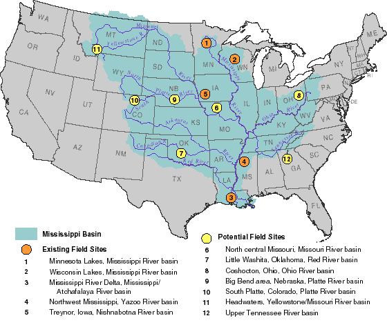 Figure 2 Map showing the Mississippi River Basin and existing and potential MBCP field sites. |
| Contents | |
| Land surface characterization and analysis | |
| Modeling landscape mass balance |