In addition to the figures viewable directly from the text, the CD-ROM contains a directory called maps. This directory contains files in Arc/INFO format and consists of the complete sidescan sonar mosaic, bathymetric data, Holocene-age sediment isopach map, Pleistocene structural map, ship tracklines, Puerto Rico coastline, and sediment sample locations and analysis information. All of the data are mapped in Universal Transverse Mercator projection (UTM), zone 20, with the Clarke 1866 reference ellipsoid.
![]() SIDECAN
SONAR
SIDECAN
SONAR
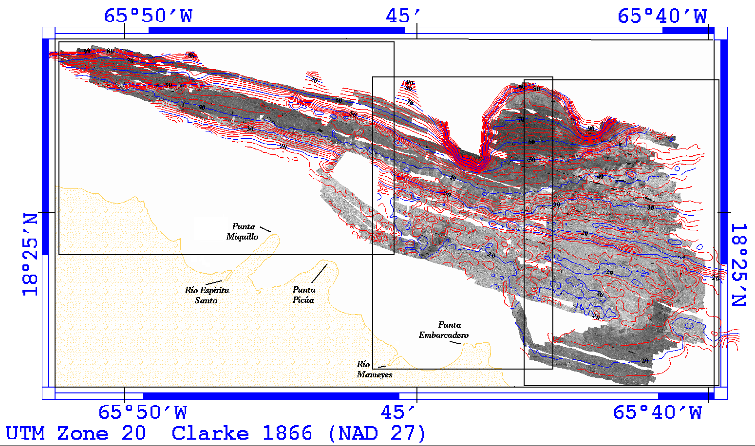
To register the sidescan mosaic for use within Arc/INFO, I first gridded (using Arc/INFO gridimage) the raster image generated by PCI. Then used gridwarp in Arc to register the image. The file whole.lnk is the file representing the corner points and the corresponding UTM coordinates of the original raster image. This link file is used by gridwarp to perform the georeferencing transformation of the raster image. The final gridded and registered product is in the directory maps/sidescan.
![]() BATHYMETRY
BATHYMETRY
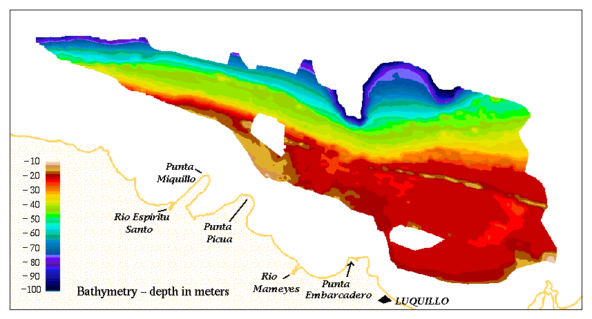
The bathymetric data were generated by digitizing existing contour maps (Schwab and others, 1996b). Two directories are associated with this data - one is a line coverage and the other a polygon coverage. Because of the density of the contours, a polygon coverage with a color coded depth relationship is generally easier to work with. Included with these data are a file called bathy.shd which is the Arc/INFO shadeset used for the image displayed here (polygon coverage). The line coverage has an attribute called linetype. By using the included symbolset contours.lin with this attribute, the contours will be displayed with the appropriate dashes and hachures. The screen display is white lines, but prints as black.
![]() PLEISTOCENE
STRUCTURE CONTOURS
PLEISTOCENE
STRUCTURE CONTOURS
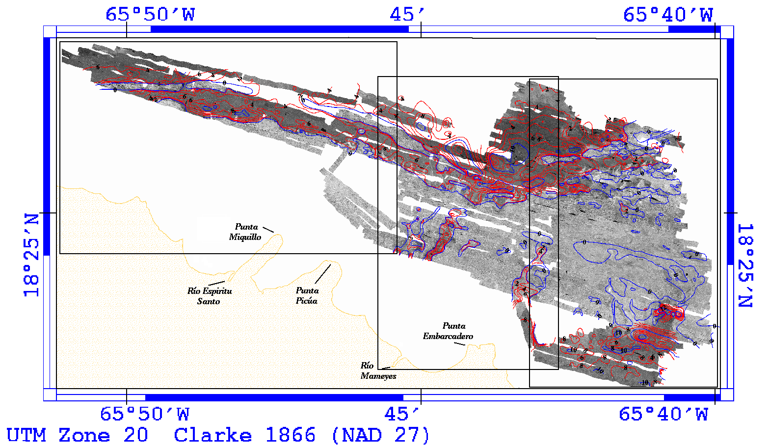
As with the bathymetric data, this data was generated by digitizing existing contour maps(Schwab and others, 1996b). There are also 2 coverages, the line coverage and the polygon coverage. By using the included shadeset bathy.shd, the same color range as the bathymetric data is displayed. The line coverage also has an attribute called linetype and can be treated the same way as the bathymetric data.
![]() HOLOCENE-AGE
SEDIMENT THICKNESS
HOLOCENE-AGE
SEDIMENT THICKNESS
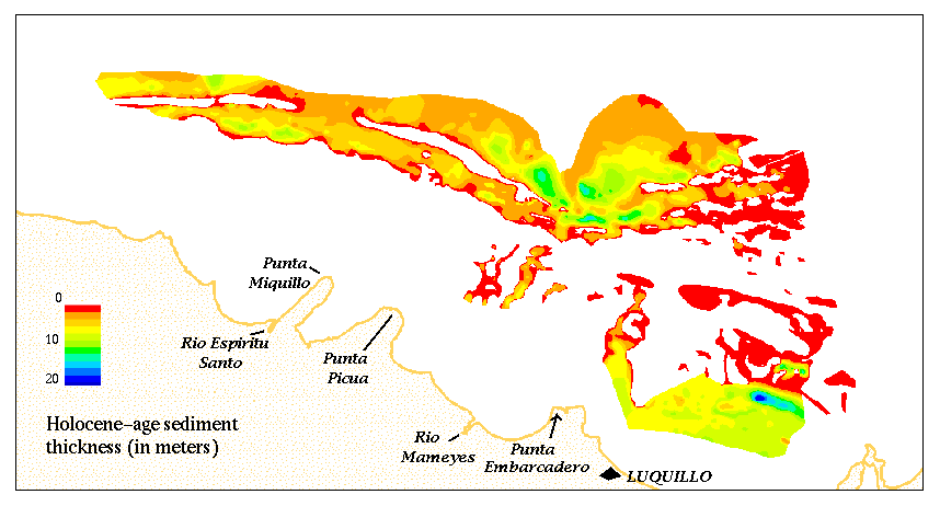
This isopach data was generated by digitizing existing contour maps (Schwab and others, 1996b) and has a line coverage and attribute linetype so that it can be treated in the same manner as the bathymetric and Pleistocene datasets. However, for the polygon coverage, the Arc/INFO shadeset file isopach.shd (included on the CD-ROM) is more appropriate.
![]() SEDIMENT
SAMPLES
SEDIMENT
SAMPLES
Sediment samples contained in this dataset are only those collected offshore. Samples have a number preceded by either "Bor" or "GS". The numbers proceded by "Bor" indicate samples collected in 1992 aboard the RV Boriken; numbers proceded by "GS" indicate samples collected in 1991 aboard the RV Jean A; and numbers followed by "A" or "B" indicate duplicate analyses. The sed-code attribute simply assigns a number to each of the classifications given. These values are as follows:
![]() Sed-code 1 ----- clayey_silt
Sed-code 1 ----- clayey_silt
![]() Sed-code 2 ----- sand_silt_clay
Sed-code 2 ----- sand_silt_clay
![]() Sed-code 3 ----- sandy_silt
Sed-code 3 ----- sandy_silt
![]() Sed-code 4 ----- silty_sand
Sed-code 4 ----- silty_sand
![]() Sed-code 5 ----- sand
Sed-code 5 ----- sand
![]() Sed-code 6 ----- gravel>10%
Sed-code 6 ----- gravel>10%
![]() Sed-code 7 ----- silt
Sed-code 7 ----- silt
![]() TRACKLINES
TRACKLINES
The tracklines were derived from the sidescan sonar navigation at 1 minute intervals.
![]() COASTLINE
COASTLINE
The Puerto Rico coastline was digitized at 1:100,000 from the following NOS charts - #25641, 25677, 25671, and 25668.
[an error occurred while processing this directive]