interpretive_map.pdf

backscatter_map.pdf
sunilluminated_map.pdf
Massachusetts Bay Disposal Site Map Gallery
Instructions: To view the individual maps below in pdf format, you should open them up in Adobe Acrobat Reader outside of your web browser. Opening up the maps within the browser may slow down the processing time. Click here to download Adobe Acrobat Reader if you do not already have it installed. Then start the reader from your desktop and select the map file from the pdf directory on the CD. The file names are indicated under the images below. You may need to center the image in the reader once you have opened it. Just click on the page-centering tool in the toolbar, and the image will come into view. For an explanation of map features, go to Discussion of Seabed Features.
|
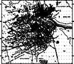
INTERACTIVE Map showing interpretation of disposal site features, including locations of sample stations and video tracklines. Different types of disposed materials are represented by different symbols and patterns. The map is in a Mercator projection at a scale of 1: 10,000. This map is also available for downloading in Encapsulated PostSript (.eps) and Postscript (.ps) formats. The page size of the printed map is 30" x 26.75". The key for this map is also available for downloading in Encapsulated PostScript and PostScript formats. |
|
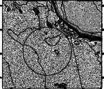
Map showing sea floor backscatter. This map shows the bottom types of the disposal region. In this image, the high backscatter is indicated by the light areas and the low backscatter is indicated by the dark areas. High backscatter represents a hard bottom, such as sand and gravel, whereas the low backscatter is indicative of soft bottom, such as mud. The map is in a Mercator projection at a scale of 1:12,500. This map is also available for downloading in Encapsulated Postscript (.eps) and Postscript (.ps) formats. The page size of the printed map is 23.75" x 21.5". This imagery is also available in a tiff format without the contours. You will need to download the associated world file to georeference the image for use in a GIS. |
|
Map showing sun-illuminated topography. This map shows the topographic contours of the disposal site region in 5 meter intervals with the sun-illuminated image in the background. The map is in a Mercator projection at a scale of 1:12,500. The image is illuminated from the north, and has a vertical exaggeration of 4. This map is also available for downloading in Encapsulated Postscript (.eps) and PostScript (.ps) formats. The page size of the printed map is 23.75" x 21.5". This imagery is also available in a tiff format without the contours. You will need to download the associated world file to georeference the image for use in a GIS. |
Return to Introduction
and Table of Contents
[an error occurred while processing this directive]