Alaska Division of Geological & Geophysical Surveys
794 University Avenue, Suite 200
Fairbanks, AK 99709
Telephone: (907) 451-5006
Fax: (907) 451-5050
e-mail: gail@dnr.state.ak.us
URL: http://wwwdggs.dnr.state.ak.us
More than 15 years ago, the Alaska Division of Geological and Geophysical Surveys (DGGS) acquired a minicomputer to assist in geochemical modeling. Included with the modeling software was a GIS system. Over the next several years, use of the GIS system grew, while use of the modeling software stagnated. We first used the GIS to locate geochemical sample locations and attach analytical data to them, then ran various statistical programs outside the GIS and used the results to produce maps of geochemical anomalies. Concurrently we began to digitize geologic contacts and produce black and white maps that were as similar as possible to maps made by older cartographic methods. One staff member, supplemented by student interns, was involved in the GIS effort. The remainder of the DGGS staff, 150 strong at the time, showed little interest in the possibilities for the new method.
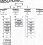
The present DGGS staff of 25 is illustrated in Figure 1. At this time, DGGS uses Arc/Info to produce all of its geologic maps. These maps are made to resemble as closely as possible the maps formerly made by hand. The GIS is being used as a cartographic output system with the added advantage of easier updates. In the past, project geologists have passed their completed geologic work to a Publications Section to put it into publishable form. With so few staff members in the Survey, we no longer have that luxury.
Under the present scheme, project teams include a cartographer, the editor, and the GIS manager as well as field mappers and student interns. Few of the geologists have used the GIS system to date. Only one of the cartographers is GIS-literate. In theory, projects are responsible for their own GIS work from start to finish. The GIS manager and the cartographer are teaching student interns to digitize and edit maps, then to make final output copy. Unfortunately, students are transitive, and several months worth of training time is often used for only one project, then we start over with training a new student. Project geologists are complaining that the GIS is too hard to learn, that they don't have time to do this work on top of everything else, and that we need more cartographers to do this work for them. GIS work is seen as mundane digitizing only. There is little knowledge of what databases can do for data analysis, or of what projects can contribute to a growing spatial database. Although we are adding new types of data with each project, there is a very little geospatial analysis being done, barring a few derivative maps from surficial geology.
CLICK ON THUMBNAIL FOR FULL-SCALE IMAGE [126K] |
Figure 1. Organizational chart of the Alaska Division of Geological and Geophysical Surveys. |
Our dream for the future includes having the entire GIS database available to all geologists on their desktops for them to use in data analysis. We dream of a user-friendly interface with which geologists can pull together all types of data gathered in the field and from the literature to construct and improve the database of geologic mapping. We envision a relational database that is driven by the needs of geologists for the geographic component of the data. All the geologists and support staff of the Survey will have access to the data and be adding to it. The database will be the basis for creating maps and reports as well as publishing them. All of the geologists will be intimately involved in data entry and analysis. Most importantly, the growing database will be available to our customers, the public, over the World Wide Web.
How do we get there from here? How do we convince the geologic population that not only are databases important, but that their direct involvement with those databases is critical to the success of the agency?
So far we don't have answers for these questions. One obvious answer to the workload problem is to hire more staff to input data. This, however, is a funding problem in the present scenario of budget cuts, and it removes geologists from direct contact with the data. Partnering with other agencies is a popular concept, though in practice, geologists are reluctant to give up territory. As more talks at geological conferences emphasize a use of GIS databases to solve problems, the importance of the technology should grow.
U.S.Department of the Interior, U.S. Geological Survey
<https://pubs.usgs.gov/openfile/of98-487/davidson.html>
Maintained by Dave Soller
Last updated 10.06.98