Natural Resource Information Division
National Park Service
1201 Oak Ridge Drive, Suite 350
Fort Collins, CO 80525
Telephone: (970) 225-3559
Fax: (970) 225-3585
e-mail: Joe_Gregson@nps.gov
Bedrock and surficial geologic maps and information provide the foundation for studies of ground water, geomorphology, soils, and environmental hazards. Geologic maps describe the underlying physical habitat of many natural systems and are an integral component of the geophysical inventories stipulated by the National Park Service (NPS) in its Natural Resources Inventory and Monitoring Guideline (NPS-75). This summary outlines the cooperative endeavor among the NPS Geologic Resources Division (GRD), NPS Inventory and Monitoring (I&M) Program (Natural Resource Information Division - NRID), U.S. Geological Survey (USGS), and individual state geological surveys to implement a systematic, comprehensive inventory of the geologic resources for about 265 NPS units with significant natural resources. The on-going and proposed NPS Geologic Resources Inventory consists of three main phases: 1) a Geologic Resources Bibliography (GeoBib) of literature and maps, 2) an evaluation of existing, needed, and in-progress map coverage and subsequent production of digital products, and 3) a compilation of a geologic report with basic geologic information, hazards and issues, and existing data and studies. New geologic mapping projects may be initiated on case-by-case basis after careful evaluation of park needs, costs, potential cooperators, and funding sources.
In addition to the existing GeoBib database development and data management planning, GRD and I&M sponsored a Baseline Geologic Data Workshop in Denver in fall of 1997 to get input from NPS, USGS, and state survey personnel and cooperators about basic geologic data needs that could be provided by the I&M Program. At the Denver meeting, Colorado, Utah, and North Carolina were chosen as pilot project states to maximize the cooperation among NPS, USGS, and state surveys. In general, discussions and work have affirmed the existing three-phase approach illustrated in Figure 1.

Figure 1. The three themes of the geologic resources inventory process. |
The GeoBib project is completing the initial phase of data collection for existing geologic resources (maps and literature) in each NPS unit and publishing the data on the NRID Intranet. The bibliography is discussed in more detail in a later section. In addition, index maps of the location of associated geologic maps are being prepared for the parks in Colorado. When map coverage for each park is determined, map products can be evaluated, and potential mapping projects identified and initiated.
Pilot geologic issues/map scoping meetings (Park Teams) are being organized in 1998 to evaluate the resources in Colorado parks and will be followed by pilot projects in Utah and North Carolina in the next fiscal year. Park Teams will identify existing maps for digitizing or conversion to NPS standards. A separate task group is developing a geology-GIS standards document to ensure uniform data quantity and quality for digital geologic maps. A pilot digitization project for Craters of the Moon National Monument will provide additional input for the digital map standards. In addition to evaluating geologic maps for digitization, park scoping meetings will identify new geologic mapping needs. However, the high cost of geologic field mapping and thematic map digitization requires additional long-term planning and exploration of cost-effective programs and partnerships for new projects.
After completion of map inventories, a geologic report of USGS and state geological literature, park, and GRD data will complete the project for each park. The geologic report content, format, and database are being developed and are outlined in a later section.
The idealized NPS Level I Inventory goal of bedrock and surficial geologic maps for each park at 1:24,000 scale is compatible with similarly specified scales for base cartography, soils maps, and vegetation maps. However, acceptable geologic map scales must be determined by case-by-case evaluations of existing products, park needs, and mapping costs. USGS and state surveys are digitizing maps for on-going mapping projects, but scales vary and coverage of all NPS areas will probably never be digitized without in-house or contracted work by GRD and the I&M Program.
The GeoBib project is collecting individual park bibliographies and publishing the data on a secure intranet database system. USGS made bibliographic searches of the Georef and Geoindex databases for each park, which were converted to Procite data files. The Procite data must still be converted for the intranet system, map citations must be edited for duplicate entries, and a list document and index map of associated geologic maps must be prepared. The completed GeoBib database will contain about 100,000 citations of geologic resource literature in an on-line database.
With GRD and I&M funding, a Colorado State University student was hired to work on the GeoBib database. Bibliographies for 27 parks in the three pilot states were edited for duplicate map citations and used to compile a list of geologic maps for each park. Bibliographies for additional 15 western parks were converted and loaded into the database for editing. After removal of all duplicate map citations, geologic map citation lists will be prepared for each park and used to develop index maps of the footprint of associated geologic maps relative to park boundaries. The map lists and index maps will be converted to word processing documents for transfer to cooperators.
Several agencies are digitizing geologic maps with conventional methods as well as vectorization or heads-up digitizing of scanned images. The I&M task groups will evaluate these methods to allow versatile data acquisition. Scanning and vectorizing of geologic map masters will be tested in a pilot digitizing project of four geologic maps of Craters of the Moon National Monument by the Columbia Cascades Support Office GIS personnel. In addition, as part of this inventory, the I&M Program and GRD plan to obtain conventional digitizing technology and digitize select geologic maps in house. On-going and completed park mapping and digitizing projects will be tracked in the Dataset Catalog system on the NRID Intranet. Digital map products will be archived and distributed on CD-ROM.
The inventory report will contain summaries of the exploration history, geology, unique features, paleontology, disturbed lands issues, geologic data, geologic hazards, and other geology-related issues to describe the basic geologic resources of each park. Several report sections, such as stratigraphic columns and geologic cross section graphics, will incorporate available literature and will be developed with assistance from student employees. Other sections will summarize ongoing NPS programs such as disturbed lands and paleontological inventories. A database system is being developed for the NRID Intranet to provide on-line access for report development and dissemination. An expanded report outline is shown in Figure 2.
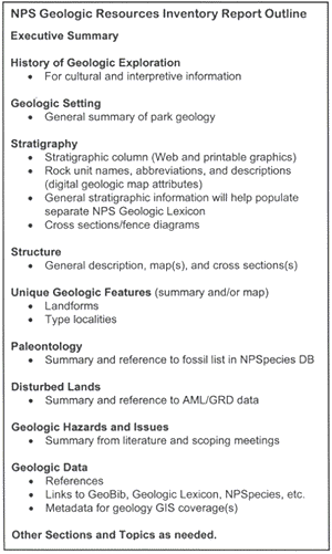
Figure 2. Outline of geologic report. |
In conclusion, the NPS Geologic Resources Inventory is being actively developed with the cooperation of USGS and state geological surveys. However, many opportunities for project collaboration and cooperation exist that have not yet been identified, and effective communication among existing and potential cooperators is a key factor for success of the inventory. Another challenge of inventory planning is the development of digital map standards that are adaptable to diverse geological conditions but still provide quality, uniform products and firm guidance for cooperators and workers. Indeed, the diversity of geologic resources found in the National Park System will provide a continuing challenge for effective project management.
The National Park Service has identified GIS and digital cartographic products as fundamental resource management tools, and the I&M Program and Geological Resources Division are developing an efficient inventory program to expedite the acquisition of digital geologic information for NPS units throughout the country.
U.S.Department of the Interior, U.S. Geological Survey
<https://pubs.usgs.gov/openfile/of98-487/gregson.html>
Maintained by Dave Soller
Last updated 10.06.98