1U.S. Geological Survey
908 National Center
Reston, VA 20192
Telephone: (703) 648-6907
Fax: (703) 648-6937
e-mail: drsoller@usgs.gov, sprice@usgs.gov
2Illinois State Geological Survey
615 E. Peabody Drive
Champaign, IL 61820
Telephone: (217) 244-2776
Fax: (217) 244-7004
e-mail: berg@geoserv.isgs.uiuc.edu
3Illinois State Geological Survey (retired)
507 Patlynn Drive
Fairhope, AL 36532
Telephone: (334) 928-7083
INTRODUCTION |
|||||
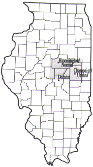
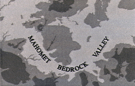
| A cooperative geologic mapping project was conducted by the Illinois State Geological Survey (ISGS) and the United States Geological Survey (USGS) to map the Quaternary deposits in east-central Illinois (Figure 1). This area provides an excellent geologic setting to develop and test new techniques for mapping Quaternary deposits in three dimensions (i.e., mapping the thickness and distribution of geologic materials both at land surface and in the subsurface), because it has diverse Quaternary geology and thick, regional sand and gravel aquifers within a buried bedrock valley system (the Mahomet Bedrock Valley). The Mahomet Sand, which fills the deepest portions of the bedrock valley, is the thickest and most widespread glacial aquifer in the system. In addition, overlying the Mahomet Sand are sand and gravel units intercalated with fine-grained deposits. Where the Mahomet Sand is absent, these aquifers are important sources of water for rural farmsteads, communities, and industries. Decades ago, this bedrock valley commonly had been considered part of the Teays River System, a proposed westward-flowing drainage system formed during preglacial and glacial times, which was thought to extend across Illinois, Indiana, and Ohio, to West Virginia; however, modern evidence suggests that the Mahomet Bedrock Valley is a local drainage system in western Indiana and eastern Illinois that formed during early glaciations through alteration of the preglacial drainage patterns (Kempton and others, 1991). |
|
||||
In past studies, various surface and subsurface mapping techniques have been applied to all or parts of the map area. These include an ISGS statewide stack-unit map (Berg and Kempton, 1988) which shows the succession of geologic materials in their order of occurrence to a depth of 50 feet and a small-scale (1:1,000,000) USGS map of thickness and character of Quaternary deposits (Soller, 1993 and in press). Detailed geographic information system (GIS) mapping techniques (Berg and Abert, 1994, and McLean and others, 1997) also were developed for the region.
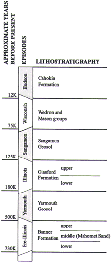
The total glacial drift succession is locally greater than 500 feet thick in the Mahomet Bedrock Valley, whereas the bedrock uplands are covered by 50 to 300 feet of glacial sediments (Figure 2). These deposits are a complex sequence of diamictons and sands and gravels associated with multiple glaciations and buried soils associated with interglaciations. [A diamicton is a mixture of clay, silt, sand, gravel, and boulders that, if of glacial origin, is commonly referred to as till; although most of the diamictons in the map area are interpreted as till, we use diamicton, the more general descriptor.] From top to bottom, the sediments are grouped into three major lithostratigraphic units (Figure 3): the interfingering Mason and Wedron Groups and overlying Cahokia Formation alluvium (Wisconsin and Hudson Episodes, respectively), the Glasford Formation (Illinois Episode), and the Banner Formation (pre-Illinois Episode). The Glasford and Banner Formations are, respectively, separated into two and three subunits. The middle Banner Formation subunit is mostly composed of the Mahomet Sand, and is confined to the area of the Mahomet Bedrock Valley, generally trending east-west across the map area, and to the Mackinaw Bedrock Valley to the west. For each of these major sedimentary units and subunits, elevation and thickness maps were developed at 1;250,000-scale for presentation at 1:500,000-scale, as described below. A perspective view of the top of the middle Banner Formation and of the bedrock surface is shown in Figure 4.
|
Figure 2. Thickness of glacial sediments, with minor, overlying sediment of non-glacial origin. Dark gray = sediment thickness is 0 to 150'; medium gray = 150 to 250'; light gray = more than 250'. Sediments overlie a bedrock surface of moderate relief; thicker sediments occur in the Mahomet Bedrock Valley and beneath Wedron Group moraines, and somewhat thinner sediments occur on the bedrock uplands. The Mahomet Bedrock Valley is a pre-glacial and early-glacial drainage system in the region (see Kempton and others, 1991). North is to top of map. |
|
|
Over many years, an extensive ISGS collection of records from wells and borings has been used to interpret age relationships and lithology for geologic mapping and groundwater studies in cooperation with local, State, and Federal partners. A cornerstone of our current effort was identifying a set of "key stratigraphic control points" (Kempton, 1990) from the ISGS collection of subsurface data. From these control points, we built a stratigraphic database. We identified 177 such borehole records, which is about 1.5 per township. These data served as principal control for constructing maps of each stratigraphic unit.
Because of the thick sequence of geologic materials in the region, and the paucity of exposures, subsurface information was a critical part of the geologic mapping project. Subsurface information formed the basis for most geologic maps of the region and for the evolution of concepts of the geologic history of the Mahomet Bedrock Valley system and the origin of the sediment cover that incrementally buried it (for example, Horberg, 1953; Kempton and others, 1991; Herzog and others, 1995; and Larson and others, 1997). It was a primary goal of our study to build upon the findings of prior investigations, using newly refined stratigraphic data to produce updated, revised maps that could be used for various computer-aided applications such as ground water modeling.
Another goal was to produce these maps using digital methods because counties, planning agencies, and other entities increasingly are using GIS to support decisionmaking and planning. Because computer-based mapping of deposits in three dimensions is not yet a common, well established practice, we developed GIS-based methods to integrate point (key stratigraphic control data) and areal (geologic mapping) data. These methods are only briefly described here, and will be detailed on a forthcoming USGS map (D.R. Soller, S.D. Price, R.C. Berg, and J.P. Kempton, unpublished data) and in a forthcoming publication.
Maps constructed using GIS techniques are in some ways easier to produce than conventional, hand-drawn maps. For example, map revision and generation of color proofs is done more quickly in a GIS. For other needs, however, conventional mapping can be easier and less time-consuming. For example, consider an area with thin, discontinuous units. While creating a hand-drawn set of maps showing elevation of the top of each unit, the geologist will attempt to ensure, visually, that a unit's elevation contour lines do not conflict with those of overlying and underlying units (for example, that the elevation of a lower unit does not surpass an upper unit). In so doing, the geologist produces an internally consistent, three-dimensional geologic model and set of maps for a region.
With GIS techniques, maps are produced that are similar in appearance to hand-drawn maps; to the eye, each elevation map may appear to not conflict with the elevation maps of other stratigraphic units. However, to develop a truly internally consistent set of maps, the maps are processed into a raster (gridded) format, as described below. Then, conflicts in elevation between horizons (and larger conflicts across several horizons) are easy to detect. Correcting those conflicts is not, however, a trivial undertaking. A significant effort was spent to develop a set of maps which adhered to our models for glacio-fluvial deposition and erosional history.
For each of six primary stratigraphic units and two minor sand layers, we created three products: a three-dimensional perspective view, an elevation map of the upper surface, and a thickness map. Our mapping of each unit was an iterative process that, through re-examination of stratigraphic data and maps, gradually refined our understanding of the vertical and lateral distribution of each unit. To map a unit, we first plotted the stratigraphic control data, then prepared a hand-contoured map based on the data and an understanding of the regional distribution of the materials and geologic history (for example, the middle Banner Formation had a glacio fluvial origin and was confined to bedrock valleys). The map was then scanned and a vector map of the linework was created.
A vector map generally is a faithful rendition of a hand-drawn contour map. For example, each vector, or line, on an elevation map of the upper surface of the middle Banner has an elevation value (for example, the 475' or 500' elevation contour). Areas between contour lines possess a range of elevation (for example, between 475' and 500'), and the elevation at any location on the map (other than on a contour line itself) cannot be more precisely defined. Although such values may be inferred by interpolation, they are not explicitly defined. A raster map, however, depicts information at each of many regularly spaced grid cells. It contains more information than a vector map, because it also provides an estimated or interpolated value between data points and contour lines. Computer-generated cross-sections, 3-D visualizations, and many modeling routines (for example, for ground-water flow) require raster data.
Data on the vector map was processed to a raster format. Although useful for analysis, raster maps can appear somewhat different from vector maps - they tend to show the map information with a blocky or jagged appearance rather than the smoothly drawn boundaries to which we are accustomed. For presentation, we considered creating a smoothed, vector version of each raster map. However, the time and expense involved and, more importantly, our desire to emphasize the analytic uses of digital geologic maps led us to retain the raster maps in this report. To aid visual aesthetics, we chose a small raster grid size (100 meters), thereby minimizing the characteristic blockiness of raster maps. If only the key stratigraphic control data were considered in the gridding, this grid size would be inappropriately small. However, for each unit a general interpretation of depositional and erosional history was developed (a conceptual geologic process model), providing a basis for assumptions about each unit's three-dimensional distribution. Our grid size was selected to maintain the traditional, vector-like appearance of the maps while creating a digital map product that could be adapted to more analytical purposes. For an application such as ground-water modeling, the grid cells may be aggregated to provide a spatial framework more realistic to the needs of that application.
After each elevation map was rasterized, it was compared to the stratigraphic control data and to the maps of units above and below it. This was the first stage of an iterative process of re evaluating stratigraphic interpretations in the database and refining the maps. In many cases, stratigraphic interpretations were difficult because units of distinctly different ages and different depths can look the same. For example, in a test boring that sampled multiple diamictons, upper Banner Formation diamictons can be misidentified as lower Glasford Formation, especially if intervening soils are not present. If, based on the regional geologic map trend, the elevation of a stratigraphic unit at a particular point was anomalously higher than appropriate, it was reexamined for a potentially better fit with an overlying map unit. In some cases, the lithologic characteristics of the sample were inconclusive and the stratigraphic interval was assigned to the younger age, whereas in other cases the stratigraphy was found to be correct and diagnostic of the lower unit. In the latter case, a shortcoming of the regional mapping is indicated; the anomalously high data point was correct and represented some local relief that was not mappable at our scale. Those map data were retained, and the resulting local "spike" in the map surface indicates a need to gather more information for that area.
Discontinuous units are particularly difficult to map because gridding algorithms compute cell values by interpolation methods. [We used the Arc/Info Topogrid algorithm; for these data, we found that other algorithms supplied in Arc/Info and other software (EarthVision) provided results of somewhat lesser quality.] No algorithm can produce a realistic map where data are absent across areas of relatively high relief. Consider, for example, the middle Banner Formation (Figure 4), which is confined to valleys separated by expanses of upland. A gridding algorithm must compute a value for every cell, including those far removed from data points, and each cell's value depends in some measure on adjacent cells. Unrealistic cell values that greatly departed from values on the vector map were corrected by increasing the density of the elevation data on the vector map (especially in topographically flat areas and near large changes in slope gradients), re gridding the map, and removing upland-area data from the raster map (because, as noted above, the middle Banner Formation does not occur on the uplands). This method is useful for units whose depositional pattern is predictable. For the basal sands of the Glasford Formation, data are sparse and the unit's distribution is not so predictable. There, we gridded the unit thickness data and computed the elevation of the upper surface by adding unit thickness to the elevation of the underlying unit.
Comparison of maps for each layer revealed potential inconsistencies, such as areas where an older, lower unit was mapped at a higher elevation than the unit above. For example, the initial raster map of the upper Banner Formation was computed without considering the topography of underlying units. Comparison of bedrock and upper Banner elevation maps revealed the control that bedrock topography imposes on the distribution of upper Banner deposits. Revision of contour lines and re-gridding produced a map showing the correct spatial relation -- progressive thinning and then absence of upper Banner Formation, from the valley to the bedrock uplands. Refinement of the map of each stratigraphic unit proceeded in this fashion until an internally consistent stack of maps was created.
Both data quality and certainty of interpretation varied significantly for each stratigraphic unit. We used the most certain of the units as the starting point to develop the set of maps, relying on them to constrain the mapping of less well-understood units. The top of the Mason and Wedron Groups, which corresponds to land surface, was an obvious starting point. Among the buried units, we had the most confidence in maps of the bedrock surface and the top of the middle Banner Formation, for two reasons. First, the Mahomet Sand aquifer and the bedrock surface were easy for drillers and geologists to identify, relative to the gray-brown diamicton-dominated stratigraphy in the remainder of the section. Second, the fluvial processes that controlled bedrock erosion and deposition of the middle Banner Formation are relatively well understood; fluvial processes leave a relatively predictable pattern of deposits constrained within a network of valleys.
We therefore began our modeling from the top (land surface) and the bottom (bedrock and middle Banner Formation) of the depositional sequence, and worked toward the middle, where interpretations of spatial patterns of buried diamictons and associated sand and gravel were most difficult. For example, the boundary between the upper Banner Formation and lower Glasford Formation was particularly problematic because multiple diamictons of similar appearance commonly occur in both units with scant evidence of paleosols separating them, and in many places, units are missing. Our map of a stratigraphic unit was made internally consistent by comparing it to vertically adjacent, well-defined units. With a complete set of elevation maps generated, maps of unit thickness were then computed by calculating the difference in elevation between the top of the unit and the top of the underlying unit.
When the set of rasterized elevation maps was complete, they were processed with EarthVision software, which includes a three-dimensional visualization tool. Various 3-D perspective views, cross sections, fence diagrams, and vertical and horizontal slices through the deposits were generated for visual analysis. Apparent inconsistencies or errors in stratigraphic unit geometry were evaluated and, if necessary, the maps were revised in Arc/Info before completing the final set of 2-D and 3-D maps and images.
An internally consistent, three-dimensional geologic model was developed for a portion of east central Illinois, including the Mahomet Bedrock Valley and surrounding uplands. Based on our experience, and the time needed to generate this model and set of maps, we advise that before a mapping project is begun, the planned and potential uses of the map products be carefully evaluated. Providing an internally consistent, three-dimensional model is essential if there is an analytical use planned, such as development of a ground-water flow model. However, if adequate high-quality data are not available, these maps should not be developed, but more conventional, vector-based methods for preparing maps of each surface should be used to provide a general, visual depiction of the geologic framework.
Berg, R.C., and Kempton, J.P., 1988, Stack-unit mapping of geologic materials in Illinois to a depth of 15 meters: Illinois State Geological Survey Circular 542, 23 p.
Berg, R.C. and Abert, C.C., 1994, Large-scale aquifer sensitivity model: Environmental Geology, International Journal of Geosciences, v. 24, no. 1, p. 34-42.
Herzog, B.L., Wilson, S.D., Larson, D.R., Smith, E.C., Larson, T.H., and Greenslate, M.L., 1995, Hydrogeology and groundwater availability in southwest McLean and southeast Tazewell counties. Part 1: Aquifer characterization: Illinois State Geological Survey and Illinois State Water Survey Cooperative Groundwater Report 17, 70 p.
Horberg, L., 1953, Pleistocene deposits below the Wisconsin drift in northeastern Illinois: Illinois State Geological Survey Report of Investigations 165, 61 p.
Kempton, J.P., 1990, Key stratigraphic control (Quaternary): SSC Area: Illinois State Geological Survey Open-file Series 1990-10, 42 p.
Kempton, J.P., Johnson, W.H., Cartwright, K., and Heigold, P.C., 1991, Mahomet bedrock valley in east-central Illinois: topography, glacial drift stratigraphy, and hydrogeology, in Melhorn, W.N., and Kempton, J.P., eds., Geology and Hydrogeology of the Teays Mahomet Bedrock Valley System: Geological Society of America Special Paper 258, p. 91 124.
Larson, D.R., Kempton, J.P., and Meyer, S., 1997, Geologic, geophysical, and hydrologic investigations for a supplemental municipal groundwater supply, Danville, Illinois: Illinois State Geological Survey and Illinois State Water Survey Cooperative Groundwater Report 18, 62 p.
McLean, L.R., Kelly, M.D., and Riggs, M.H., 1997, Thickness of Quaternary deposits in McLean County, Illinois: Illinois State Geological Survey Open-File Series 1997-1E, map scale 1;100,000.
Soller D.R., 1993, Preliminary map showing the thickness and character of Quaternary sediments in the United States east of the Rocky Mountains: U.S. Geological Survey Open-File Report 93-543, map scale 1:3,500,000.
Soller, D.R., in press, Map showing the thickness and character of Quaternary sediments in the glaciated United States east of the Rocky Mountains: Northern Great Lakes States and Central Mississippi Valley States, the Great Lakes, and southern Ontario (80°31' to 93° West Longitude): U.S. Geological Survey Miscellaneous Investigations Series, Map I 1970-B, scale 1:1,000,000.
U.S.Department of the Interior, U.S. Geological Survey
<https://pubs.usgs.gov/openfile/of98-487/soller4.html>
Maintained by Dave Soller
Last updated 10.06.98