Indiana Geological Survey
Indiana University
Bloomington, IN 47405
Telephone: (812) 855-5893
Fax: (812) 855-2862
e-mail: sowderk@indiana.edu, hill2@indiana.edu, rkersey@indiana.edu, and irwinp@indiana.edu
Technology today has made the business of cartography more dynamic and demanding than at any time in history. With the wide-scale use of Geographic Information Systems (GIS), digital mapping in real-world coordinates has become a standard tool for compilation, evaluation, analysis, modeling, and production.
The Indiana Geological Survey (IGS) at Indiana University has a full-time staff of five cartographers devoted to the creation of digital base maps, graphics, posters, slides, geologic maps, GIS coverages, and many other products to display geologic information. In the last ten years, methods of ink drawing and negative scribing have been replaced with digitizing boards, computers, scanners, and large-format plotters. With the advent of GIS, maps have become "intelligent"; many times in the past, a map could be out-of-date prior to being printed. By using GIS, we are able to print many products on-demand to represent the most current data; however, traditional methods of offset printing are still used to create lasting documents. Many printing houses have modernized their methods and now accept digital files which go either (1) directly to negative (on an imagesetter) and then are transferred to offset plate or (2) directly to offset plate. This process is known as CTP -- Computer-To-Plate process. The IGS cartographers faced the challenge of finding a mechanism to combine digital base maps and GIS data into a digital file to be sent to a high-quality printing service. This paper will focus on one particular project and the methods we used to create the final digital product.
The intended product was an Indiana Geological Survey Special Report. This type of publication is traditionally a high-quality, peer-reviewed, technical study of a broad geographic area; final publication size is 8.5 by 11 inches. In this case, the subject matter was information concerning coal in Indiana. The author provided databases containing all pertinent coal information and ArcView 3.0 project files.
The lead cartographer on the project began by modifying the existing digital base map of Indiana, which was digitized in Universal Transverse Mercator (UTM) coordinates (using AutoCAD Release 13 software) from a mylar copy of the United States Geological Survey (USGS) 1978 base map of Indiana, scale 1:500,000. This modified file was kept in AutoCAD format. The ArcView (Version 3.0) files provided were opened to display the data as queried by the author. Shape files of the displayed themes were created for each figure in the publication. The shape files were then imported into ArcCAD (Release 11.4.1) software and displayed, creating vectors of the polygons, lines, and points. This file was merged with the base map and saved as an ArcCAD (AutoCAD) .DWG file to preserve all original data in UTM coordinates; this enabled the cartographer to recall the data in the event of loss or corruption of any future work files and also because CorelDraw automatically places all vectors in page coordinates. The file was then exported from ArcCAD in Digital Exchange Format (.DXF) and imported into CorelDraw 7.0 where final modifications were made for publication. Layer information from ArcCAD was maintained in CorelDraw which allowed the cartographer to more easily manipulate similar entities. Once all the vectored information was in CorelDraw, polygons and lines were modified; using the CMYK and/or Pantone color palettes, fills were added to polygons. For optimal readability in the final publication scale, line weights, styles, and colors were assigned to line entities; PostScript fonts were used for all text entities. The use of PostScript fonts is important when exporting files to printing houses; most printers use Macintosh technology to drive their devices. All IGS digital information is PC-based, using Windows 95 and NT technology. PostScript fonts will translate from PC to Macintosh platform without problematic font substitution. Proof plots were created to undergo a rigorous in-house checking system; necessary corrections were completed. The final digital files were exported in Encapsulated PostScript (EPS) format; for this particular publication, the EPS files were transmitted to the IGS editor who placed them into a desktop publishing application (PageMaker). Any large-format figures or map plates would go (in EPS format) directly to the printer. For this Special Report, the end product was created in PageMaker; all text and graphic images were integrated and exported in EPS format and sent to the printing house. For a summary of this process, see Figure 1.
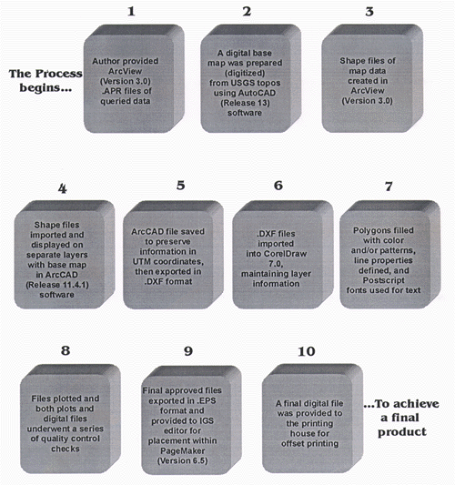
Figure 1. Summary of the process to produce maps for offset printing from GIS coverages. |
It should be noted that other software combinations were tried; the best quality for the final product was achieved using the described method. ArcView has an export function to various vector formats, but the resulting vectors imported into both CorelDraw 7.0 and Adobe Illustrator 7.0 appeared as sharp-angled lines which were unacceptable. By using ArcCAD software, the integrity of the GIS data was maintained in UTM coordinates, but was exportable in smooth, high- quality vectors. Adobe Illustrator did not easily accept the DXF files and had less functionality for our purposes than did CorelDraw. The ArcCAD export in EPS format did not seem to overcome the problems Illustrator had with the import.
The state of modern mapping will probably always be in transition, owing to the rapidly advancing technology of GIS programs, graphics software, and new digital printing processes, such as CTP. The IGS has navigated the passage to all-digital production successfully, by using this method for translating GIS data sets into accurate, high-quality, offset-printed maps.
U.S.Department of the Interior, U.S. Geological Survey
<https://pubs.usgs.gov/openfile/of98-487/sowder.html>
Maintained by Dave Soller
Last updated 10.06.98