U.S. Geological Survey
Box 25046
Denver Federal Center, MS 913
Denver, CO 80225
Telephone: (303) 236-1320
Fax: (303) 236-0214
e-mail: rwahl@usgs.gov
The National Cooperative Geologic Mapping Program (NCGMP) of the U.S. Geological Survey (USGS) is charged with the establishment of a national digital geological map database for use at a scale of 1:100,000. The NCGMP needed to test the concept of a proposed data model for a geologic map database. The Greater Yellowstone Area (GYA) is a region in which such a geologic database, when integrated with other spatial data sets, would add much to the understanding to the GYA ecosystem. The GYA is an area that is five degrees in longitude and four degrees in latitude that is centered on Yellowstone National Park. The construction of a database from 1:100,000 geologic maps requires that the geographic boundaries of each 1:100,000-scale quadrangle map be accurately known. The USGS National Mapping Division (NMD) Digital Line Graph (DLG) data at 1:100,000 scale have inaccuracies of up to 5 meters that would cause numerous problems if the data were used uncorrected for map boundaries. No one group or agency has a standard set of quadrangle map boundary files or a standard procedure to generate such files that has been proposed as a national standard. The author proposes a 1:100,000-scale map boundary standard that calls for the generation of vertices every 2 seconds of latitude and longitude. This standard results in map boundaries for 30' by 60' 1:100,000-scale maps for the conterminous United States that contain 5400 vertices and are accurate in location to less than one meter.
The Geologic Mapping Act of 1992, re-authorized in 1997, calls for the establishment of standards for digital geologic mapping both for paper plotting and for a computer-readable database. In August 1996, the Digital Geologic Mapping Committee of the Association of American State Geologists (AASG) and the U.S. Geological Survey (USGS), National Geologic Map Database Project (NGMDB) formed several working groups to devise standards and guidelines for various concepts that make up a geologic map in digital form. The NGMDB has a web site at URL:http://ncgmp.usgs.gov/ngmdbproject. One of the working groups that were established has the responsibility to develop data capture standards. The development of map boundary files might logically be a part of their charter. In addition, the working group for the distribution of digital geologic maps might wish to study this problem as well.
The problem of choosing a proper map boundary file grew in importance when I began to compile the first GYA geologic map as a pilot 1:100,000 geologic map database for the NGMDB. The pilot database will be used to supply geologic data for the GYA Science Initiative, a new part of the Integrated Natural Resources Science program (INATURES) of the USGS. The GYA encompasses an area of five degrees in longitude (108 West to 113 West) and four degrees in latitude (42 North to 46 North). Forty 30' by 60' 1:100,000-scale quadrangle maps represent the GYA.
The NGMDB has a unique opportunity to test the results of the standards efforts on a database that is needed, and that will be integrated with other geospatial data sets for ecosystem management. There is an announced need to have databases that can be clipped along known boundaries (including quadrangle boundaries) for use with other data sets clipped out with the same map boundary. Geologic data in the database will need to be updated by removing out-of-date information and adding back new information.
According to Jack Dangermond (1997) of ESRI (the producers of Arc/Info), accurate federal map digital files for map boundaries and other uses do not exist for the United States. A number of USGS geologic map compilers were asked by the author what files they used for map boundaries. The result of this informal survey indicated that each person has his or her own way of generating a map boundary. However, some state geological surveys within the USGS Central Region have had map boundary files generated by techniques established by other agencies of the state. Other problems have arisen in generating digital boundaries for 1:100,000-scale geologic maps. On one particular 1:100,000-scale published geologic map, one edge of the map is the boundary between two states rather than a line of constant longitude or latitude. Published geologic maps also come with some important geologic information outside the latitude and longitude boundaries of the map. For an example, see Figure 1.
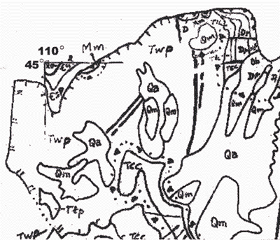
Figure 1. Northwestern corner of geologic map, enlarged from Pierce (1997). |
The Cody, WY 1:100,000-scale geologic map data exists as a film positive that was compiled by W.G. Pierce (1997) for the geologic map of the Cody 1-degree by 2-degree quadrangle. Time constraints preclude the use of larger scale maps as a source for the 1:100,000-scale map. A map boundary file was needed for this map because the data on the film positive included only the corner latitude and longitude tics (Figure 1.)
The most obvious set of digital files for use as boundary file data are the vector data contained in the Digital Line Graph (DLG) data produced by the USGS NMD. GIS specialists in the National Cooperative Geologic Mapping Program (NCGMP) of the Central Region have advised using map boundaries from the DLG files available from the Eros Data Center (EDC) of the NMD, in Sioux Falls, South Dakota. These digital map files are organized into an east and a west half for each 1:100,000 map. So to retrieve all of the DLG data for one layer for the Cody, Wyoming map, one must go to two directories for the data. I chose to get the DLG data called "boundaries," as these files contain, as a general rule a small number of vectors that need to be removed to obtain the boundary of the 1:100,000 map (Figure 2).
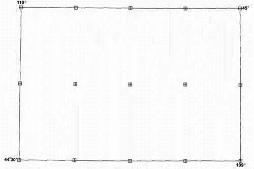
Figure 2. USGS DLG boundary file for Cody, WY. |
When this was done for the Cody, WY sheet and the lines defining the map boundary were assembled, the map corner coordinates were found to be in error from theoretical values by as much as three meters. I have learned that NMD digitizes all maps to an accuracy of 0.001 inch. At a scale of 1:100,000, positions in the digital files are accurate to 2.54 meters. While these values are well within specifications, the values nevertheless meant that geologic data retrieved using these boundary data as a clip polygon can either be in more than one map, or in no map.
Depending upon the tolerances set for building map polygons at this scale, the boundary file may not close to a polygon and discrepancies in node coordinates could require the user to manually close the map boundary polygon. Using a boundary file of this quality along with those from adjoining maps would in all probability generate "sliver polygons" that would complicate building of a map database especially when contributions to the database come from different sources.
If a need might arise to use the 15-minute map unit data as it comes from the 1:100,000-scale DLG files, similar problems could arise. For the Cody DLG data, the corner coordinates of the 15' maps, where all four maps of a 30-minute cell meet, were found to disagree among themselves by as much as 3 meters (Figure 3). Without close checking, it is not possible to tell whether the map corners overlap or whether a sliver polygon belongs to no map.
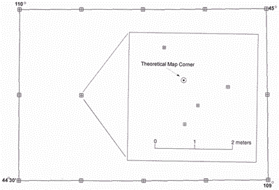
Figure 3. Four interior 15' corners in Cody, WY, DLG data. |
The first step in comparing the DLG 1:100,000-map boundary file for Cody, WY to the theoretical values for coordinates along the boundary was to compute the projection coordinates of the corners of the map. For this purpose, a text file in Arc/Info GENERATE format was created with the closed polygon coordinates in decimal degrees. The data were built into an Arc/Info coverage as a polygon. The coverage was then projected to UTM, Zone 12 coordinates using the PROJECT command in Arc. The coordinates for the four map corners were extracted from the coverage and compared to those from the DLG-derived boundary. When the computed corner coordinates displayed on a CRT screen were compared to the coordinates from the DLG boundary with the Arc DISTANCE command, the difference between the theoretical values and the DLG coordinates was as large as three meters.
A text file was made in Arc/Info GENERATE format that contained vertices every 1 minute, 15 seconds in both latitude and longitude, which gives vertices that coincide with 1:24,000-scale quadrangle corner and tic locations. The generated coverage after projection to UTM Zone 12 was compared graphically to the DLG-derived boundary. Differences as great as 2 meters separated the two boundaries (Figure 4). This particular segment of the DLG boundary file showed a break that was not closed by a CLEAN command with default tolerances set in Arc/Info. Upon further examination, the discrepancy between the two boundaries extended for about 13' of longitude. This means that if data from two Cody sources or data from Carter Mountain, WY, the 1:100,000-scale map immediately south of Cody were to be combined using different boundary files, very long but very thin sliver polygons could be created along the map boundary.
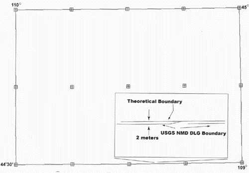
Figure 4. Difference between DLG and theoretical map boundary, Cody, WY. |
The USGS NMD uses computer-generated boundaries for its new automated mapping process. NMD uses a vertex along a map boundary every 1 minute, 30 seconds regardless of the scale of the map. Other Arc/Info users have a technique that uses the values of the map corners in degrees of latitude and longitude to generate a closed polygon. Then in ARCEDIT the command DENSIFY, with the default grain size, adds vertices along the map boundary every 0.001 degrees, which are about 80 meters apart at 44 degrees north latitude on a line of constant latitude.
The author proposes that map boundary files for 1:100,000-scale geologic maps be generated by inserting vertices every 2 seconds in both latitude and longitude. This would generate 5400 vertices in the boundary file that are about 22 meters apart at 44 degrees north latitude and would be, using single precision, accurate to less than one meter. In addition, this would allow new data from 1:24,000-scale maps to be added in with the map corners and interior tic marks at vertices on the 1:100,000-scale boundary. This proposal is a starting point from which a standard can be developed. The question now is what is the next step to arrive at standard 1:100,000-scale boundary files?
The author believes that to properly generate a geologic map database at a scale of 1:100,000, a standard set of boundary files needs to be developed. The proposed standard is a strawman meant to provoke discussion.
While this subject might seem trivial in the face of other standards problems, it is representative of the nuts-and-bolts problems that must be addressed by the adoption of reasonable standards that will allow the construction of a national geologic database. These issues need to be resolved quickly to allow use of accurate map boundaries so that work in progress in the geosciences will not have to be revised when standards are adopted. Adoption of reasonable standards for such items as map boundary files will allow the building of geoscience databases from multiple data sets covering the same area and the subsequent extraction of this data from a combined database.
Dangermond, Jack, 1997, Presidential address: ESRI User Conference, San Diego, CA.
Pierce, W.G., 1997, Geologic map of the Cody 1-degree by 2-degree quadrangle, northwestern Wyoming, U.S. Geological Survey Miscellaneous Investigations Map I-2500.
U.S.Department of the Interior, U.S. Geological Survey
<https://pubs.usgs.gov/openfile/of98-487/wahl.html>
Maintained by Dave Soller
Last updated 10.06.98