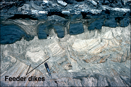
20. Site where liquefaction has been severe enough to intrude and partly destroy a basal, very soft and friable basal silty stratum; initial bedding in sand along the base of the fine-grained cap has been largely destroyed. Scale is indicated by the pocketknife in the foreground, which is about 10 cm long. Liquefaction along the base of the cap has eroded and intruded into the silty stratum (the blue stratum, about 15 to 20 cm thick) at many places. (About 20 cm from the left side of the silty stratum, the sand filling (light colored) down through the stratum is from above and was probably caused by erosion and deposition during flooding.) Note the numerous relatively large, steeply dipping (feeder) dikes extending far down into the source sand; such well-developed feeder dikes are often found at sites of severe liquefaction, but feeder dikes in source beds at sites of minor liquefaction effects are much less conspicuous and are often difficult to locate. Where liquefaction has been severe, the feeder dikes going up into a fine-grained cap are typically more or less planar, as the photograph shows (but the feeder dikes can also be tubular, depending on the properties of the cap, as will be seen later). Tubular feeder dikes that feed into small- to moderate-sized planar dikes (less than about 15 cm wide at the base of the dike) in a fine-grained cap are only occasionally (rarely) encountered.
For more information, contact Stephen F. Obermeier