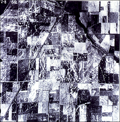
29. Distance across this aerial photograph
is about 3 miles (5 km). The photograph shows where sand was vented
through linear dikes in an area where no significant topographic
depressions were within a few kilometers of many of the dikes;
therefore, lateral spreading is unlikely as the origin of the
linear dikes. These dikes, mainly parallel to one another, were
probably formed by surface oscillations. Ground breakage from
surface oscillations often develops far (kilometers) from any
slopes, and dikes often form independent of geologic details of
the cap or the local field setting.
What we saw on the slides 27, 28, and 29 is important for eliminating a nonseismic origin of
the dikes in the region. Two nonseismic mechanisms must be considered
as possibly causing dikes in any study area: nonseismic landsliding
and artesian springs.
Nonseismic landslides can be eliminated in the two aerial photographs (slides 27 and 29) because the dikes have formed so far away from any significant slopes. Artesian conditions often can be eliminated for a similar reason, because artesian conditions typically require a special field setting such as that shown in the next slide.
For more information, contact Stephen F. Obermeier