Survey Number 7--SIDESCAN SONAR IMAGE, SURFICIAL GEOLOGIC INTERPRETATION, AND BATHYMETRY OFF ROANOKE POINT, NEW YORK
Lawrence J. Poppe 1, Ralph S. Lewis2, Richard P.
Signell1, Harley J. Knebel1,
Mohabir Persaud3, Jane F. Denny,1, Kenneth F. Parolski,1,
and Mary L. DiGiacomo-Cohen, 2
1 U.S. Geological Survey, Woods Hole, MA 02543
2Long Island Sound Resource Center, Connecticut Geological and Natural History
Survey,
Department of Environmental Protection, 1084 Shennecossett Road, Avery Point, Groton, CT
06340
3 Division of Coastal Resources, New York State Department, 162 Washington
Ave., Albany, NY 12231
The U.S. Geological Survey has produced detailed geologic maps of the sea floor in Long Island Sound, a major U.S. east-coast estuary surrounded by the most densely populated region of the United States. These studies build upon cooperative research with the State of Connecticut that was initiated in 1982. During the initial phase of this cooperative program, geologic framework studies in Long Island Sound were completed (Lewis and Needell, 1987; Needell and others, 1987; Lewis and Stone, 1991). The second and current phase of the program emphasizes studies of sea floor sediment distributions, processes that control these distributions, nearshore environmental concerns, and the relationship of benthic community structures to the sea floor geology.
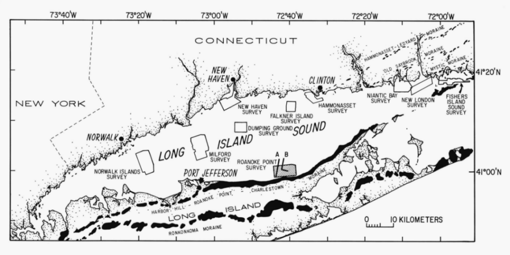
Anthropogenic wastes, toxic chemicals, and changes in land use patterns from residential, commercial, and recreational development have stressed the environment of the Sound causing degradation and potential loss of benthic habitats (Long Island Sound Study, 1994). Detailed maps of the sea floor are needed to help evaluate the extent of adverse impacts and manage resources in the future. Therefore, in a continuing effort to better understand Long Island Sound, we have constructed sidescan sonar mosaics (complete-coverage acoustic images) within specific areas of special interest (fig. 1). The mosaic presented here covers approximately 34 km2 of the sea floor off Roanoke Point, New York, in southeastern Long Island Sound (figs. 1 and 2). This site was selected because it contains one of the largest cape-associated shoal complexes along the north shore of Long Island, a feature that is clearly important to an understanding of the sediment transport regime in this part of the Sound. Interpretations of the mosaic also: (1) define the geological variability of the sea floor, one of the primary controls of benthic habitat diversity; (2) provide a detailed framework for future research, monitoring, and management activities; and (3) improve our understanding of the processes that control the distribution and transport of bottom sediments, benthic habitats, and associated infaunal community structures. The sidescan mosaics also serve as base maps for the subsequent selection of sampling sites and to the accurate interpretation of point measurements.
Long Island Sound is about 182 km long by a maximum of 32 km wide. It is bordered on the north by the rocky shoreline of Connecticut, on the west by the East River and the urbanized New York metropolitan area, on the east by Block Island Sound, and on the south by the sandy bluffs of Long Island, New York.
The bedrock beneath Long Island Sound dips southward and is composed of gneissic and schistose metamorphic rocks of pre-Silurian age similar to the bedrock exposed in southern Connecticut and on western Long Island (Grim, 1970, Rodgers, 1985). Coastal-plain sediments of Cretaceous age overlie the bedrock across most of the southern portion of the Sound and form a southward and eastward thickening wedge beneath Long Island (Fuller, 1914). Wells drilled on Long Island have encountered a coastal-plain section composed the white micaceous sands and blue, white and red clays of the Raritan Formation and the coarser, yellow and darker gravels, sands, and clays of the overlying Magothy Formation (Fuller, 1914).
At least two tills, one of early Wisconsinan-Illinoian age and one of late Wisconsinan age, overlie pre-Pleistocene strata on Long Island and beneath the Sound (Lewis and Needell, 1987; Needell and others, 1987; Stone and others, 1992). The older till is patchy, compact, eroded, and oxidized to a yellowish brown, and includes the Manhasset Formation, Jameco Gravel and Mannetto Gravel of Long Island (Schafer and Hartshorn, 1965) and the till exposed on Falkner Island (Gordon, 1980).
The late-Wisconsinan Laurentide Ice Sheet reached southern Long Island where its terminal position is marked by the Ronkonkoma Moraine (Fuller, 1914). The northward retreat of this ice sheet about 19.5 ka produced the Harbor Hill-Roanoke Point Moraine across northern Long Island (Sirkin, 1967; Schafer and Hartshorn, 1965) and a succession of minor recessional moraines in Connecticut including the the Hammonasset-Ledyard, Old Saybrook, and Mystic Moraines (Flint and Gebert, 1976; Goldsmith, 1982; Poppe and others, 1997a).
The deltaic and varved deposits of glacial Lake Connecticut variously overlie the glacial drift in the Long Island Sound basin (Lewis and Stone, 1991; Stone and others, 1992). This lake, which occupied most of the basin, was formed when the last ice front began to recede from the Harbor Hill-Roanoke Point Moraine position and meltwater was impounded in the expanding, long, narrow basin between the moraine and the retreating ice to the north (Stone and Borns, 1986).
The coastal plain, glacial drift, and glaciolacustrine deposits are truncated by an unconformity. This unconformity is a composite product of the subaerial exposure, which occurred after glacial Lake Connecticut drained, and of the marine transgression that occurred after 15 ka (Lewis and Stone, 1991). A marine mud facies, which occurs in quiet-water areas throughout the western and central parts of the Long Island Sound basin, records deposition during the postglacial eustatic rise of sea level.
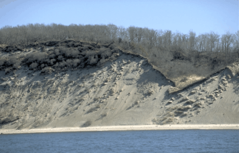
The northern shoreline of Long Island east of Port Jefferson is classified as a Glacial Deposition Coast (Shepard, 1963) because it coincides with the eroded and partially submerged portions of the Harbor Hill-Roanoke Point Moraine. This section of the shoreline is characterized by gently curved beaches separated by headlands that project slightly into the Sound. The headlands, such as Herod and Roanoke Points, have higher bluffs (up to 40 m) and more layers of erosion-resistant clay and boulders than the sand and gravel of the bluffs situated between the headlands (U.S. Army Corps Engineers, 1969; Koppleman and others, 1976).
The high bluffs on Long Island's north shore are steep, only partly covered by vegetation, and fronted by narrow beaches. The beaches near Roanoke Point average about 12 m wide (Davies and others, 1973). Both the beaches and bluffs are eroding rapidly (Bokuniewicz and Tanski, 1983); in the vicinity of Roanoke Point the average annual shoreline retreat is about 0.8 m/year (Davies and others, 1973).
DATA COLLECTION AND PROCESSING METHODS
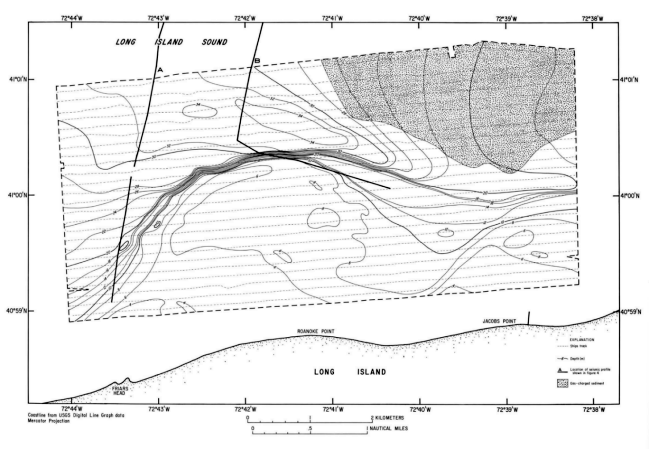
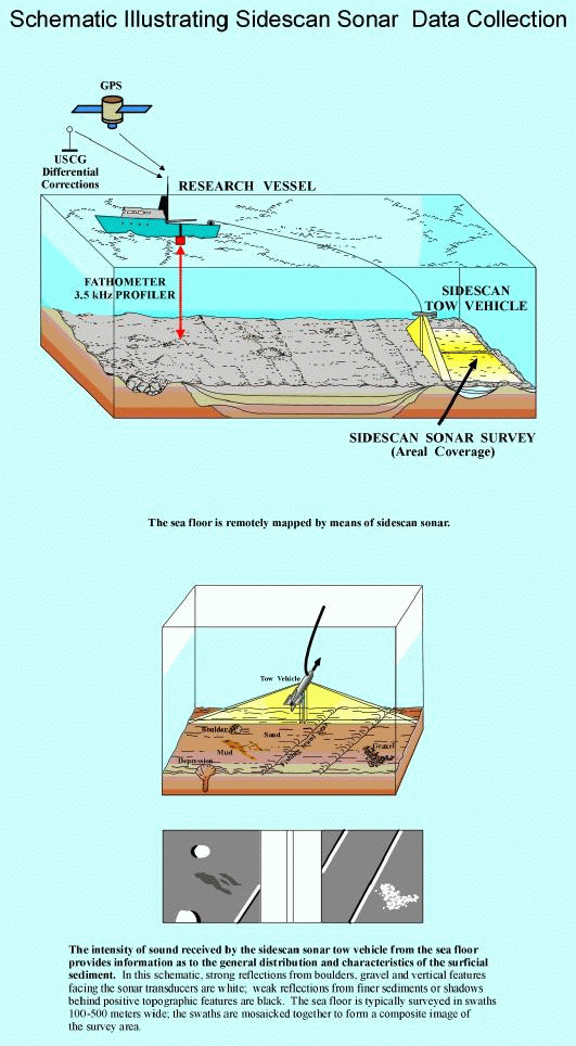
Sidescan sonar imagery, bathymetry, high-resolution seismic-reflection subbottom profiles and navigational data were collected along tracks spaced 150 m apart aboard the RV Asterias during June 1996 (fig. 2). The bathymetric data were collected using a 200-kHz echo sounder, logged digitally to a computer, and corrected for the approximately 1.89-m tidal range in the study area by adjusting the measured depth values to the predicted mean sea-level for New London, Connecticut, using commercially available software. Regional bathymetric perspectives were created using digital National Ocean Service data (fig. 3). The sidescan sonar data were collected using a SIS-1000 Datasonics sidescan sonar system set to sweep 100-m to either side of the shiptrack and logged digitally to 8-mm tape on an ISIS data acquisition system. Subbottom data were collected in digital form using 2 to 7-kHz swept frequency CHIRP and 3.5 kHz systems and, in conjunction with pre-existent Uniboom data (Needell and others, 1987), were used to interpret the stratigraphy (figs. 4A, 4B). Ship position was determined with a differential Global Positioning System (GPS); navigational data were logged on a computer at 10-second intervals.
The sidescan sonar data were processed according to procedures summarized by Danforth and others (1991) and Paskevich (1992a; 1992b). The sonar data were demultiplexed to convert the data into a processing format and to remove speckle noise, and then corrected for slant-range distortions, signal attenuation, and dropped lines that are inherent in the sonar data. A contrast enhancement based on the dynamic range of the data was applied, ship navigation was merged with the sonar data, and the data were geographically oriented and displayed on a Mercator grid.
These processed data were used to make the composite digital mosaic. Strips of sonar data were placed in their proper geographic location at the appropriate scale and projection (Paskevich (1992c). The adjacent sonar images were matched for tone, unwanted data (where two images overlapped) were digitally eliminated, and images were progressively combined into a composite digital image. Registration of features on adjacent strips of sonar data were generally good throughout the study area. The final digital mosaic, which has a 1-m pixel size, was output to film, photographically enlarged to a scale of 1:10,000, and interpreted (figs. 5, 6, and 7).
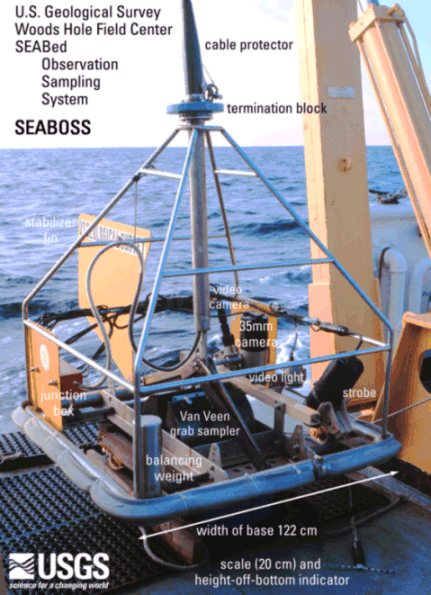
Surficial sediments (0-2 cm below the sediment-water interface) were sampled in conjunction with bottom photography at 50 locations during March 1997 aboard the RV John Dempsey using a Van Veen grab sampler equipped with a video camera system. The photographic system was used to appraise intra-station bottom variability, faunal communities, and sedimentary structures (indicative of biological and geological processes) and to observe boulder fields where samples could not be collected.
In the laboratory, the sediment samples were disaggregated and wet sieved to separate the coarse and fine fractions. The fine fraction (less than 62 microns) was analyzed by Coulter Counter (Shideler, 1976); the coarse fraction was analyzed by sieving (gravel) and by rapid sediment analyzer (sand; Schlee, 1966). The data were salt corrected.
Because biogenic carbonates commonly form in situ, they usually are not considered to be sedimentologically representative of the depositional environment. Therefore, bivalve shells and other biogenic carbonate debris were manually removed from the gravel fraction. Size classifications are based on the method proposed by Wentworth (1929). The verbal equivalents were calculated using the inclusive graphics statistical method (Folk, 1974) based on the nomenclature proposed by Shepard (1954). A detailed discussion of the laboratory methods employed are given in Poppe and others (1985). The field methods, station navigation, raw grain-size data, associated statistics, and detailed descriptions of the bottom photography are reported in Poppe and others (1997d).
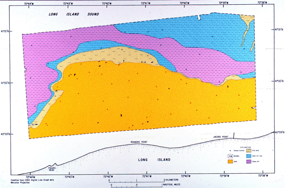
The map of surficial sediment distribution shown in figure 8 is based on data from the sediment sampling and bottom photography stations, on tonal changes in backscatter on the sidescan sonar image, and on the bathymetry.
The tide-corrected bathymetry was contoured at 2-m intervals to facilitate an understanding of the geomorphology of the Roanoke Point Shoal (fig. 2). This perspective is important because the bathymetry is related to the evolution and stability of the shoal and to the physical and biological systems along the north shore of Long Island.
The Roanoke Point Shoal, which extends perpendicular to the shoreline, is asymmetrical about its axis. Minimum water depths are less than 4 m along the shoreward edge of the study area just west of both Roanoke and Jacobs Points (fig. 2). A ridge less than 6-m deep forms a Ahook@ that extends from the bathymetric high along the westward side of the Roanoke Point Shoal in a seaward convex arc that continues eastwards around the tip of the shoal. The ridge accentuates the asymmetry and causes the topography to be steeper on the western and northern flanks and gentler and open on the eastern flank (figs. 2 ,3). The gradient across the flank exceeds 9o off the northern tip of the shoal.
Maximum water depths in the study area exceed 34 m and occur in isolated bathymetric lows within a curved depression off the tip of the shoal. Away from the shoal, water depths increase toward the northwest and connect with an elongate axial depression that extends the length of the Sound, whereas they shallow to the northeast and in the areas between the adjacent shoals (fig. 3). This figure also suggests that similar bathymetric features characterize the other shoals along the north shore of Long Island.
Near-surface Seismic Character
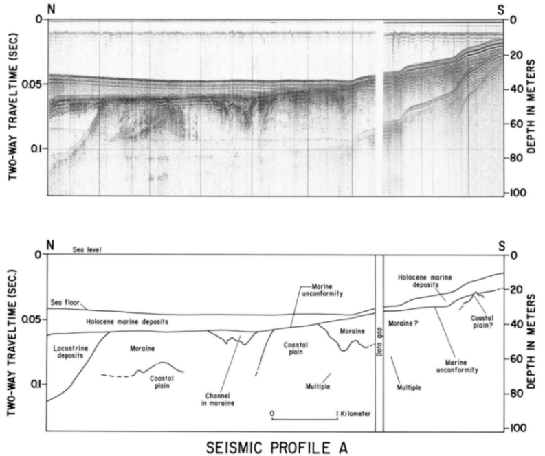
Seismic-reflection profiles provide information on the subsurface geology and its relationship to surficial processes and sediment distributions (fig. 4). Coastal-plain strata of Cretaceous age comprise the oldest unit that can be recognized on the profiles. This unit is characterized by a strong reflection from its upper surface and the local presence of nearly-continuous, subhorizontal internal reflectors.
Glacial drift, composed primarily of till, unconformably overlies the coastal-plain strata. The till, which is characterized by a well-defined upper reflector and highly irregular and discontinuous internal reflectors (Needell and others, 1987), rises shoreward toward Long Island and toward an elongate subsurface high that apparently continues rising landward beneath the shoal. This high may represent an erosional remnant tracing the retreat of the headland and may be evidence for some structural control during the formation of the shoal. Channels and basins in the drift surface are filled with younger sediments (fig. 4A).
Glaciolacustrine strata composed of fan, varved lake muds, and deltaic sediments deposited in glacial Lake Connecticut (Lewis and Stone, 1991) overlie the glacial drift. These lake deposits are absent beneath the shoal, occurring only in the offshore part of the study area (figs. 4A and 4B).
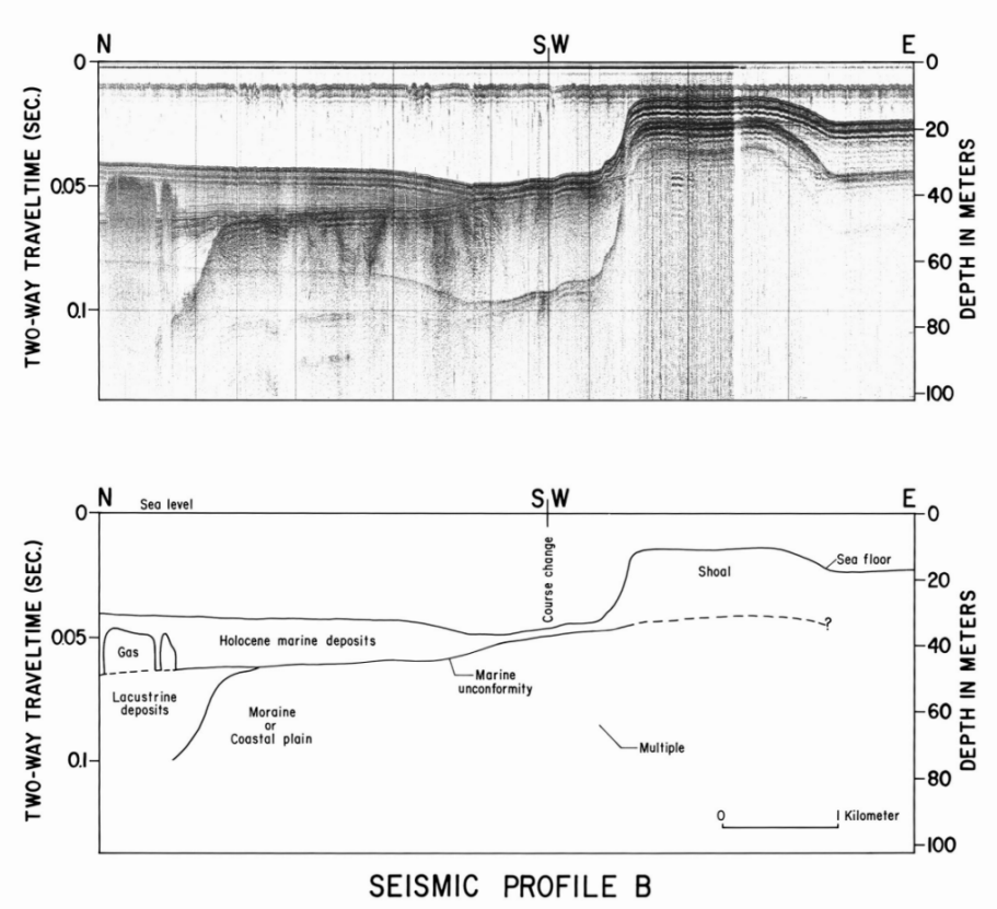
Holocene marine sediments, which exhibit persistent, subhorizontal internal reflectors, overlie the marine unconformity. The thickness of the Holocene unit thins to less than 1 m in a band around the base of the shoal and over a seaward-dipping subsurface high composed of glacial drift that extends north-northwest from the shoal. Gas-charged sediments, the result of biogenic methane from decaying organic matter, occur in the thicker Holocene strata northeast of Roanoke Point and obscure the underlying units (figs. 2 and 4B).
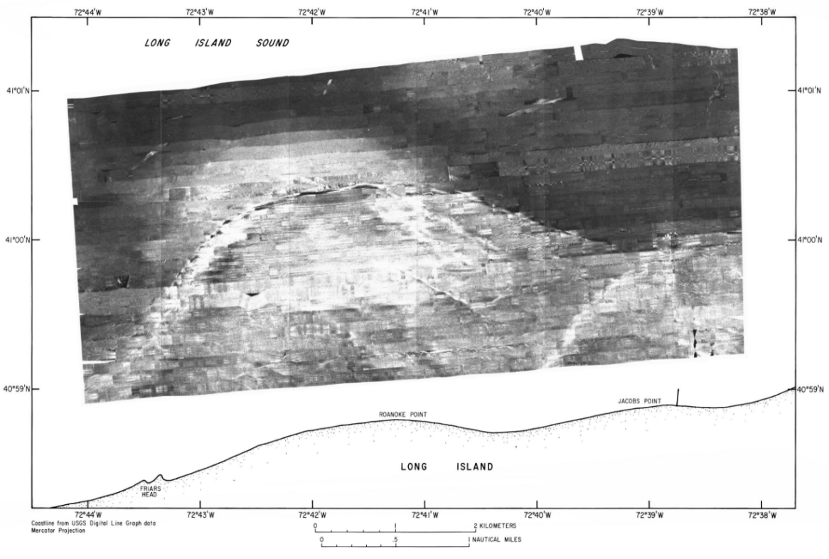
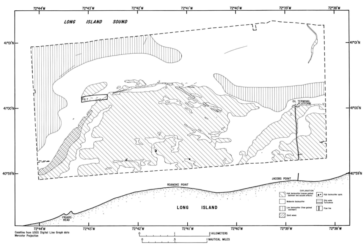
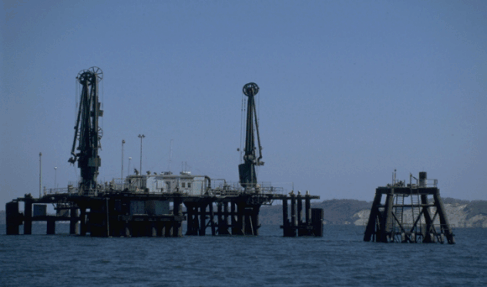
The sidescan sonar mosaic reveals an acoustic image of the sea floor that, when combined with the subbottom and bathymetric data, can be used to interpret the surficial geology of the Roanoke Point Shoal (fig. 5, 6, and 7). Distinctive acoustic patterns present on this mosaic include: higher backscatter (light tones), moderate backscatter, lower backscatter (dark tones), and elongate patches of alternating high and low backscatter (sand waves). Boundaries between areas characterized by these patterns are commonly gradational and backscatter is not uniform throughout these areas. Water column phenomena, such as ship wakes and turbulence around obstructions, can be observed on the image as well as anthropogenically produced structures, such as an oil platform and associated pipeline.
Areas characterized by high backscatter, which primarily coincide with deposits of coarser-grained sediments (fig. 8), occur on the Roanoke and Jacobs Point Shoals. For example, the sediments within the high backscatter areas on the shoal are slightly coarser grained than those sediments within the areas on the shoal characterized by moderate backscatter; means average 1.26 f and 1.67 f, respectively. Arcs of high backscatter are present along the western edges of the shoals and occur as somewhat straighter features on the eastern part of the Roanoke Point Shoal. Although the sediments in the arcs are coarser than in the areas of moderate backscatter and the arcs correspond with bathymetric highs, much of the backscatter from these features is related to topographic change and the angle of incidence of the sonar.
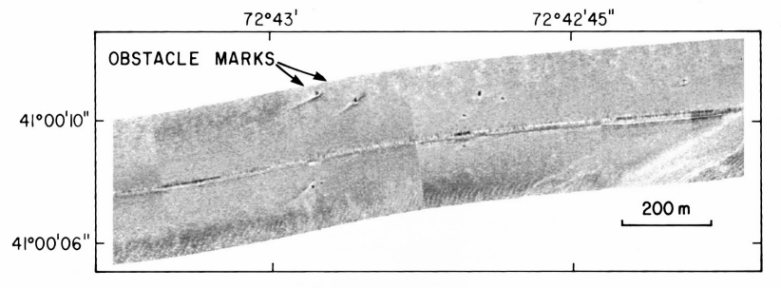
High-backscatter is also associated with isolated "spots" and small lobes that extend seaward from the northern base of the Roanoke Point Shoal. The isolated "spots" are primarily scattered in two bands, one along the shoreward edge of the study area and another around the northern base of Roanoke Point Shoal. The "spots" of high backscatter originate from large individual boulders, probably glacial erratics, that rest on the surface of the Pleistocene drift, but, as in the case of those around the northern base of the shoal, protrude up through the thin Holocene marine section. Linear accumulations of sediment, which appear as streaks of high backscatter, extend from some of the boulders (fig. 7). The lobes of high backscatter result from slope failure and mass-wasting events that cause coarser sediments from the shoal to extend onto the basin floor.
The areas characterized by relatively low backscatter include most of the basin floor surrounding the shoals, except for the area just north-northwest of the Roanoke Point Shoal. These parts of the study area coincide with deposits of finer-grained, Holocene, marine sediments. The average mean grain size of the sediments in the areas of low backscatter is 6.81 f.
Elongate patches of alternating high and low backscatter an acoustic pattern produced by sand waves, occur in a narrow bands along the western and northeastern upper flanks of the Roanoke Point Shoal (figs. 5, 6). The alternation in backscatter that creates this pattern is due to a combination of topographic changes (because the angle of incidence of the sonar changes) and the differences in sediment texture between crests and troughs. The sand waves are typically less than 1 m high with average wavelengths of less than 20 m. The asymmetry of the sand waves on the CHIRP subbottom records suggests that the net transport direction in both sand-wave fields is toward the tip of the shoal. Although portions of the image on top of the shoal exhibit a pattern similar to that of sand waves, the direction alternates from line to line creating a herringbone effect and the pattern does not continue from line to line. In these instances the pattern is due to acoustic noise from surface-wave conditions in the shallow water. Turbulence from ship wakes and currents around obstructions also produce patches of alternating high and low backscatter on the image. The faint high-backscatter band, which trends northward from about 1.2 km off the Jacobs Point Shoal, appears to result from the reworking of sediments dredged, presumably, to lay a pipeline or cable.
Surficial Sediment Distribution
The locations of the sample and photographic stations and the surficial sediment distribution are shown in figure 8. On the basis of lithology, texture, and faunal assemblages, four major sedimentary facies were identified within the study area. Contacts between these environments are gradational and changes in lithology are seldom abrupt.
Facies 1 is located on the crests of the Roanoke Point and Jacobs Point Shoals in water depths of less than 10 m. This depositional environment is subjected to the highest energy levels relative to the other facies because of its relief above the wave base and the surrounding basin floor of the Sound. For example, numerical models (Signell and others, 1998) show that orbital wave velocities on top of the shoal (the speed necessary to cause resuspension) exceed 15 cm/sec over 30 percent of the time and that spring tidal currents exceed 30 cm/sec. Facies 1 is characterized by clean, medium-grained, moderately-to-moderately well sorted, siliciclastic sand. The sand, which has means between 1 and 2f and unimodal distributions, is typically finely skewed to nearly symmetrical, generally contains little or no gravel, and less than 1 percent fines (silt plus clay). A few, small bouldery patches are scattered over the central, nearshore part of the Roanoke Point Shoal. Current ripples are ubiquitous. Shells and shell debris and, occasionally, fine-grained organics are concentrated in the ripple troughs. Scattered worm tubes and clam burrows were observed in the bottom video.
Facies 2, which is present in water depths of between 10 and 22 m, occurs on the flanks of the shoal and represents the rapid transition from shallow to deeper water depositional conditions. Sediments in this facies are typically composed of medium-to-fine grained, poorly-to-very poorly sorted sand. Sediments become coarser westward and more finely skewed and platykurtic eastward. Worm tubes and hermit crabs are more common in this environment than in the shoal-crest facies. Shells and shell debris, which commonly fill the troughs of current ripples and armor the bottom, were observed in the bottom video cascading downslope.
Facies 3 forms a basal apron around the shoal front and floors the isolated depressions north of the Roanoke Point Shoal. Inorganic sediments in this environment form a seaward progression of poorly sorted, finely skewed, platykurtic, very fine grained sand, silty sand, and sand-silt-clay. Biogenic debris, including clam (quahog and razor), welk, and snail shells and shell hash, comprise most of the bulk sediment in a narrow band at the base of the shoal edge, producing a clast-supported fabric. Current ripples are more conspicuous here than in areas dominated by facies 4; rock crabs are common.
Facies 4, which represents the basin floor environment in this portion of Long Island Sound, occurs northwest of the Roanoke Point Shoal and along the edges of the eastward-trending trough north of the shoals. The sediments in facies 4 are generally very poorly sorted, bi-modal, nearly symmetrical to coarsely skewed, and mesokurtic to very platykurtic clayey silt and sand-silt-clay. Evidence for transport is limited to faint current ripples, shallow scour features around shells, and a variegated appearance due to current-swept organics. Worm and amphipod tubes as well as shrimp and clam burrows are abundant in the heavily bioturbated bottom; spider crabs and anemones are common component of the faunal assemblage.
The main current regimes controlling sedimentary processes around the Roanoke Point Shoal include: a wind- and wave-driven regime, which predominates nearshore, and a tidal regime that predominates offshore around the edges of the shoal. Precipitation, ground-water discharge, freeze and thaw cycles, mass wasting (slumping and gravitational sliding), wind-driven waves associated with storms, and sea-level rise all play important roles in bluff erosion and the evolution of the northeastern coast of Long Island (Davies and others, 1973; U.S. Army Corps Engineers, 1975). As the bluffs recede, the eroded sediments accumulate as talus on the narrow beaches. Wave attack during storms removes the talus and can erode the bluffs. Boulders and coarse gravel remain on the beach as lag deposits; the finer-grained sediments are winnowed away. The mean high water line migrates landward as the beach deposits are removed and the cycle of bluff and beach erosion continues. Normal circulation in the Sound and prevailing westerly winds combine to set up an eastward longshore littoral drift as indicated by beach accretion on the west or upstream side of jetties, groins, and other obstructions and by erosion on the sediment-starved east or downstream side, such as occurs near Friars Head (Omholt, 1974; Schmalz, 1993; fig. 2).
The sediments are transported easterly along the coast to headlands where they are deflected offshore. The sands accumulate in a series of shore-connected, cape-associated arcuate shoals, such as the shoals present off Roanoke and Jacobs Points; the silts and clays are moved further offshore to lower-energy environments. This mechanism continuously supplies sand to sustain the shoal and finer grained sediment to the basin floor and to the protected areas between adjacent shoals (fig. 3). In addition to acting as sediment sinks in the longshore regime, the shoals also serve to shield the headlands from wave action (Swift and others, 1972). Because the onshore transport of offshore sediments from the deeper, lower energy benthic environments of the Sound is minimal (U.S. Army Corps Engineers, 1969), bluff erosion and the longshore transport are the major processes affecting the delivery of sediments to these shoals.
The topographic character of the Roanoke Point Shoal differs from earlier work on cape-associated shoals (Swift and others, 1972; Duane and others, 1972) and shoreface-attached sand ridges (Swift and others, 1984; McBride and Moslow, 1991) which shows that most shoreface-attached shoals are open to and have gentler slopes on their up-drift sides. We attribute the differences in topography to a greater sediment supply and to the narrower foreshore along the north shore of Long Island. Near Truro, Massachusetts, for example, a repetitive series of hooked bars beneath the offshore-facing sea cliffs near Truro, Massachusetts have morphologies similar to the Roanoke Point Shoal (Uchupi and others, 1996). Their association with rapidly-eroding sea cliffs suggests that an ample sediment supply is important to the development of this topographic character.
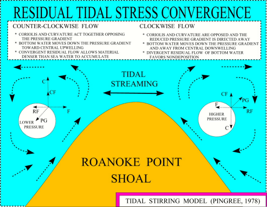
Construction of the gross tidal flow around cape-associated shoals leads to increased tidal speeds off the tips of the shoals and weaker tidal velocities in adjacent bays or indentations between the shoals (Pingree, 1978). Tidal currents, through their strength and oscillatory nature, help to control the overall shape and extent of the Roanoke Point Shoal and are responsible for the steep gradients on the flanks, the cuspate shape of the slump deposits at the base of the northern flank, the accumulations of sediment in the current shadows of boulders, and the ubiquitous presence of current ripples on the shoal. The strong tidal currents deflected around the shoal, through sediment bypassing or decreased deposition, are also responsible for the thinness of the Holocene section and the curved depression in the Long Island Sound basin floor north of the shoal (figs. 2 and 4).
Although relatively equal volumes of water move during ebb and flood tides, residual tidal stress convergence occurs when one tide is stronger, causing net circulation and bedload transport. A stronger flood tide off Roanoke Point (Eldridge Tide and Pilot Book, 1996) results in a residual westward transport, as evidenced by the asymmetrical accumulations of sediment in the current shadows around boulders (Stride, 1982; fig. 7). This residual flow is also apparently strong enough to sweep fine sands off the northern flank of the shoal, which are subsequently deposited on the basin floor northwest of the shoal (fig. 5), and to possibly permit transport by eddy patterns characteristically associated with headlands (Pingree, 1978). In Pingree's mechanism a counter-clockwise flood-tide eddy west of Roanoke Point Shoal: Coriolis and centrifugal force act together opposing the pressure gradient, bottom water moves down the pressure gradient toward central upwelling, and the convergent residual flow allows sandier material to accumulate. Conversely in the clockwise ebb-tide eddy east of the shoal: Coriolis and centrifugal force are opposed, bottom water moves away from central downwelling, and divergent residual flow of bottom water favors nondeposition. These processes are consistent with the occurrence of coarser sediments and a high-backscatter area west of the shoal and by the finer grained sediments and low backscatter east of the shoal.
Wind-generated waves and strong tidal currents continue to extensively erode and rework both the glacial and post-glacial deposits and to influence the sedimentary processes around the Roanoke Point Shoal. The irregular bottom topography and textural distributions reflect these processes.
This survey was conducted in cooperation with the State of Connecticut, Department of Environmental Protection, Geological and Natural History Survey. We thank Dave Olmsted who captained the Woods Hole Oceanographic Institution vessel RV Asterias and Peter Simpson and Miles Peterle of the Connecticut Department of Environmental Protection for providing shipboard support aboard the RV John Dempsey and onshore logistical support. This map has benefitted from critical reviews by Linda Lotto and Dave Twichell (both USGS). Any use of trade, product, or firm names is for descriptive purposes only and does not imply endorsement by the U.S. Government or the State of Connecticut.
Bokuniewicz, H.J., and Tanski, J.J., 1983, Sediment partitioning at an eroding coastal bluff: Northeastern Geology, v. 5, p. 73-81.
Danforth, W.W., O'Brien, T.F., and Schwab, W.C., 1991, USGS image processing system: near real-time mosaicking of high resolution side scan SONAR data: Sea Technology, v. 32, p. 54-60.
Davies, D.S., Axelrod, E.W., and O=Conner, J.S., 1973, Erosion of the north shore of Long Island: Marine Sciences Research Center, State University of New York Technical Report 18, 101 p.
Duane, D.B., Field, M.E., Meisburger, E.P., Swift, D.P., and Williams, S.J., 1972, Linear shoals on the Atlantic inner continental shelf, Florida to Long Island: In D.P. Swift, D.B. Duane, and O.H. Pilkey (Eds.), Shelf Sediment Transport - Process and Pattern, Dowden, Hutchinson, and Ross, Stroudsburg, PA, Chapter 22, p. 447-498.
Eldridge Tide and Pilot Book, 1996, Marion Jewett White, Boston, 272 p.
Flint, R.F., and Gebert, J.A., 1976, Latest Laurentide ice sheet - new evidence from southern New England: Geological Society of America Bulletin, v. 87, p. 182-188.
Folk, R.L., 1974, The petrology of sedimentary rocks: Hemphill Publishing Co., Austin, 182 p.
Fuller, M.L., 1914, The geology of Long Island, New York: U.S. Geological Survey Professional Paper 82, 231 p.
Goldsmith, Richard, 1982, Recessional moraines and ice retreat in southeastern Connecticut: In G.J. Larson and B.D. Stone (editors), Late Wisconsinan Glaciation of New England, Kendall/Hunt Publishing, Dubuque, p. 61-76.
Gordon, R.B., 1980, The sedimentary system of Long Island Sound: Advances in Geophysics, v. 22, p. 1-36.
Grim, M.S., Drake, C.L., and Heirtzler, J.R., 1970, Subbottom study of Long Island Sound: Geological Society America Bulletin, v. 81, p. 649-666.
Kopplemann, L.E., Weyl, P.K., Gross, M.G., and Davies, D.S., 1976, The Urban Sea - Long Island Sound: Praeger Publishers, New York, 223 p.
Lewis, R.S., and Stone, J.R., 1991, Late Quaternary stratigraphy and depositional history of the Long Island Sound basin: Connecticut and New York: Journal Coastal Research, Special Issue 11, p. 1-23.
Lewis, R.S., and Needell, S.W., 1987, Maps showing the stratigraphic framework and quaternary geologic history of eastern Long Island Sound: U.S. Geological Survey Miscellaneous Field Studies Map MF-1939-A, 7 p., 3 sheets.
Long Island Sound Study, 1994, The Long Island Sound Study - The Comprehensive Conservation and management Plan, 168 p.
McBride, R.A., and Moslow, T.F., 1991, Origin, evolution, and distribution of shoreface sand ridges, Atlantic inner shelf, USA: Marine Geology, v. 97, p. 57-85.
Moffett, A.M., Poppe, L.J., and Lewis, R.S., 1994, Trace metal concentrations in sediments from eastern Long Island Sound: U.S. geological Survey Open-File Report 94-620, 17 p.
Needell, S.W., Lewis, R.S., and Colman, S.M., 1987, Maps showing the Quaternary geology of east-central Long Island Sound: U.S. Geological Survey Miscellaneous Field Studies Map MF-1939-B, 3 sheets.
Omholt, Thore, 1974, Effects of small groins on shoreline changes on the north shore of Suffolk County, New York: New York Ocean Sciences Laboratory technical Report No. 0028, 44 p.
Paskevich, Valerie, 1992a, Woods Hole Image Processing System software implementation: using NetCDF as a software interface for image processing: U.S. Geological Survey Open-File Report 92-25, 66 p.
________, 1992b, Digital processing of side-scan sonar data with the Woods Hole Image Processing System software: U.S. Geological Survey Open-File Report 92-204, 9 p.
________, 1992c, Digital mapping of side-scan sonar data with the Woods Hole Image Processing System software: U.S. Geological Survey Open-File Report 92-536, 87 p.
Pingree, R.D., 1978, The formation of the Shambles and other banks by tidal stirring of the seas: Journal of the Marine Biological Association of the United Kingdom, v. 58, pp. 211-226.
Poppe, L.J., Eliason, A.H., and Fredericks, J.J., 1985, APSAS - An automated particle size analysis system: U.S. Geological Survey Circular 963, 77 p.
Poppe, L.J., Lewis, R.S., and Moffett, A.M., 1992, The texture of surficial sediments in northeastern Long Island Sound: U.S. Geological Survey Open-File Report 92-550, 13 p.
Poppe, L.J., Lewis, R.S., Quarrier, Sidney, Zajac, Roman, and Moffett, A.M., 1994, Map showing the distribution of surficial sediments in Fishers Island sound, New York, Connecticut, and Rhode Island: U.S. Geological Survey Miscellaneous Field Studies Map I-2456, 1 sheet.
Poppe, L.J., Denny, J.F., Parolski, K.F., Lewis, R.S., and DiGiacomo-Cohen, M.L., 1996, Sidescan sonar imagery of the Long Island Sound sea floor in Niantic Bay, Connecticut: EOS, v. 77, p. 146.
Poppe, L.J., Lewis, R.S., Zajac, R.N., Twichell, D.C., Schmuck, E.A., Parolski, K.F., and DiGiacomo-Cohen, M.L., 1997a, Sidescan sonar image, surficial geologic interpretation, and bathymetry of the Long Island Sound sea floor off Hammonasset Beach State Park, Connecticut: U.S. Geological Survey Miscellaneous Field Studies Map MF-2318, 2 sheets.
Poppe, L.J., Denny, J.F., Parolski, K.F., Lewis, R.S., and DiGiacomo-Cohen, M.L., 1997b, Sidescan sonar image and geologic interpretation of the sea floor in Fishers Island Sound, Connecticut, New York, and Rhode Island: Geological Society of America, v. 29, p. 75.
Poppe, L.J., Denny, J.F., Parolski, K.F., Knebel, H.J., Lewis, R.S., and DiGiacomo-Cohen, M.L., 1997c, Sidescan sonar image and geologic interpretation of the seafloor near Falkner Island, Connecticut: Geological Society of America, v. 29, p. 90.
Poppe , L.J., Taylor, B.B., Blackwood, Dann, Lewis, R.S., and DiGiacomo-Cohen, M.L., 1997d, The texture of surficial sediments in southeastern Long Island Sound off Roanoke Point, New York: U.S. Geological Survey Open-File Report 97-529, 18 p.
Rodgers, John (compiler), 1985, Bedrock Geologic Map of Connecticut: Connecticut Natural Resources Atlas Series, Connecticut Geological and Natural History Survey, Department of Environmemtal Protection, Hartford, Connecticut, scale 1:125,000, 2 sheets.
Schafer, J.P., and Hartshorn, J.H., 1965, The Quaternary of New England, In: Wright, H.E., and Frey, D.G., (eds.), The Quaternary of the United States: Princeton, N.J., Princeton University Press, p. 113-127.
Schlee, J., 1966, A modified Woods Hole rapid sediment analyzer: Journal Sedimentary Petrology, v. 30, p. 403-413.
Schmalz, R.A., 1993, Numerical decomposition of eulerian residual circulation in Long Island Sound: In: Spaulding, M.L., Bedford, Keith, Blumberg, Alan, Cheng, Ralph, and Swanson, Craig, (eds.), Estuarine and Coastal Modeling III, Proceeding of the Third International Conference, American Society of Civil Engineers, New York, p. 294-308.
Shepard, F.P., 1954, Nomenclature based on sand-silt-clay ratios: Journal Sedimentary Petrology, v. 24, p. 151-158.
Shepard, F.P., 1963, Submarine Geology: Harper and Rowe Publishers, New York, 557 p.
Shideler, G.L., 1976, A comparison of electronic particle counting and pipet techniques in routine mud analysis: Journal of Sedimentary Petrology, v. 42, p. 122-134.
Sirkin, L., 1967, Late-Pleistocene pollen stratigraphy of western Long Island and eastern Staten Island, New York: In E.J. Cushing and H.E. Wright (Eds.) Quaternary Paleoecology, Yale University Press, New Haven, 425 p.
Signell, R.P., Knebel, H.J., List, J.H., and Farris, A.S., 1998, Physical processes affecting sedimentary environments of Long Island Sound: In: M. Spaulding and A. Blumberg (eds.) Proceedings, 5th International Conference on Estuarine and Coastal Modeling, American Society of Civil Engineers, p. 400-412.
Stone, B.D., and Borns, H.W, 1986, Pleistocene glacial and interglacial stratigraphy of New England, Long Island, and adjacent Georges bank and Gulf of Maine. In: Sibrava, V., Bowen, D.Q., and Richmond, G.M. (Eds.), Quaternary Glaciations in the Northern Hemisphere, Oxford, Pergammon Press, pp. 39-52.
Stone, J.R., Schafer, J.P., London, E.H., and Thompson, W.B., 1992, Surficial materials map of Connecticut: U.S. Geological Survey Surficial Materials Map, scale 1:125,000, 2 sheets.
Stride, A.H., 1982, Offshore Tidal Sands: Chapman and Hall, New York, 222 p.
Swift, D.P., Kofoed, J.W., Saulsbury, F.P., and Sears, Phillip, 1972, Holocene evolution of the shelf surface, central and southern shelf of North America: In D.J.P. Swift, D.B. Duane, and O.H. Pilkey (Eds.), Shelf Sediment Transport - Process and Pattern, Dowden, Hutchinson, and Ross, Stroudsburg, PA, Chapter 23, p. 499-574.
Swift, D.P., McKinney, T.F., and Lloyd Stahl, 1984, Recognition of transgressive and post-transgressive sand ridges on the New Jersey continental shelf - discussion: In R.W. tillman and C.T. Seimers (Eds.) Siliciclastic Shelf Sediment, Society of Economic paleontologists and Mineralogists special Publication no. 34, p. 25-36.
Twichell, D.C., Poppe, L.J., Zajac, Roman, and Lewis, R.S., 1995, Sidescan sonar survey of the Long Island Sound seafloor off Milford, Connecticut: Geological Society America Abstracts with Programs, v.27, p. 88.
Twichell, D.C., Zajac, Roman, Poppe, L.J., Lewis, R.S., Cross, VeeAnn, and Nichols, David, 1997, Sidescan sonar image, surficial geological interpretation, and bathymetry of Long Island Sound off Norwalk, Connecticut: U.S. Geological Survey Geologic Investigations Map I-2589, 2 sheets .
Uchupi, Elazar, Giese, G.S., and Aubrey, D.G., 1996, The late Quaternary construction of Cape Cod, Massachusetts: a reconsideration of the W.M. Davis model: Geological Society of America Special Publication 309, 69 p.
U.S. Army Corps of Engineers, 1969, North shore of Long Island, Suffolk County, New York, beach erosion control and interim hurricane study: New York District, New York, 271 p.
U.S. Army Corps of Engineers, 1975, People and the Sound - erosion and sedimentation: Planning Report of the New England River Basins Commision, Long Island Sound Regional Study, 64 p.
Wentworth, C.K., 1929, Method of computing mechanical composition of sediments: Geological Society of America Bulletin, v. 40, p. 771-790.
Figure 1. Map showing location of study area off Roanoke Point, New York. Also shown are the locations of the subbottom profiles used in figure 4, the major onshore moraines (Lewis and Stone, 1991), and the locations of other sidescan sonar surveys being completed as part of this series (Norwalk: Twichell and others (1997); Milford: Twichell and others (1995); New Haven Harbor and Dumping Grounds; Falkner Island: Poppe and others (1997c); Hammonasset: Poppe and others (1997a); Niantic Bay: Poppe and others (1996); New London: Poppe and others (1992); Moffett and others (1994); Fishers Island Sound: Poppe and others (1994, 1997b).
Figure 2. Bathymetric map of the study area. Contour interval is 2 m. Depths have been corrected for tides and are adjusted to mean sea level. Fine dashed lines represent tracks along which the geophysical data were collected. The distribution of an opaque subbottom acoustic facies interpreted to be gas-charged sediment and the locations of profiles A and B shown in figure 4, are indicated.
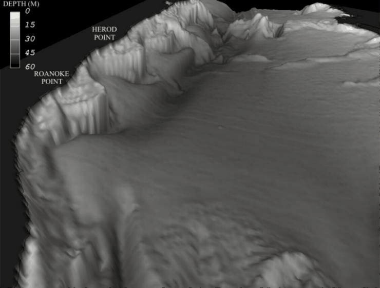
Figure 3. Regional bathymetric perspective of southeastern Long Island Sound created with digital National Ocean Service data. Figure shows the topographic character of the Roanoke Point and Herod Point Shoals, areas of erosion at the base of the shoals, sediment accumulations in the areas between the shoals, and the elongate axial depression that extends the length of the Sound.
Figure 4. Subbottom profiles (Needell and others, 1987) showing the stratigraphy and different echo-character types. (A) Uniboom profile and interpretation showing truncation of the coastal-plain (?), glacial drift, and glaciolacustrine strata by the marine unconformity. Profile also shows the thinning of the Holocene marine strata around the base of the shoal and the upper surface of the glacial drift rising shoreward. (B) Uniboom profile and interpretation showing the marine unconformity shallowing under Roanoke Point Shoal. Profile also shows gas-charged sediment, glaciolacustrine sediments, and slumping at the base of the shoal. Locations of the profiles are shown in figures 1 and 2.
Figure 5. Sidescan sonar mosaic of the sea floor off Roanoke Point, New York. Light tones on the image represent areas of high backscatter; dark tones represent areas of low backscatter.
Figure 6. Interpretation of the sidescan sonar mosaic. Different patterns are defined in the explanation and discussed in the text. Location of the section of sidescan sonar record shown in figure 7 is plotted on the interpretation.
Figure 7. Section of a sidescan sonar record from northwest of Roanoke Point Shoal. Linear high-backscatter stripes on east and west sides of boulders attest to the strong oscillatory nature of the tidal currents. Net transport direction is toward the side with the longer accumulation. Location of section is shown in figure 6.
Figure 8. Map showing the distribution of surficial sediments and the locations of the sampling and bottom photography stations (triangles). Interpretation of the sediment distribution is based on data from these stations, on tonal changes in backscatter on the sidescan sonar image (fig. 5), and on the correlation of the textural and backscatter data with the bathymetry (figs. 2, 3).
SIDESCAN-SONAR MOSAIC
The sidescan-sonar mosaic is a digital image with a 1-m pixel size ( a pixel represents one meter on the sea floor). The 52Mbyte digital image is available for viewing as a graphic in "tif" format with its associated Arcview geo-reference world file.
[an error occurred while processing this directive]